Glasgow and Milngavie Junction Railway

Last updated

Glasgow and Milngavie Junction Railway
Overview
Dates of operation1 August 186128 July 1873
Successor North British Railway
Technical
Track gauge 1,435 mm (4 ft 8+12 in)
Glasgow and
Milngavie Junction Railway
BSicon exKBSTa.svg
Ellangowan Mills
BSicon exSTR.svg
BSicon KHSTa.svg
Milngavie
BSicon exKRWl.svg
BSicon eKRWg+r.svg
BSicon exKBSTaq.svg
BSicon eABZg+r.svg
Burnbrae Dye Works
BSicon HST.svg
Hillfoot
BSicon HST.svg
Bearsden
BSicon CONTg.svg
BSicon STR.svg
Arrow Blue Up 001.svg
Glasgow, Dumbarton and
Helensburgh Railway
BSicon KRWg+l.svg
BSicon KRWr.svg
Milngavie Junction
BSicon HST.svg
Westerton
BSicon CONTf.svg
Arrow Blue Down 001.svg
Glasgow, Dumbarton and
Helensburgh Railway

The Glasgow and Milngavie Junction Railway was a short locally promoted branch line built to connect the industrial town of Milngavie with the main line railway network, near Glasgow, Scotland. It opened in 1863.

Contents

The town, and Bearsden, an intermediate location on the line, became significant residential centres, and nowadays the line is a part of the Glasgow commuter network. No freight is handled on the line.

The inventor George Bennie developed the Bennie Railplane, a system of overhead express passenger railways, and he built a demonstration section above a dormant industrial siding that branched from the line. However Bennie was unable to attract investment to implement his scheme, and the demonstration track was dismantled in 1956.

History

An independent railway

System map of the Milngavie Railway Milngavie Railway.gif
System map of the Milngavie Railway

On 28 May 1858 the Glasgow, Dumbarton and Helensburgh Railway opened its line, running from Cowlairs, where it joined the Edinburgh and Glasgow Railway a short distance north of its Queen Street terminus.

Milngavie was a rural town with considerable industry, especially in the textile printing and papermaking trades. The GD&HR was the first railway in the area north west of Glasgow, but the benefits of railway connection, in reducing the cost of commodities like coal and agricultural supplies, and in facilitating transport of manufactured goods to market, were plain to see elsewhere. Seeing that the GD&HR passed not far from their town, businesspeople in Milngavie determined to promote a branch line to make the connection. They obtained the authorising Act of Parliament for the Glasgow and Milngavie Junction Railway on 1 August 1861; the capital was £30,000. [note 1] [1] [2] [3]

Although the district was lightly populated, high class residential travel was developing in similar situations elsewhere, and was expected to be a positive factor for the Milngavie line. [4] [5]

The line was just over 3 miles (5 km) long and construction was not difficult; the line opened on 28 April 1863. [note 2] Like the GD&HR, it was worked by the Edinburgh and Glasgow Railway for 50% of gross receipts. [note 3] [6] There was one intermediate station at Bearsden. [4] [5]

South of Milngavie a short branch led to the Burnbrae Dye Works, and at Milngavie a long siding extended past the station to Ellangowan Paper Mills. There were a considerable number of goods sidings at Milngavie.

Absorbed by the NBR

On 28 July 1873 the North British Railway (General Purposes) Act was passed, authorising the takeover of the Milngavie line by the NBR. [6] The line became simply a part of the growing North Clyde network of the NBR.

The twentieth century

The line had been constructed as a single line; it was doubled on 24 April 1900. Hillfoot station was opened at the same time. [7]

The North British Railway became a constituent of the new London and North Eastern Railway in 1923, following the Railways Act 1921; in 1948 the railways were nationalised and the line was under the control of British Railways, Scottish Region.

The Bennie Railplane

The inventor George Bennie developed a system known as the Bennie Railplane; it adopted some features of the 1901 Schwebebahn in Wuppertal, Germany, the Wuppertal Suspension Railway.

It was a lightweight single vehicle suspended from an overhead track; the track was supported on gantries. The intention was that fast through passenger trains could be run above traditional railways, segregating them from slower traffic without an additional land take. The Burnbrae Dye Works branch had closed in 1926 and Bennie built a short demonstration section of his line above it. Publicity photographs taken at the time show a goods train below the Bennie vehicle, but the goods train was placed there for the photography, and was not actually in revenue service. (However the journalists and others were taken to the track's "station" by passenger train on the Dye Works branch.)

A demonstration run for the press was arranged for 4 July 1930. The vehicle was electrically powered, driving a propeller, the only electrically powered airscrew driven suspended monorail ever to be built. The vehicle made use of lightweight Duralumin in the structure and cladding of the Railplane, a material that, "to the best of [the author's] knowledge, had never previously been used structurally in railway carriage or public service vehicle design". [8] The demonstration track was 426 feet (130 m) long. Bennie attracted much attention for his scheme, and was a skilful publicist. However the system was not adopted in any practical application. Available documentation does not explain how junctions and crossovers were to be dealt with, and approaches to established railway managements in the UK and elsewhere resulted in the view that the system would abstract from, and not complement, the existing railway. Some free-standing routes were considered, particularly to airports, but were never proceeded with. Bennie was declared bankrupt in 1937. [8]

The railplane and its track were scrapped in 1956. [9] [5]

The shed where the vehicle was stored is now (2015) in use by Kelvin Timber (West) Ltd adjacent to Main Street, Milngavie; a blue plaque commemorating the trial is fixed to the wall at the point where the Burnbrae dyeworks branch, and the test track, crossed.

Electrification

The Milngavie branch (as the line had become) was electrified as part of the North Clyde modernisation scheme in 1960. There are no goods facilities on the line now. The line was partly singled under the Yoker Area Resignalling in 1990.

Current operations

Passenger services currently (2016) operate as part of the Argyle Line group of services to/from Motherwell, Cumbernauld & Larkhall, typically on a 30-minute interval, operated by ScotRail. Monday to Saturday daytimes also see a half-hourly service over the North Clyde Line to/from Edinburgh Waverley via Glasgow Queen Street Low Level and Airdrie.

Topography

Locations are:

The line from Milngavie to Hillfoot and from Bearsden to Westerton Junction is single line. [11]

Notes

  1. Awdry says (page 132) that the Act was procured by the GD&HR. It is difficult to see what he means by this, and it is not supported by contemporary sources.
  2. According to Paterson, Smith and Quick; Carter and Awdry give 21 April 1863; Ross gives 20 April 1863 (page 59).
  3. Paterson says it was worked by the NBR, but the NBR had no locus in the area until 1865.

Related Research Articles

<span class="mw-page-title-main">Bearsden</span> Town in East Dunbartonshire, Scotland

Bearsden is a town in East Dunbartonshire, Scotland, on the northwestern fringe of Greater Glasgow. Approximately 6 miles (10 km) from Glasgow City Centre, the town is effectively a suburb, and its housing development coincided with the 1863 introduction of a railway line. The town was named after Bearsden railway station, which was named after a nearby cottage.

<span class="mw-page-title-main">North Clyde Line</span> Railway line in Glasgow City, Scotland, UK

The North Clyde Line is a suburban railway in West Central Scotland. The route is operated by ScotRail Trains. As a result of the incorporation of the Airdrie–Bathgate rail link and the Edinburgh–Bathgate line, this route has become the fourth rail link between Glasgow and Edinburgh.

<span class="mw-page-title-main">Bennie Railplane</span> Electric propeller-based suspension railway

The Bennie Railplane was a form of rail transport invented by George Bennie (1891–1957), which moved along an overhead rail by way of propellers.

<span class="mw-page-title-main">Maryhill Line</span> Railway line in Glasgow, Scotland, UK

The Maryhill Line is a suburban railway line linking central Glasgow and Anniesland via Maryhill in Scotland. It is part of the Strathclyde Partnership for Transport network. The line between Glasgow and Maryhill forms a part of the West Highland Line and was reopened to stopping passenger services in 1993. The line was reopened by British Rail and Strathclyde Passenger Transport Executive. Local services over the route had previously ended in the early 1960s, though it remained open thereafter for Fort William/Mallaig & Oban trains and freight traffic. In 2005 it was extended to Anniesland via a new station at Kelvindale in the north west of the city.

<span class="mw-page-title-main">Kelvindale railway station</span> Railway station in Glasgow, Scotland

Kelvindale railway station is a railway station that serves the Kelvindale suburb of Glasgow, Scotland. It was opened on 26 September 2005 by Bill Butler, the then Member of Parliament in the Scottish Parliament and Councillor Alistair Watson. A bronze plaque records the event. The station is 5+12 miles (8.9 km) north of Glasgow Queen Street on the Maryhill Line.

<span class="mw-page-title-main">Westerton railway station</span> Railway station in East Dunbartonshire, Scotland

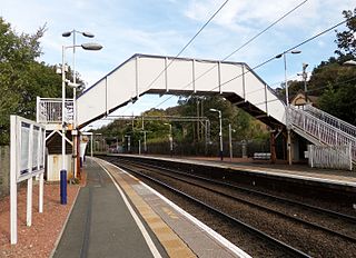
Westerton railway station is a railway station that serves the Westerton district in the town of Bearsden, Scotland. The station is managed and served by ScotRail as part of the Strathclyde Partnership for Transport network. It is located on the Argyle and North Clyde lines, between Drumchapel to the west, Bearsden to the north, and Anniesland and Maryhill to the south-east. It is 6 miles 10 chains (9.9 km) west of Glasgow Queen Street, measured via Maryhill.

The Edinburgh–Bathgate line is a railway line in East Central Scotland. It is also known as the Bathgate branch and was originally operated by the Edinburgh and Bathgate Railway. Except for the short section at the original Bathgate terminus, the main line is still in use, with a frequent passenger train service operated by ScotRail.

The Glasgow, Yoker and Clydebank Railway was a railway company that opened in 1882, giving a rail connection to shipyards and other industry that developed in what became Clydebank. At first it was a purely local line, connecting only at Stobcross with the North British Railway, but as industry developed in the area it served it became increasingly important.

The Stobcross Railway was a railway line in Glasgow, Scotland, built by the North British Railway to connect from Maryhill to the new dock being built at Stobcross; the dock became the Queen's Dock, opened in 1877. The line was opened first, in 1874, and gave the North British company access to the north bank of the River Clyde; there was a goods depot at Partick.

The Whiteinch Railway was a railway line opened in 1874 in Scotland to connect industrial premises that had developed in the area with the Stobcross Railway, giving access to the main line network. It was opened for goods and mineral traffic, and was extended by the Whiteinch Tramway which fed directly into the factories and works.

<span class="mw-page-title-main">Hillfoot railway station</span> Railway station in East Dunbartonshire, Scotland

Hillfoot railway station is a railway station in Bearsden, East Dunbartonshire near Glasgow, Scotland. The station is managed by ScotRail and is served by their trains on the Argyle and North Clyde Lines. It is sited between Milngavie and Bearsden, 7 miles 66 chains (12.6 km) from Glasgow Queen Street, measured via Maryhill.

<span class="mw-page-title-main">Bearsden railway station</span> Railway station in East Dunbartonshire, Scotland

Bearsden railway station serves Bearsden, East Dunbartonshire near Glasgow, Scotland. The railway station is managed by ScotRail and lies on the Argyle Line and North Clyde Lines. It is located between Westerton and Hillfoot on the line to Milngavie, and is 7 miles 21 chains (11.7 km) from Glasgow Queen Street, measured via Maryhill.

The Glasgow Central Railway was a railway line built in Glasgow, Scotland by the Caledonian Railway, running in tunnel east to west through the city centre. It was opened in stages from 1894 and opened up new journey opportunities for passengers and enabled the Caledonian Railway to access docks and industrial locations on the north bank of the River Clyde. An intensive and popular train service was operated, but the long tunnel sections with frequent steam trains were smoky and heartily disliked.

The Symington, Biggar and Broughton Railway was a railway company in southern Scotland. It built a line connecting Biggar, and later Peebles, to the main line railway at Symington. It was taken over by the Caledonian Railway in 1861, and was completed in 1864.

The Glasgow City and District Railway was a sub-surface railway line in Glasgow, Scotland, built to connect suburban routes east and west of the city, and to relieve congestion at the Queen Street terminus.

The Alloa Railway was intended to bridge the River Forth linking Alloa with the south without using a ferry.

The Caledonian and Dumbartonshire Junction Railway (C&DJR) was a Scottish railway opened in 1850 between Bowling and Balloch via Dumbarton. The company had intended to build to Glasgow but it could not raise the money.

The Glasgow, Dumbarton and Helensburgh Railway was independently sponsored to build along the north of the River Clyde. It opened in 1858, joining with an earlier local line serving Balloch. Both were taken over by the powerful North British Railway in 1865, and for some time the line was the main route in the area. As industry developed other lines were opened to serve it, and the line formed the core of a network in the area.

<span class="mw-page-title-main">Coatbridge Branch (NBR)</span>

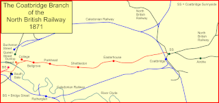
The Coatbridge Branch of the North British Railway was a railway built to connect the important coal and iron industrial districts of Coatbridge and Airdrie directly to Glasgow for the North British Railway.

The Kilsyth and Bonnybridge Railway was a railway line in central Scotland, built to exploit the mineral extractive industries in the area; it opened in 1888. A passenger service was run, but bus competition overwhelmed it after 1920 and the passenger service closed in 1935. The goods and mineral traffic continued, but it was dependent on the industries it served, and when they declined so did the business on the railway; it closed in 1964 and none of it is now in railway use.

References

  1. Carter, E F (1959). An Historical Geography of the Railways of the British Isles. London: Cassell.
  2. The Sessional Papers of the House of Lords. Vol. LVIII, Tables and Indexes. p. 220.
  3. Bradshaw's Railway Manual, Shareholders' Guide and Official Directory. 1867. p. 102.
  4. 1 2 Thomas, John (1984). A Regional History of the Railways of Great Britain. Vol. 6, Scotland, the Lowlands and the Borders. revised by J S Paterson. Newton Abbot: David and Charles. ISBN   0-946537-12-7.
  5. 1 2 3 Stansfield, Gordon (2003). Glasgow and Dunbartonshire's Lost Railways. Catrine: Stenlake Publishing Limited. ISBN   978-184-033-235-3.
  6. 1 2 Ross, David (2014). The North British Railway: A History. Catrine: Stenlake Publishing Limited. ISBN   978-1-84033-647-4.
  7. Smith, W A C; Anderson, Paul (1993). An Illustrated History of Glasgow's Railways. Caernarfon: Irwell Press. ISBN   1-871608-33-3.
  8. 1 2 Thwaite, Malcolm (2005). "The George Bennie Railplane and Hugh Fraser Airrail Systems of Transport". Transactions of the Newcomen Society. 75 (1): 37–84. ISSN   0372-0187.
  9. Noble, Stewart (2010). The Vanished Railways of Old Western Dunbartonshire. Stroud: The History Press. ISBN   978-0-7509-5096-1.
  10. Quick, M E (2002). Railway Passenger Stations in England Scotland and Wales—A Chronology. The Railway and Canal Historical Society.
  11. Network Rail. Scotland Route Sectional Appendix.[ full citation needed ]