Related Research Articles

Orogeny is a mountain-building process that takes place at a convergent plate margin when plate motion compresses the margin. An orogenic belt or orogen develops as the compressed plate crumples and is uplifted to form one or more mountain ranges. This involves a series of geological processes collectively called orogenesis. These include both structural deformation of existing continental crust and the creation of new continental crust through volcanism. Magma rising in the orogen carries less dense material upwards while leaving more dense material behind, resulting in compositional differentiation of Earth's lithosphere. A synorogenic process or event is one that occurs during an orogeny.

A lithosphere is the rigid, outermost rocky shell of a terrestrial planet or natural satellite. On Earth, it is composed of the crust and the lithospheric mantle, the topmost portion of the upper mantle that behaves elastically on time scales of up to thousands of years or more. The crust and upper mantle are distinguished on the basis of chemistry and mineralogy.
Isostasy or isostatic equilibrium is the state of gravitational equilibrium between Earth's crust and mantle such that the crust "floats" at an elevation that depends on its thickness and density. This concept is invoked to explain how different topographic heights can exist at Earth's surface. Although originally defined in terms of continental crust and mantle, it has subsequently been interpreted in terms of lithosphere and asthenosphere, particularly with respect to oceanic island volcanoes, such as the Hawaiian Islands.

The Antarctic Plate is a tectonic plate containing the continent of Antarctica, the Kerguelen Plateau, and some remote islands in the Southern Ocean and other surrounding oceans. After breakup from Gondwana, the Antarctic plate began moving the continent of Antarctica south to its present isolated location, causing the continent to develop a much colder climate. The Antarctic Plate is bounded almost entirely by extensional mid-ocean ridge systems. The adjoining plates are the Nazca Plate, the South American Plate, the African Plate, the Somali Plate, the Indo-Australian Plate, the Pacific Plate, and, across a transform boundary, the Scotia Plate.

Post-glacial rebound is the rise of land masses after the removal of the huge weight of ice sheets during the last glacial period, which had caused isostatic depression. Post-glacial rebound and isostatic depression are phases of glacial isostasy, the deformation of the Earth's crust in response to changes in ice mass distribution. The direct raising effects of post-glacial rebound are readily apparent in parts of Northern Eurasia, Northern America, Patagonia, and Antarctica. However, through the processes of ocean siphoning and continental levering, the effects of post-glacial rebound on sea level are felt globally far from the locations of current and former ice sheets.
The gravity anomaly at a location on the Earth's surface is the difference between the observed value of gravity and the value predicted by a theoretical model. If the Earth were an ideal oblate spheroid of uniform density, then the gravity measured at every point on its surface would be given precisely by a simple algebraic expression. However, the Earth has a rugged surface and non-uniform composition, which distorts its gravitational field. The theoretical value of gravity can be corrected for altitude and the effects of nearby terrain, but it usually still differs slightly from the measured value. This gravity anomaly can reveal the presence of subsurface structures of unusual density. For example, a mass of dense ore below the surface will give a positive anomaly due to the increased gravitational attraction of the ore.
Tectonic uplift is the geologic uplift of Earth's surface that is attributed to plate tectonics. While isostatic response is important, an increase in the mean elevation of a region can only occur in response to tectonic processes of crustal thickening, changes in the density distribution of the crust and underlying mantle, and flexural support due to the bending of rigid lithosphere.

The Iceland hotspot is a hotspot which is partly responsible for the high volcanic activity which has formed the Iceland Plateau and the island of Iceland. It contributes to understanding the geological deformation of Iceland.

A mid-ocean ridge (MOR) is a seafloor mountain system formed by plate tectonics. It typically has a depth of about 2,600 meters (8,500 ft) and rises about 2,000 meters (6,600 ft) above the deepest portion of an ocean basin. This feature is where seafloor spreading takes place along a divergent plate boundary. The rate of seafloor spreading determines the morphology of the crest of the mid-ocean ridge and its width in an ocean basin.
The African superswell is a region including the Southern and Eastern African plateaus and the Southeastern Atlantic basin where exceptional tectonic uplift has occurred, resulting in terrain much higher than its surroundings. The average elevation of cratons is about 400–500 meters above sea level. Southern Africa exceeds these elevations by more than 500 m, and stands at over 1 km above sea level. The Southern and Eastern African plateaus show similar uplift histories, allowing them to be considered as one topographic unit. When considered this way, the swell is one of the largest topographic anomalies observed on any continent, and spans an area of over 10 million km2. Uplift extends beyond the continents into the Atlantic Ocean, where extremely shallow ocean depths are visible through bathymetric survey. The region can indeed be considered as one large swell because the bathymetric anomaly to the southwest of Africa is on the same order as the topographic anomaly of the plateaus.

Mantle convection is the very slow creep of Earth's solid silicate mantle as convection currents carry heat from the interior to the planet's surface. Mantle convection causes tectonic plates to move around the Earth's surface.
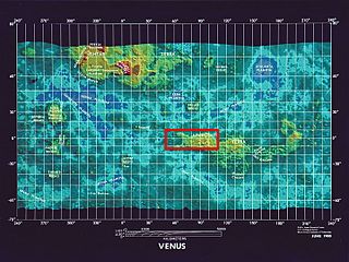
Ovda Regio is a Venusian crustal plateau located near the equator in the western highland region of Aphrodite Terra that stretches from 10°N to 15°S and 50°E to 110°E. Known as the largest crustal plateau in Venus, the regio covers an area of approximately 15,000,000 square kilometres (5,800,000 sq mi) and is bounded by regional plains to the north, Salus Tessera to the west, Thetis Regio to the east, and Kuanja as well as Ix Chel chasmata to the south. The crustal plateau serves as a place to hold the localized tessera terrains in the planet, which makes up roughly 8% of Venus' surface area. The kinematic evolution of crustal plateaus on Venus has been a debated topic in the planetary science community. Understanding its complex evolution is expected to contribute to a better knowledge of the geodynamic history of Venus. It is named after a Marijian forest spirit that can appear as both male and female.

The interaction between erosion and tectonics has been a topic of debate since the early 1990s. While the tectonic effects on surface processes such as erosion have long been recognized, the opposite has only recently been addressed. The primary questions surrounding this topic are what types of interactions exist between erosion and tectonics and what are the implications of these interactions. While this is still a matter of debate, one thing is clear, Earth's landscape is a product of two factors: tectonics, which can create topography and maintain relief through surface and rock uplift, and climate, which mediates the erosional processes that wear away upland areas over time. The interaction of these processes can form, modify, or destroy geomorphic features on Earth's surface.

The Chile Triple Junction is a geologic triple junction located on the seafloor of the Pacific Ocean off Taitao and Tres Montes Peninsula on the southern coast of Chile. Here three tectonic plates meet: the South American Plate, the Nazca Plate and the Antarctic Plate. This triple junction is unusual in that it consists of a mid-oceanic ridge, the Chile Rise, being subducted under the South American Plate at the Peru–Chile Trench. The Chile Triple Junction is the boundary between the Chilean Rise and the Chilean margin, where the Nazca, Antarctic, and South American plates meet at the trench.

Large low-shear-velocity provinces (LLSVPs), also called large low-velocity provinces (LLVPs) or superplumes, are characteristic structures of parts of the lowermost mantle, the region surrounding the outer core deep inside the Earth. These provinces are characterized by slow shear wave velocities and were discovered by seismic tomography of deep Earth. There are two main provinces: the African LLSVP and the Pacific LLSVP, both extending laterally for thousands of kilometers and possibly up to 1,000 kilometres vertically from the core–mantle boundary. These have been named Tuzo and Jason respectively, after Tuzo Wilson and W. Jason Morgan, two geologists acclaimed in the field of plate tectonics. The Pacific LLSVP is 3,000 kilometers across and underlies four hotspots on Earth's crust that suggest multiple mantle plumes underneath. These zones represent around 8% of the volume of the mantle, or 6% of the entire Earth.
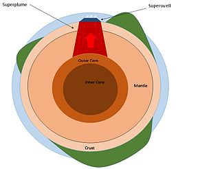
A superswell is a large area of anomalously high topography and shallow ocean regions. These areas of anomalous topography are byproducts of large upwelling of mantle material from the core–mantle boundary, referred to as superplumes. Two present day superswells have been identified: the African superswell and the South Pacific superswell. In addition to these, the Darwin Rise in the south central Pacific Ocean is thought to be a paleosuperswell, showing evidence of being uplifted compared to surrounding ancient ocean topography.

The lithosphere–asthenosphere boundary represents a mechanical difference between layers in Earth's inner structure. Earth's inner structure can be described both chemically and mechanically. The lithosphere–asthenosphere boundary lies between Earth's cooler, rigid lithosphere and the warmer, ductile asthenosphere. The actual depth of the boundary is still a topic of debate and study, although it is known to vary according to the environment.

A tessera is a region of heavily deformed terrain on Venus, characterized by two or more intersecting tectonic elements, high topography, and subsequent high radar backscatter. Tesserae often represent the oldest material at any given location and are among the most tectonically deformed terrains on Venus's surface. Diverse types of tessera terrain exist. It is not currently clear if this is due to a variety in the interactions of Venus's mantle with regional crustal or lithospheric stresses, or if these diverse terrains represent different locations in the timeline of crustal plateau formation and fall. Multiple models of tessera formation exist and further extensive studies of Venus's surface are necessary to fully understand this complex terrain.
Ridge push is a proposed driving force for plate motion in plate tectonics that occurs at mid-ocean ridges as the result of the rigid lithosphere sliding down the hot, raised asthenosphere below mid-ocean ridges. Although it is called ridge push, the term is somewhat misleading; it is actually a body force that acts throughout an ocean plate, not just at the ridge, as a result of gravitational pull. The name comes from earlier models of plate tectonics in which ridge push was primarily ascribed to upwelling magma at mid-ocean ridges pushing or wedging the plates apart.

Earth system interactions across mountain belts are interactions between processes occurring in the different systems or "spheres" of the Earth, as these influence and respond to each other through time. Earth system interactions involve processes occurring at the atomic to planetary scale which create linear and non-linear feedback(s) involving multiple Earth systems. This complexity makes modelling Earth system interactions difficult because it can be unclear how processes of different scales within the Earth interact to produce larger scale processes which collectively represent the dynamics of the Earth as an intricate interactive adaptive system.
References
- 1 2 3 4 Hager, B. H.; Richards, M. A. (1989). "Long-Wavelength Variations in Earth's Geoid: Physical Models and Dynamical Implications". Philosophical Transactions of the Royal Society A: Mathematical, Physical and Engineering Sciences . 328 (1599): 309–327. Bibcode:1989RSPTA.328..309H. doi:10.1098/rsta.1989.0038. S2CID 58937371.
- ↑ Davies, D. R.; Valentine, A. P.; Kramer, S. C.; Rawlinson, N.; Hoggard, M. J.; Eakin, C. M.; Wilson, C. R. (October 2019). "Earth's multi-scale topographic response to global mantle flow". Nature Geoscience. 12 (10): 845–850. Bibcode:2019NatGe..12..845D. doi:10.1038/s41561-019-0441-4. ISSN 1752-0908.
- ↑ Lithgow-Bertelloni, Carolina; Silver, Paul G. (1998). "Dynamic topography, plate driving forces and the African superswell". Nature . 395 (6699): 269–272. Bibcode:1998Natur.395..269L. doi:10.1038/26212. S2CID 4414115.
- ↑ Davies, D.R.; Ghelichkhan, S.; Hoggard, M.J.; Valentine, A.P.; Richards, F.D. (2023), "Observations and Models of Dynamic Topography: Current Status and Future Directions", Dynamics of Plate Tectonics and Mantle Convection, Elsevier, pp. 223–269, doi:10.1016/b978-0-323-85733-8.00017-2, ISBN 978-0-323-85733-8 , retrieved 2024-04-09
- ↑ Robert, X.; Moucha, R.; Whipple, K.X.; Forte, A.M.; Reiners, P.W. (2011). "Cenozoic Evolution of the Grand Canyon and the Colorado Plateau Driven by Mantle Dynamics?". CREvolution 2 - Origin and evolution of the Colorado River system (Report). Vol. 1210. U.S. Geological Survey open-file Report. pp. 238–244.
- ↑ Pedoja, Kevin; Regard, Vincent; Husson, Laurent; Martinod, Joseph; Guillaume, Benjamin; Fucks, Enrique; Iglesias, Maximiliano; Weill, Pierre (2011). "Uplift of quaternary shorelines in eastern Patagonia: Darwin revisited". Geomorphology . 127 (3–4): 121–142. Bibcode:2011Geomo.127..121P. doi:10.1016/j.geomorph.2010.08.003. S2CID 55240986.
- ↑ Guillame, Benjamin; Martinod, Joseph; Husson, Laurent; Roddaz, Martin; Riquelme, Rodrigo (2009). "Neogene uplift of central eastern Patagonia: Dynamic response to active spreading ridge subduction?". Tectonics . 28.
- ↑ Braun, J.; Robert, X.; Simon-Labric, T. (2013). "Eroding dynamic topography". Geophysical Research Letters. 40 (8): 1494–1499. Bibcode:2013GeoRL..40.1494B. doi: 10.1002/grl.50310 .
- ↑ Guillaume, Benjamin; Gautheron, Cécile; Simon-Labric, Thibaud; Martinod, Joseph; Roddaz, Martin; Douville, Eric (2013). "Dynamic topography control on Patagonian relief evolution as inferred from low temperature thermochronology". Earth and Planetary Science Letters. 3: 157–167. Bibcode:2013E&PSL.364..157G. doi:10.1016/j.epsl.2012.12.036.
- Hager, Bradford H.; Clayton, Robert W.; Richards, Mark A.; Comer, Robert P.; Dziewonski, Adam M. (1985). "Lower mantle heterogeneity, dynamic topography and the geoid". Nature . 313 (6003): 541–545. Bibcode:1985Natur.313..541H. doi:10.1038/313541a0. hdl: 2060/19840018116 . S2CID 4326364.