Dysart and Ruan

Last updated

Dysart and Ruan
Catholic parish
Dysert O Dea Doorway.jpg
Doorway of St. Tola's Church
Ireland adm location map.svg
Red pog.svg
Dysart and Ruan
Location in Ireland
Coordinates: 52°55′45″N8°59′25″W / 52.92926°N 8.990326°W / 52.92926; -8.990326 Coordinates: 52°55′45″N8°59′25″W / 52.92926°N 8.990326°W / 52.92926; -8.990326
Country Ireland
Province Munster
County County Clare
Time zone UTC+0 (WET)
  Summer (DST) UTC-1 (IST (WEST))
Irish Grid Reference R330871
Website www.ruan.gaa.ie/sports/home

Dysart and Ruan is a Catholic parish in County Clare, Ireland. It covers the civil parishes of Ruan and Dysert, and includes the village of Ruan, which holds the parish office. The parish contains the ruins of the 12th century St. Tola's Church, part of Dysert O'Dea Monastery.

Contents

Location

The parish lies to the north of Ennis on the road to Corofin. The River Fergus runs through most of the parish, through Tedane and other lakes, to Clarecastle. In 1837 there were police stations in Dysert and Ruan, and chapels in each place. The chapel in Ruan had been rebuilt by public subscription in 1834. [1] The parish includes the civil parishes of Ruan and Dysert. [2] Dysert is sometimes called Dysert O'Dea, since it was part of the territory of the O'Dea sept. [1] Ruan is near the Burren and between Corofin, Crusheen and Ennis. The name "Ruan" (An Ruadhán) is an old Irish term for the alder tree, at one time used to make red dye. [3]

Antiquities

Dysert O'Dea Church

The ruined Church of Disert consists of a nave 71 by 24 feet (21.6 by 7.3 m) and a choir 25.5 by 21.3 feet (7.8 by 6.5 m). It was described by Eugene Curry in 1839. At that time the walls were in perfect condition, about 14 feet (4.3 m) high and 3.1 feet (0.94 m) thick. The west gable has a window, completely covered in ivy inside and out. In the south wall at a distance of 13.8 feet (4.2 m) from the west gable there is a beautifully sculpted door 6.8 feet (2.1 m) high and 3.2 feet (0.98 m) wide. The door has four circular arches, one over the other, resting on columns at the sides of the door. The columns are surmounted by human heads. The largest arch has nineteen stones that project a small way from the wall. They are carved with twelve human and seven animal heads. [4]

The choir in 1839 had a beautiful circular arch built with finely cut grit-stone, about 14.5 feet (4.4 m) wide and the same height. The gable had a double-headed curvilinear pointed belfry. There were pointed windows in the north wall of nave and in the south side of quire near the east gable. The window in the east gable was 11.2 feet (3.4 m) wide and about 15 feet (4.6 m) high, divided into three compartments by two triangular pillars of masonry and lined all round with the same sort of cut stones as those in the choir arch, but looking somewhat fresher. According to tradition the choir was added to the Church by O'Dea. [4]

White Cross of Tola

White Cross of Tola St Tola's White Cross.jpg
White Cross of Tola

About a mile east of the Church of Disert there is a deserted burying ground, near the old chapel, called Mainistir-na-Sratha-Duibhe (Monastery of the Black Sward). There is a Holy Well near it called Tobar Oireachta at which Stations were still performed in 1839. Nearby to the north is a small elevated spot called Cnocan-na-Croise (Height of the Cross), on which a Celtic cross was erected. Part of the shaft remained standing in 1839 about 2 feet (0.61 m) high. [5] The ancient cross lay on the ground. [1]

The cross was re-erected in 1871 by Francis Hutcheson Synge of Dysert. [6] The shaft of the cross is 6.2 by 2.1 feet (1.89 by 0.64 m) and the head is 3.5 feet (1.1 m) high. The north and south sides of the cross are cut into patterns. The north side includes a crude carving of two men swearing on a staff between another man and a bishop. The west side has two heads, but otherwise the carvings have been broken off. The east side has a figure of Christ, with outstretched arms. Below that is a large figure of Saint Tola of Clonard, the Bishop of Clonard and the founder and patron of the Dysert church. Tola died between 733 and 737. [6]

Ruan Church

The ruined Church of Ruan stands in the Ruan townland of the Ruan civil parish. It is 55.3 by 19.5 feet (16.9 by 5.9 m) in area. As of 1839 the walls stood at their original height apart from the west gable, the top of which is broken off. There was a pointed doorway in the south side near the west gable, and a square one in the same side near the east gable. There is a double pointed window in the east gable, but its mullion is gone. There is a portion of the north wall elevated six feet above the rest, as if for the purpose of a ball-alley. There is a little Chapel projecting to the south from the south west angle, nineteen feet six inches long and sixteen feet three inches broad having a pointed door in its east side and elevated tomb in its north end, with a monumental stone over it in the Church wall, exhibiting the following inscription: "This Chapel and tomb were erected by Donogh O’Kerine, the son of Dermot O’Kerine of Owan, for him and his posterities’ use in the year of our Lord God, 1688." [5] There is no patron saint associated with this church, and no holy well dedicated to any particular saint nearby. The only holy wells in the area were named after the townlands. [7]

Today

Dysart and Ruan is a parish in the Roman Catholic Diocese of Killaloe. The parish office is in the village of Ruan. [8] The parish churches are St Mary's in Ruan and St Tola in Dysart. [9] The parish runs two primary schools, Ruan National School and Toonagh National School.[ citation needed ] The parish is home to the Ruan GAA, a Gaelic Athletic Association club, which fields teams in Hurling and Camogie competitions. [10]

The church of St. Marys in Ruan was built in 1912. It replaced the 1834 church. The stained glass windows behind the altar that were made by Franz Mayer & Co. of Munich, Germany. They were formerly in the chapel of St. Xaviers Convent of Mercy in Ennis, and were moved to Ruan in the 1990s when the convent was closed. The window on the left shows the Nativity. That in the center is the Sacred Heart, and includes sheaves of wheat, grapes and a chalice, symbols of the consecration. The window on the right depicts life in the house of the Holy Family. Mary is working on the loom and Joseph is working on carpentry with Jesus by his side. [7]

Related Research Articles

County Clare County in Ireland

County Clare is a county in Ireland, in the Mid-West Region and the province of Munster, bordered on the west by the Atlantic Ocean. Clare County Council is the local authority. The county had a population of 118,817 at the 2016 census. The county town and largest settlement is Ennis.

Inagh Village in Munster, Ireland

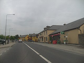
Inagh is a village and civil parish in County Clare, Ireland. It is situated 14 km west of Ennis on the Inagh River. It contains the villages of Inagh and Cloonanaha.

ODea Castle Fortified tower house in Ireland

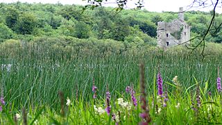
O'Dea Castle, also known as Dysert O'Dea Castle, is an Irish fortified tower house, loosely described as a castle at Dysert O'Dea, the former O'Dea clan stronghold, 5 kilometres (3 mi) from Corofin, County Clare just off the R476 road. It was built between 1470 and 1490 by Diarmaid O'Dea, Lord of Cineal Fearmaic, and stands some 50 feet (15 m) high on a limestone outcrop base measuring 20 by 40 feet. The tower is adjacent to Dysert O'Dea Monastery.

Corofin, County Clare Town in Munster, Ireland

Corofin is a village on the River Fergus in northern County Clare in Ireland and a Catholic parish with the same name.

O'Dea, is an Irish surname derived from Deághaidh, the name of a tenth-century clan chieftain.

Dysert ODea Monastery 12th century Irish church

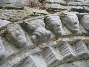
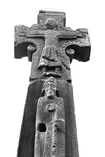
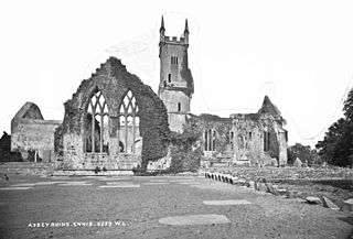
Dysert O'Dea Church near Corofin in County Clare, Ireland stands on the site of an early Christian monastery which was reportedly founded by St. Tola in the 8th century. Most of the present structures are from the 12th century.

Tola of Clonard

Saint Tola is the name of a seventh-century Irish Roman Catholic saint, also referred to as "a good soldier of Christ".

Kilnamona Civil parish and village in Munster, Ireland

Kilnamona is a village and a civil parish in County Clare, Ireland. It is situated north-west of Ennis.

Tubber, County Clare Village in Munster, Ireland

Tubber is a village in the north of County Clare, Ireland.

Sixmilebridge Town in Munster, Ireland

Sixmilebridge, colloquially The Bridge, is a small town in County Clare, Ireland. Located midway between Ennis and Limerick city, the town is a short distance away from the main N18 road, being located on the old "back road" between the two. The village of Kilmurry is also part of the Sixmilebridge parish.

Ruan, County Clare Village in Munster, Ireland

Ruan is a village in County Clare in Ireland and a civil parish by the same name. It is in the Catholic parish of Dysart and Ruan.

Dysert, County Clare Civil parish in County Clare, Ireland

Dysert is a civil parish in County Clare, Ireland. The parish was formerly called Dysert O’Dea, from its having been the territory of the sept of that name. It is part of the ecclesiastical parish of Dysart and Ruan. The ruins of O'Dea Castle and a 12th-century church of Dysert O'Dea Monastery are in the townland of the same name.

Drumcliff, County Clare Civil parish in Munster, Ireland

Drumcliff, or Drumcliffe, Dromcliffe is a civil parish in County Clare, Ireland. It includes the village of Inch and part of the town of Ennis.

Tomfinlough Civil parish in Clare, Ireland

Tomfinlough is a civil parish in County Clare, Ireland. A Christian establishment was first made here around 540 AD. The parish lands were often raided by Irish, Viking, Norman and English forces in the years that followed. The church was allowed to fall into ruins during the period when the Catholic Church was penalized in Ireland.

Killokennedy Civil parish in Munster, Ireland

Killokennedy is a civil parish in County Clare, Ireland.

Crusheen (Inchicronan) Parish in Munster, Ireland

Crusheen, formerly called Inchicronan, is a Catholic parish in County Clare, Ireland. Inchicronan is also a civil parish, covering the same area. The parish lies to the northeast of Ennis. It contains the village of Crusheen and the ruin of Inchicronan Priory, built in 1190.

Gleninagh Parish in Munster, Ireland

Gleninagh or Glaninagh is a civil parish in County Clare, Ireland. It lies in the extreme northwest of the Burren, on the south of the mouth of Galway Bay. It is known for the well-preserved L-plan Gleninagh Castle, a 16th-century tower house. The parish also contains the lighthouse on Black Head.

Inagh and Kilnamona Catholic Parish in Munster, Ireland

Inagh and Kilnamona is a parish of the Roman Catholic Diocese of Killaloe in County Clare, Ireland. It is mostly coterminous with the civil parishes of Inagh and Kilnamona that lie to the west of the county town of Ennis in the ancient barony of Inchiquin. The parish contains two churches and an oratory. Inagh-Kilnamona GAA club is situated in the eastern part of the parish.

Doora Church Church in Ireland

Doora Church, also known as St Brecan, Doora, is a ruined church in the civil parish of Doora, County Clare, Ireland. It may date back to 500 AD, although it has been extensively reworked since then.

References

  1. 1 2 3 Lewis 1840, p. 593.
  2. Ruan Parish, Clare County Library.
  3. Ruan Historical Background.
  4. 1 2 Curry 1839.
  5. 1 2 O'Donovan & Curry 1839.
  6. 1 2 Westropp 1894.
  7. 1 2 Ruan Places of Interest, Clare County Library.
  8. Dysart & Ruan, Killaloe Diocese.
  9. Dysart & Ruan, Churches.
  10. Home, Ruan GAA.

Sources