East Brewton, Alabama

Last updated

East Brewton
Escambia County Alabama Incorporated and Unincorporated areas East Brewton Highlighted 0122216.svg
Location of East Brewton in Escambia County, Alabama.
Coordinates: 31°5′32″N87°3′11″W / 31.09222°N 87.05306°W / 31.09222; -87.05306
Country United States
State Alabama
County Escambia
Government
  MayorTerry Clark
Area
[1]
  Total3.44 sq mi (8.92 km2)
  Land3.41 sq mi (8.83 km2)
  Water0.04 sq mi (0.09 km2)
Elevation
98 ft (30 m)
Population
 (2020)
  Total2,293
  Density672.83/sq mi (259.79/km2)
Time zone UTC-6 (Central (CST))
  Summer (DST) UTC-5 (CDT)
ZIP code
36426-36427
Area code 251
FIPS code 01-22216
GNIS feature ID0117739
Website eastbrewton.org

East Brewton is a city in Escambia County, Alabama, United States. It was incorporated in October 1918. [2] At the 2020 census, the population was 2,293. The community grew around Fort Crawford, a fort built to protect early settlers of the area. [3]

Contents

Geography

East Brewton is located in east-central Escambia County at 31°5′33″N87°3′11″W / 31.09250°N 87.05306°W / 31.09250; -87.05306 (31.092408, -87.053174). [4] It is bordered to the northwest by the city of Brewton, across Murder Creek.

U.S. Route 29 and Alabama State Route 41 pass through the center of East Brewton as Forrest Avenue and lead northwest into the center of Brewton. In the other direction, US 29 runs east, then northeast, 44 miles (71 km) to Andalusia, while AL 41 leads south 7 miles (11 km) to the Florida line. Milton, Florida, is 34 miles (55 km) south of East Brewton via AL 41 and Florida State Road 87.

According to the U.S. Census Bureau, East Brewton has a total area of 3.4 square miles (8.9 km2), of which 3.4 square miles (8.8 km2) is land and 0.04 square miles (0.1 km2), or 1.02%, is water. [5]

Demographics

Historical population
CensusPop.Note
1920 826
1930 1,00221.3%
1940 1,34033.7%
1950 2,17362.2%
1960 2,51115.6%
1970 2,336−7.0%
1980 3,01228.9%
1990 2,579−14.4%
2000 2,496−3.2%
2010 2,478−0.7%
2020 2,293−7.5%
U.S. Decennial Census [6]

As of the census [7] of 2000, there were 2,496 people, 1,043 household, and 688 families residing in the city. The population density was 712.3 inhabitants per square mile (275.0/km2). There were 1249 housing units at an average density of 356.4 per square mile (137.6/km2). The racial makeup of the city was 77.07% White, 10.29% Black or African American, 10.48% Native American, 0.08% Pacific Islander, 1.44% from other races, and 0.64% from two or more races. 1.96% of the population were Hispanic or Latino of any race.

There were 1,043 households, out of which 31.6% had children under the age of 18 living with them, 46.4% were married couples living together, 15.3% had a female householder with no husband present, and 34.0% were non-families. 29.9% of all households were made up of individuals, and 12.2% had someone living alone who was 65 years of age or older. The average household size was 2.39 and the average family size was 2.94.

The median income for a household in the city was $23,125, and the median income for a family was $30,610. Males had a median income of $22,138 versus $12,540 for females. The per capita income for the city was $12,531. About 18.5% of families were above the poverty line, including 36.7% of those under age 18 and 22.0% of those age 65 or over.

2010 census

As of the census [8] of 2010, there were 2,478 people, 992 household, and 661 families residing in the city. The population density was 708 inhabitants per square mile (273/km2). There were 1,226 housing units at an average density of 350.3 per square mile (135.3/km2). The racial makeup of the city was 74.7% White, 20.8% Black or African American, .6% Native American, 0.0% Pacific Islander, 2.6% from other races, and 1.3% from two or more races. 3.1% of the population were Hispanic or Latino of any race.

There were 992 households, out of which 31.0% had children under the age of 18 living with them, 37.6% were married couples living together, 23.6% had a female householder with no husband present, and 33.4% were non-families. 28.5% of all households were made up of individuals, and 12.0% had someone living alone who was 65 years of age or older. The average household size was 2.50 and the average family size was 3.03.

The median income for a household in the city was $26,065, and the median income for a family was $34,120. Males had a median income of $35,833 versus $17,458 for females. The per capita income for the city was $15,181. About 26.4% of families and 29.7% of the population were above the poverty line, including 39.1% of those under age 18 and 13.1% of those age 65 or over.

Education

Escambia County Public School System is the local school district. [9]

Related Research Articles

<span class="mw-page-title-main">Santa Rosa County, Florida</span> County in Florida, United States

Santa Rosa County is a county located in the northwestern portion of the U.S. state of Florida. As of 2020, the population is 188,000. The county seat is Milton, which lies in the geographic center of the county. Other major communities within Santa Rosa County are Navarre, Pace, and Gulf Breeze. Navarre is the most populated community with a population of approximately 45,000 residents. Santa Rosa County is included in the Pensacola Metropolitan Statistical Area, which also includes Escambia County.

<span class="mw-page-title-main">Escambia County, Alabama</span> County in Alabama, United States

Escambia County is a county located in the south central portion of the U.S. state of Alabama. As of the 2020 census, the population was 36,757. Its county seat is Brewton.

<span class="mw-page-title-main">Jackson, Alabama</span> City in Alabama, United States

Jackson is a city in Clarke County, Alabama, United States. The population was 5,557 at the 2020 census. It was one of three wet settlements in an otherwise-dry county.

<span class="mw-page-title-main">Repton, Alabama</span> Town in Alabama, United States

Repton is a town in Conecuh County, Alabama, United States. It was incorporated on January 10, 1899. At the 2020 census, the population was 235.

<span class="mw-page-title-main">Good Hope, Alabama</span> City in Alabama, United States

Good Hope is a city in Cullman County, Alabama, United States. As of the 2010 census, the population of the city was 2,264. It incorporated in April 1962.

<span class="mw-page-title-main">Brewton, Alabama</span> City in and county seat of Escambia County, Alabama

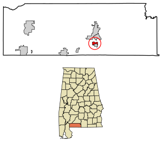
Brewton is a city in and the county seat of Escambia County, Alabama, United States. As of the 2020 census, the population was 5,276. Brewton is located in south central Alabama, just north of the Florida Panhandle.

<span class="mw-page-title-main">Flomaton, Alabama</span> Town in Alabama, United States

Flomaton is a town in Escambia County, Alabama, United States. At the 2010 census the town's population was 1,440. It is located next to the Alabama / Florida state line.

<span class="mw-page-title-main">Pollard, Alabama</span> Town in Alabama, United States

Pollard is a town in Escambia County, Alabama, United States. It was the first established county seat of Escambia County, from its creation in 1868 until 1883, when it lost that distinction to Brewton. At the 2020 census, the population was 128.

<span class="mw-page-title-main">Riverview, Alabama</span> Town in Alabama, United States

Riverview is a town in Escambia County, Alabama, United States. At the 2010 census the population was 184, up from 99 at the 2000 census.

<span class="mw-page-title-main">Monroeville, Alabama</span> City in Alabama

Monroeville is the county seat of Monroe County, Alabama, United States. At the 2020 census its population was 5,951.

<span class="mw-page-title-main">Oakman, Alabama</span> Town in Alabama, United States

Oakman is a town in Walker County, Alabama, United States. At the 2020 census the population was 771, down from 789 in 2010. Initially named Day Gap, it was renamed Oakman and incorporated in 1895.

<span class="mw-page-title-main">Brent, Florida</span> Census-designated place in Florida, United States

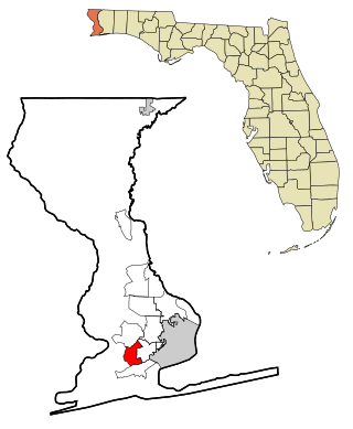
Brent is a census-designated place (CDP) in Escambia County, Florida. It is considered to be a community within Pensacola. The population was 21,804 at the 2010 census. It is a principal area of the Pensacola-Ferry Pass-Brent Metropolitan Statistical Area. The community is named after Francis Celestino Brent, who played an integral role in the development of Pensacola.

<span class="mw-page-title-main">Century, Florida</span> Town in Florida, United States

Century is a town in Escambia County, Florida, United States. Per the 2020 census, the population was 1,713. It is part of the Pensacola–Ferry Pass–Brent Metropolitan Statistical Area.

<span class="mw-page-title-main">Ferry Pass, Florida</span> Census-designated place in Florida, United States

Ferry Pass is a census-designated place (CDP) in Escambia County, Florida. It is a community in Pensacola, and is located north of Pensacola City Limits. As of the 2010 United States Census, the population was 28,921. The University of West Florida, located in Ferry Pass, is the only university located in the Pensacola Metropolitan Area.

<span class="mw-page-title-main">Molino, Florida</span> Census-designated place in Florida, United States

Molino is a census-designated place (CDP) in Escambia County, Florida, United States. The population was 1,277 at the 2010 census. It is part of the Pensacola–Ferry Pass–Brent Metropolitan Statistical Area.

<span class="mw-page-title-main">Myrtle Grove, Florida</span> Census-designated place in Florida, United States

Myrtle Grove is a census-designated place (CDP) in Escambia County, Florida, United States. The population was 15,870 at the 2010 census. It is part of the Pensacola–Ferry Pass–Brent Metropolitan Statistical Area.

<span class="mw-page-title-main">Warrington, Florida</span> CDP in Florida, United States

Warrington is a census-designated place (CDP) in Escambia County, Florida, United States. Warrington is located between downtown Pensacola and the state line with Alabama; it is 6 miles (10 km) away from both.

<span class="mw-page-title-main">Cottondale, Florida</span> City in Florida, United States

Cottondale is a city in Jackson County, Florida, United States. It is part of the Florida Panhandle and North Florida. The population was 848 at the 2020 census, down from 933 at the 2010 census.

<span class="mw-page-title-main">Jay, Florida</span> Town in the state of Florida, United States

Jay is a town in Santa Rosa County, Florida, United States. The Town of Jay is part of the Pensacola–Ferry Pass–Brent Metropolitan Statistical Area, and located on the Florida Panhandle in North Florida. The population was 524 at the 2020 census.

<span class="mw-page-title-main">New Holstein (town), Wisconsin</span>

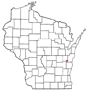
New Holstein is a town in Calumet County in the U.S. state of Wisconsin. The population was 1,508 at the 2010 census. The City of New Holstein is located in the town, but the two are politically independent. The unincorporated communities of Meggers and St. Anna are located partially in the town.

References

  1. "2020 U.S. Gazetteer Files". United States Census Bureau. Retrieved October 29, 2021.
  2. "East Brewton".
  3. Foscue, Virginia (1989). Place Names in Alabama. Tuscaloosa: The University of Alabama Press. p. 50. ISBN   0-8173-0410-X.
  4. "US Gazetteer files: 2010, 2000, and 1990". United States Census Bureau. February 12, 2011. Retrieved April 23, 2011.
  5. "Geographic Identifiers: 2010 Demographic Profile Data (G001): East Brewton city, Alabama". American Factfinder. U.S. Census Bureau. Archived from the original on February 13, 2020. Retrieved January 21, 2016.
  6. "U.S. Decennial Census". Census.gov. Retrieved June 6, 2013.
  7. "U.S. Census website". United States Census Bureau . Retrieved January 31, 2008.
  8. "U.S. Census website". United States Census Bureau . Retrieved July 23, 2015.
  9. "2020 CENSUS - SCHOOL DISTRICT REFERENCE MAP: Escambia County, AL" (PDF). U.S. Census Bureau . Retrieved August 1, 2022. - Text list

31°05′33″N87°03′11″W / 31.092408°N 87.053174°W / 31.092408; -87.053174