The Bahamas, officially the Commonwealth of The Bahamas, is an island country within the Lucayan Archipelago of the Atlantic Ocean. It contains 97% of the Lucayan Archipelago's land area and 88% of its population. The archipelagic country consists of more than 3,000 islands, cays, and islets in the Atlantic Ocean, and is located north of Cuba and northwest of the island of Hispaniola and the Turks and Caicos Islands, southeast of the U.S. state of Florida, and east of the Florida Keys. The capital is Nassau on the island of New Providence. The Royal Bahamas Defence Force describes the Bahamas' territory as encompassing 470,000 km2 (180,000 sq mi) of ocean space.
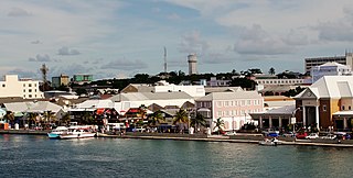
Nassau is the capital and largest city of the Bahamas. It is located on the island of New Providence, which had a population of 246,329 in 2010, or just over 70% of the entire population of the Bahamas. As of April 2023, the preliminary results of the 2022 census of the Bahamas reported a population of 296,522 for New Providence, 74.26% of the country's population. Nassau is commonly defined as a primate city, dwarfing all other towns in the country. It is the centre of commerce, education, law, administration, and media of the country.
New Providence is the most populous island in The Bahamas, containing more than 70% of the total population. On the eastern side of the island is the national capital city of Nassau; it had a population of 246,329 at the 2010 Census, and a population of 292,522 at the 2022 census. Nearly three quarters of The Bahamas's population lives in New Providence.

Andros Island is an archipelago within The Bahamas, the largest of the Bahamian Islands. Politically considered a single island, Andros in total has an area greater than all the other 700 Bahamian islands combined. The land area of Andros consists of hundreds of small islets and cays connected by mangrove estuaries and tidal swamplands, together with three major islands: North Andros, Mangrove Cay, and South Andros. The three main islands are separated by bights, estuaries that trifurcate the island from east to west. It is 167 kilometres (104 mi) long by 64 km (40 mi) wide at the widest point.

Local government in the Bahamas exists at two levels: 32 districts and 41 towns. The boundaries of districts are defined by the First Schedule of The Bahamas Local Government Act 1996, defined with reference to parliamentary constituency boundaries. The Second Schedule lists 13 districts which are divided into town areas. Towns are governed by directly elected town committees. Second Schedule districts are governed by nine-person district councils composed of the chairs of the town committees, and if numerically required, additional people elected by the town committees. The 19 Third Schedule districts are unitary authorities which cannot be divided into towns. They are governed by nine-person district councils which are directly elected by voters. The powers of Second Schedule and Third Schedule councils are slightly different, and the Third Schedule district known as the City of Freeport has a slightly different list of enumerated powers.

The Abaco Islands lie in the north of The Bahamas, about 193 miles east of Miami, Florida, US. The main islands are Great Abaco and Little Abaco, which is just west of Great Abaco's northern tip. There are several smaller barrier cays, of which the northernmost are Walker's Cay and its sister island Grand Cay. To the south, the next inhabited islands are Spanish Cay and Green Turtle Cay, with its settlement of New Plymouth, Great Guana Cay, private Scotland Cay, Man-O-War Cay and Elbow Cay, with its settlement of Hope Town. Southernmost are Tilloo Cay and Lubbers Quarters. Also of note off Abaco's western shore is Gorda Cay, now a Disney-owned island and cruise ship stop renamed Castaway Cay. Also in the vicinity is Moore's Island. On the Big Island of Abaco is Marsh Harbour, the Abacos' commercial hub and The Bahamas' third-largest city, plus the resort area of Treasure Cay. Both have airports. Mainland settlements include Coopers Town and Fox Town in the north and Cherokee and Sandy Point in the south. Administratively, the Abaco Islands constitute seven of the 31 Local Government Districts of The Bahamas: Grand Cay, North Abaco, Green Turtle Cay, Central Abaco, South Abaco, Moore's Island and Hope Town.

Grand Bahama is the northernmost of the islands of The Bahamas, with the town of West End located 56 nautical miles east of Palm Beach, Florida. It is the third largest island in The Bahamas island chain of approximately 700 islands and 2,400 cays. The island is roughly 530 square miles (1,400 km2) in area and approximately 153 kilometres long west to east and 24 kilometres at its widest point north to south. Administratively, the island consists of the Freeport Bonded Area and the districts of East Grand Bahama and West Grand Bahama. Nearly half of the homes on the island were damaged or destroyed in early September 2019 by Hurricane Dorian.

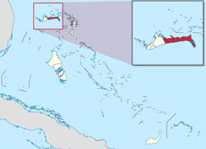
Eleuthera refers both to a single island in the archipelagic state of the Commonwealth of the Bahamas and to its associated group of smaller islands. Eleuthera forms a part of the Great Bahama Bank. The island of Eleuthera incorporates the smaller Harbour Island. "Eleuthera" derives from the feminine form of the Greek adjective ἐλεύθερος (eleútheros), meaning "free". Known in the 17th century as Cigateo, it lies 80 km east of Nassau. It is long and thin—180 km long and in places little more than 1.6 km wide. At its narrowest point, the Glass Window Bridge, which has been called the narrowest place on earth, Eleuthera stands 30 feet wide. Its eastern side faces the Atlantic Ocean and its western side faces the Great Bahama Bank. The topography of the island varies from wide rolling pink sand beaches to large outcrops of ancient coral reefs and the highest elevation point is 200 feet. The population is approximately 11,000 and the principal economy of the island is tourism.

Inagua is the southernmost district of the Bahamas, comprising the islands of Great Inagua and Little Inagua. The headquarters for the district council are in Matthew Town.

Mayaguana is the easternmost island and district of The Bahamas. Its population was 277 in the 2010 census. It has an area of about 280 km2 (110 sq mi).

Ragged Island is a 23 km2 (8.9 sq mi) island and district in the southern Bahamas. Ragged Island is part of the Jumentos Cays and Ragged Island Chain. The crescent-shaped chain measures over 180 km (110 mi) in length and includes cays known as Raccoon Cay, Hog Cay and Double-Breasted Cay. Island ownership is stated to have been granted to William George Lockhart some time in the 18th century. On 8 September 2017, Duncan Town took a direct hit from Hurricane Irma.

West Grand Bahama is one of 31 districts of The Bahamas. The district covers the entire western portion of Grand Bahama island, excluding the city of Freeport, which forms its own district. Communities within West Grand Bahama include the settlements of Mack Town, Hunters, Lewis Yard, Pinder's Point, Eight Mile Rock, Hepburn Town, Bartlett Hill, Hanna Hill, Pine Dale, Martin Town, Russell Town, Jones Town, Sea Grape, Holmes Rock, Bootle Bay and the westernmost settlement of West End.

Grand Cay is one of the districts of the Bahamas. It is geographically located in the Abaco Islands.
Pedro Bank is a large bank of sand and coral, partially covered with seagrass, about 80 km south and south-west of Jamaica, rising steeply from a seabed of 800 m depth.
Freetown is an area in the Bahamas located on the island of Eleuthera. As of 2018, it had a population of about 100.
The following outline is provided as an overview of and topical guide to The Bahamas:

The following is an alphabetical list of topics related to the Commonwealth of The Bahamas.
West End is the oldest town and westernmost settlement on the Bahamian island of Grand Bahama. It is agreed by most academics and lawmakers that West End is the current capital of Grand Bahama, contrary to the popular belief that Freeport City is the capital of the island. Yet however, some lawmakers continue to insist that Freeport City is the legitimate capital of Grand Bahama. It is also the third largest settlement in The Bahamas. There is one airport in West End, West End Airport, which serves mostly private aircraft. Since the 1950s, the settlement of West End has fluctuated with the rise and fall of the adjacent resort developments.
Grand Bahama Aux AF Airport is a public use airport located 9 nm east of Grand Bahama, the Bahamas.
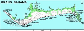
Eight Mile Rock is one of the Grand Bahama island's oldest communities. Eight Mile Rock consist of 11 subsettlements: Hepburn Town, Bartlett Hill, Hanna Hill, Pinedale, Martin Town, Russell Town, Jones Town, Seagrape. Eight Mile Rock is 14 miles from Freeport and the largest settlement outside of Freeport. This area obtained its name from the eight miles of solid rock found along its shore line. Its geographical coordinates are 26° 31' 0" North, 78° 47' 0" West.