Holliston is a New England town in Middlesex County, Massachusetts, United States in the Greater Boston area. The population was 13,547 at the 2010 census, and in 2016, the population was 14,556. It is located in MetroWest, a Massachusetts region that is west of Boston. Holliston is the only town in Middlesex County that borders both Norfolk and Worcester counties.

Massachusetts Avenue is a major diagonal transverse road in Washington, D.C., and the Massachusetts Avenue Historic District is a historic district that includes part of it.

The Ashburnham Center Historic District is a historic district encompassing the core of the village center of Ashburnham, Massachusetts in the United States. It is a well-preserved industrial village that experienced its most significant period of growth in the mid-19th century. The district was added to the National Register of Historic Places in 1999.
The Neponset Valley Parkway is a historic parkway in southern Boston and Milton, Massachusetts, United States. It is a connecting parkway in the Greater Boston area's network, providing a connection between the Blue Hills Reservation, Neponset River Reservation, and the Stony Brook Reservation. The parkway was constructed between 1898 and 1929 with design assistance from Charles Eliot and the Olmsted Brothers. It was listed on the National Register of Historic Places in 2005.

The Branford Point Historic District is a historic district in Branford, Connecticut. It was listed on the National Register of Historic Places in 1988. It includes a significant portion of the Branford Point neighborhood, generally considered to be the area along the west side of the Branford Harbor to the Amtrak railroad tracks. It is bounded on the west by the Short Beach neighborhood, on the north by Branford Center, and on the east by the Branford River. Harbor Street, Maple Avenue, and Stannard Avenue are the main thoroughfares of the neighborhood. In the 2000 Census, Branford Point was included by the U.S. Census Bureau in the Branford Center census-designated place.

The Lower Highlands Historic District encompasses one of the oldest residential areas of Fall River, Massachusetts. The district is roughly bounded by Cherry, Main, Winter, and Bank Streets, and is located just east of the Downtown Fall River Historic District and directly south of the Highlands Historic District. This area was settled by 1810, has architecture tracing the city's growth as a major industrial center. The historic district was added to the National Register of Historic Places in 1984.

The Acushnet Heights Historic District is a predominantly residential historic district in central New Bedford, Massachusetts. It encompasses a densely-built urban area about 20 acres (8.1 ha) in size, which was developed as a working-class area, beginning in the 1860s, for the many workers in the city's factories. The district was listed on the National Register of Historic Places in 1989. It abuts the North Bedford Historic District, which is just to the south, and includes the following separately-listed properties: the Union Street Railway Carbarn, the Bradford Smith Building, and the Dawson Building.

The Cotuit Historic District is a historic district encompassing the heart of the village of Cotuit in Barnstable, Massachusetts. It extends along Main Street from Lowell Street in the north to Sea Street in the south, and includes portions of Ocean View Avenue and properties on adjacent roads. The oldest properties date to the late 18th century, but saw its greatest development during the height of the area's maritime industry in the mid 19th century. In the late 19th and early 20th century the area saw new development as a summer resort area. The district was listed on the National Register of Historic Places in 1987.

The Harwich Historic District is a historic district encompassing the historic portions of the Harwich Center village of Harwich, Massachusetts. The village, originally known as Broadbrooks after a prominent local family, was developed beginning in the 18th century, and features a high quality concentration of Greek Revival and Italianate architecture. It extends along Main and Parallel Streets between the cemetery in the west and Brooks Park in the east. It was listed on the National Register of Historic Places in 1975.

The Charlemont Village Historic District is a historic district on Massachusetts Route 2 between South Street and Harmony Lane, encompassing much of the village center of Charlemont, Massachusetts. The district's properties represent the growth of the village center from its rural origin through a period of 19th century industrialization, including 18th and 19th century farmsteads, Greek Revival buildings of the mid 19th century, and later 19th century Victorian architectural styles. The district was added to the National Register of Historic Places in 1988.
The Northfield Main Street Historic District is a historic district located along the full length of Main Street from Millers Brook to Pauchaug Brook in Northfield, Massachusetts. The district encompasses the part of Main Street that was laid out when Northfield was first established in the 17th century. The area has retained many of its traditional lot divisions, and features civic and residential construction from the 18th to the 20th centuries. The district was listed on the National Register of Historic Places in 1982.
The Elm Street Historic District is a rural historic district in southern Hatfield, Massachusetts. It encompasses a landscape that has seen agricultural use since 17th century colonial days, including fields now used for tobacco farming, and historic properties located along five roads: Elm Street, Scotland Road, Sunset Road, Brook Hollow Road, and Little Neponset Road. The district is bounded on its south by the Connecticut River, on its east and north by the Mill River, with a small portion of land border in the northeast which cuts off a large meander in the river. This section, near the junction of Elm and Prospect Streets, is also where this district abuts the Mill-Prospect Street Historic District, which runs north along Prospect Street, and its eastern boundary abuts the Hatfield Center Historic District. Its western boundary is roughly a north-south line in the area of the junction of Elm and Dwight Streets.
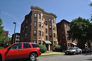
The Belle and Franklin Streets Historic District is a residential historic district encompassing the surviving portions of 1914-16 apartment house development on the northwest side of downtown Springfield, Massachusetts. The properties are at 77—103 Belle St. and 240—298 Franklin Street, and were listed on the National Register of Historic Places in 1989.

The East End Historic District encompasses the historic eastern portion of central Ipswich, Massachusetts. The now predominantly residential district is bounded on the north and west by East Street, running from its junction with North Main and High Streets to Jeffrey's Neck Road. The eastern boundary includes the Ipswich River and Turkey Shore Road from its junction with Labor-in-Vain Road to Green Street, and the southern boundary runs along Green Street to North Main. The district was listed on the National Register of Historic Places in 1980.
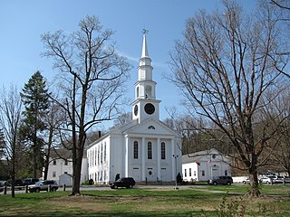
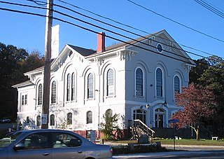
The Thomas Hollis Historic District encompasses the historic civic and commercial heart of Holliston, Massachusetts. It extends along Washington Street (Massachusetts Routes 16 and 126 for about one mile, between Winter Street and Highland Street. Incorporated in 1724, this area now includes a well-preserved collection of predominantly 19th century architecture. The district was listed on the National Register of Historic Places in 1989.

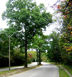
The Kendal Green Historic District is a rural residential district running along North Avenue in Weston, Massachusetts. It extends for about three-quarters of a mile, and includes elements representative of the development of Weston from a rural agricultural community to a residential suburb of Boston. In addition to a variety of predominantly residential and agricultural properties, it includes two formerly industrial sites important in Weston's history: the site of the Hobbs Tannery, and that of the Hook and Hastings Organ Factory. The district was listed on the National Register of Historic Places in 2000.

The Spring Hill Historic District is a historic district roughly bounded by Summer, Central, Atherton, and Spring Streets in the Spring Hill area of Somerville, Massachusetts. The district encompasses the city's best-preserved residential subdivision from the mid-19th century, with later infill construction in the late 19th and early 20th centuries. The district was listed on the National Register of Historic Places in 1989.

West Roxbury Parkway is a historic parkway running from Washington Street in Boston, Massachusetts, where the Enneking Parkway runs south, to Horace James Circle in Brookline, where it meets the Hammond Pond Parkway. The parkway serves as a connector between Stony Brook Reservation and Hammond Pond Reservation. West Roxbury Parkway was built between 1919 and 1929 and added to the National Register of Historic Places in 2006. The parkway is distinctive in the roadway system developed by the Metropolitan District Commission beginning around the turn of the 20th century in that it was built in collaboration with the City of Boston, and is maintained by the city.

The East Leverett Historic District of Leverett, Massachusetts, encompasses the historic mill village of East Leverett. Centered on the intersection of Cushman Road and Shutesbury Road in the southeastern portion of the rural town, it includes predominantly residential buildings that were built during the height of the area's industrial activity in the first four decades of the 19th century. The architecture is mainly Federal and Greek Revival in style. The district was listed on the National Register of Historic Places in 2014.

The Head of the River Historic District is a historic district encompassing a village area at the head of navigation of the Acushnet River, which separates Acushnet and New Bedford, Massachusetts. The village is centered at the junction of Tarkin Hill Road, River Road, and Mill Road in New Bedford, and Main Street in Acushnet. The area went through two significant periods of development: the first was in the late 18th and early 19th century, and the second was in the early 20th century. The district was listed on the National Register of Historic Places in 2009.


