Yell is one of the North Isles of Shetland, Scotland. In the 2011 census it had a usually resident population of 966. It is the second largest island in Shetland after the Mainland with an area of 82 square miles (212 km2), and is the third most populous in the archipelago, after the Mainland and Whalsay.
Papa Stour is one of the Shetland Islands in Scotland, with a population of under fifteen people, some of whom immigrated after an appeal for residents in the 1970s. Located to the west of mainland Shetland and with an area of 828 hectares, Papa Stour is the ninth largest island in Shetland. Erosion of the soft volcanic rocks by the sea has created an extraordinary variety of caves, stacks, arches, blowholes, and cliffs. The island and its surrounding seas harbour diverse populations of wildlife. The west side of the island is a Site of Special Scientific Interest and the seas around the island are a Special Area of Conservation.

Whalsay is the sixth largest of the Shetland Islands in the north of Scotland.
The Out Skerries are an archipelago of islets, some inhabited, in Shetland, Scotland, and are the easternmost part of Shetland. Locally, they are usually called Da Skerries or just Skerries.

Linga is a very small uninhabited island in the Bluemull Sound, Shetland, Scotland. It is one of many islands in Shetland called Linga. It has an area of 45 ha and is 26m at its highest point.

The North Mainland of the Shetland Islands, Scotland is the part of the Mainland lying north of Voe.
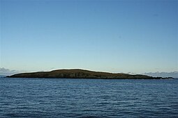
Linga is a small, uninhabited island, 1 km (0.62 mi) east of Muckle Roe in the Shetland Islands. The island is roughly circular in shape and its highest elevation is 69 metres (226 ft). Its area is 70 hectares (0.27 sq mi).

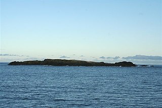
Uyea is an uninhabited tidal island located to the northwest of Mainland, Shetland. Uyea lies off the Northmavine peninsula, from where it can be reached by foot at low tide. The island's highest elevation is 70 metres (230 ft) and its area is 45 hectares (0.17 sq mi).
West Linga is an uninhabited island located between Mainland and Whalsay in Shetland, Scotland.

Grif Skerry is an islet to the east of Whalsay in the Shetland Islands. Its name comes from the Norse or Norn for "deep sea skerry".

Linga is one of the Shetland Islands, in Yell Sound.
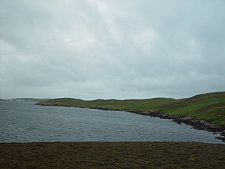
Burrastow is a location on the west shore of Vaila Sound near the village of Walls on the Shetland Mainland, Scotland. There are two small piers and the imposing 18th-century Burrastow House. To the east is the bay of Lera Voe and the two small islets of Holm of Breibister and Holm of Burrastow. To the south is Wester Sound, which lies between the mainland and Vaila. The rocky coast contains numerous caves, geos and skerries. Otters and seals are commonly seen offshore.
Little Linga is a small island in the Shetland Islands. It is near West Linga and Vidlin on Mainland, Shetland. It is 20 metres (66 ft) at its highest point. It measures 500 metres (550 yd) from north to south.

Tarner Island is a triangular shaped island in Loch Bracadale just off the coast off the Harlosh peninsula of Skye in Scotland. It is about 28 hectares in extent and is 0.65 miles at its longest by 0.33 miles at its widest

Brough is a settlement in western Whalsay in the parish of Nesting in the Shetland islands of Scotland. It lies to the southwest of Challister, northeast of New Park, and north of Tripwell. To the north is Kirk Ness, and Whalsay Parish Church.

The Skate of Marrister is a flat ledge that extends about 300 yards (270 m) from the western shore of Whalsay, in the Shetland islands of Scotland. It is slightly more than 1 mile (1.6 km) north-north-west from Symbister Ness off the village of Marrister, in Linga Sound. At low tide the ledge rises 5 feet (1.5 m) above the water. There is a risk that the strong tide in Whalsay Sound will carry a boat onto the Skate. There is a minor light on the Skate with a nominal range of four miles, flashing green every six seconds.
Rumble is a skerry in the Shetland islands of Scotland, situated roughly 4 kilometres (2.5 mi) east off the coast of Huxter, southeastern Whalsay. It lies 0.75 miles (1.21 km) to southwest of East Linga. The main island, also known as Rumble Holm, is 27 feet (8.2 m) high. Nearby and to the north are the Flaeshans of Rumble, a series of small islets and stacks and Burlastack of Rumble lies to the east. On the northern side of the main island is an inlet, known as the Voe of Rumble. Lobsters and prawns are said to shelter here. It is also mentioned that a ship named Griften of unknown nationality was shipwrecked either here or on the Holm of Sandwick in 1611.