
Whalsay is the sixth largest of the Shetland Islands in the north of Scotland.

The North Isles are the northern islands of the Shetland Islands, Scotland. The main islands in the group are Yell, Unst and Fetlar. Sometimes the islands in Yell Sound are included in this group.
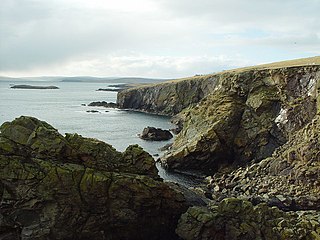
The Out Skerries are an archipelago of islets, some inhabited, in Shetland, Scotland, and are the easternmost part of Shetland. Locally, they are usually called Da Skerries or just Skerries.
Housay, also known as West Isle, is one of the three islands that form the Out Skerries island group, the most easterly part of the Shetland Isles.
Bruray is one of the three Out Skerries islands of Shetland, and contains Scotland's most easterly settlement.
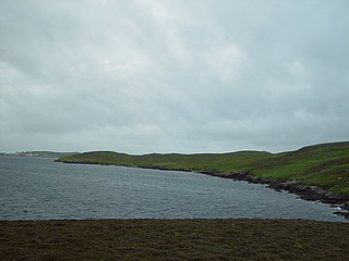
West Linga is an uninhabited island located between Mainland and Whalsay in Shetland, Scotland.
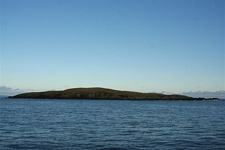
East Linga is one of the Shetland Islands. It lies between Whalsay, and Grif Skerry to the east.

Nesting is a parish in the Shetland Islands, Scotland. It includes a part of the east Shetland Mainland, measuring about twelve by four miles, along the seaboard from Gletness to Lunna Ness, and also the island of Whalsay and the Out Skerries. The coast is deeply indented by voes and headlands. The arable land comprises only about 1,000 acres, the remainder being mostly open moorland. The total area is given as 105.6 km2. This includes the ancient parish of Lunnasting in the North and the island parish of Whalsay to the east, which were added to Nesting in 1891. Before that, the ancient parishes of North Nesting and South Nesting were merged.

Tarner Island is a triangular shaped island in Loch Bracadale just off the coast off the Harlosh peninsula of Skye in Scotland. It is about 28 hectares in extent and is 0.65 miles at its longest by 0.33 miles at its widest
Shetland Islands Council Ferries is a company operating inter-island ferry services in Shetland, a subarctic archipelago off the northeast coast of Scotland.

Isbister Holm is a small islet in the Shetland islands of Scotland, situated roughly 2 kilometres (1.2 mi) east off the coast of Isbister, Whalsay. The highest point of the islet is about 65 feet (20 m) and it measures roughly 500 metres (1,600 ft) by 250 metres (820 ft). To the north are the islets of Mooa and Nista. On 12 November 1778 Jufron Ingester was shipwrecked, probably on the holm, the precise location not being certain. It was carrying some 260 tons of skins, tallow and coarse hose from Ireland to Copenhagen. One crew member died and the cargo was not salvaged.

Mooa is a small islet of the Shetland Islands of Scotland, situated roughly 2 kilometres (1.2 mi) east off the coast of Whalsay. It lies to the north of Isbister Holm and south of Nista. The highest point of the islet is 63 feet (19 m).

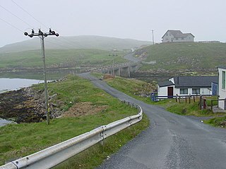
Brough is a settlement in western Whalsay in the parish of Nesting in the Shetland islands of Scotland. It lies to the southwest of Challister, northeast of New Park, and north of Tripwell. To the north is Kirk Ness, and Whalsay Parish Church.
The Inner Holm of Skaw is a small, uninhabited islet off the northern tip of the island of Whalsay, in the Shetland Islands of Scotland, north of the village of Skaw.
Whalsay Airstrip is located at the village of Skaw in the northern end of the island of Whalsay, Shetland, Scotland. It is the only airfield serving the island and is available for charter flights. The landing surface, which is 18 metres (59 ft) wide and 457 metres (1,499 ft) long, is constructed from rolled gravel.

The Skate of Marrister is a flat ledge that extends about 300 yards (270 m) from the western shore of Whalsay, in the Shetland islands of Scotland. It is slightly more than 1 mile (1.6 km) north-north-west from Symbister Ness off the village of Marrister, in Linga Sound. At low tide the ledge rises 5 feet (1.5 m) above the water. There is a risk that the strong tide in Whalsay Sound will carry a boat onto the Skate. There is a minor light on the Skate with a nominal range of four miles, flashing green every six seconds.
Rumble is a skerry in the Shetland islands of Scotland, situated roughly 4 kilometres (2.5 mi) east off the coast of Huxter, southeastern Whalsay. It lies 0.75 miles (1.21 km) to southwest of East Linga. The main island, also known as Rumble Holm, is 27 feet (8.2 m) high. Nearby and to the north are the Flaeshans of Rumble, a series of small islets and stacks and Burlastack of Rumble lies to the east. On the northern side of the main island is an inlet, known as the Voe of Rumble. Lobsters and prawns are said to shelter here. It is also mentioned that a ship named Griften of unknown nationality was shipwrecked either here or on the Holm of Sandwick in 1611.
The Holm of Sandwick is an islet, located roughly 100 metres (330 ft) off Haa Ness and the southwestern side of Whalsay, in the Shetland Islands of Scotland. The small groups of islets to the west are called the Flaeshans of Sandwick. To the southwest is Sava Skerry. It is reported that a ship named Griften of unknown nationality was shipwrecked either here or on Rumble Holm in 1611.
