
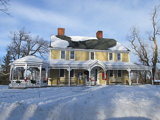
The Lunenburg Historic District is a historic district encompassing the historic center of Lunenburg, Massachusetts. The district is centered on a stretch of Main Street which connects two triangular intersections. It includes many of the town's oldest buildings, including the c. 1724 Cushing House, and the c. 1730 Stillman Stone House. Three of the town's most significant institutional buildings were built before 1850: the town hall, the Congregational church, and the Methodist church. The district was added to the National Register of Historic Places in 1988.

The Monument Square Historic District is a historic district on Main and Water Streets, and Grove Avenue in Leominster, Massachusetts. The district includes Leominster's traditional town common or square, which is known as "Leominster Square" or "the Common."

Farnumsville Historic District is a historic district encompassing a historic mill village in Grafton, Massachusetts. It is located on the eastern bank of the Blackstone River, extending along Providence and Main Streets, roughly between Cross and Depot Streets, and radiating along those roads and adjacent streets. This area was one of Grafton's 19th century industrial mill villages, which was centered on the Farnum Mill, which first began operating in the second decade of the 19th century. The main mill building that survives dates to 1844, and the housing stock in the village is in a diversity of styles, built roughly between the 1820s and 1920s.

The Princeton Center Historic District is a historic district encompassing the 19th century center of Princeton, Massachusetts. The district is centered at the junction of Hubbardston and Mountain Roads, and includes the town common, town hall, public library, and First Congregational Church. When first listed on the National Register of Historic Places in 1999, the district encompassed 11 acres (4.5 ha), and included only the common, town hall, and library; it was expanded in 2006 to 165 acres (67 ha), and included much of the village of Princeton Center.
The Russell Corner Historic District of Princeton, Massachusetts encompasses a small 19th century commercial center that developed into a summer resort area by the early 20th century. Centered at the intersection of Merriam Road and Gregory Hill Road, the district includes fifteen contributing buildings on 124 acres (50 ha), which are predominantly residential in nature, and were mostly built before 1830. Some of the properties are found on East Princeton and Sterling Roads, and Bullock Lane. The district was listed on the National Register of Historic Places in 2006.

The North Falmouth Village Historic District encompasses the historic 19th-century village of North Falmouth, Massachusetts, which is a village in the town of Falmouth, Massachusetts. It is a linear district, extending along Old Main Road south from its junction with Massachusetts Route 28A to Winslow Road. This area gradually developed over the 19th century, principally in support of maritime activities centered on Buzzards Bay to the west. The district contains a cross-section of architectural styles popular from the early 19th to early 20th centuries. It was listed on the National Register of Historic Places in 1998.

The South Egremont Village Historic District encompasses most of the village of South Egremont, Massachusetts, a well-preserved village whose architecture has seen relatively little alteration since the 1840s. It is located along Massachusetts Route 23 in the plains east of the Taconic Mountains. The district was listed on the National Register of Historic Places in 1984.

The Ashfield Plain Historic District is a historic district roughly, along Main and South Streets and adjacent parts of Buckland and Norton Hill Roads in Ashfield, Massachusetts. It encompasses the village center of the town, which has acted as a civic and commercial center since the late 18th century. Its architectural heritage dates back to that time, but is now dominated by buildings from the late 19th and early 20th centuries. The district was listed on the National Register of Historic Places in 1991.

The East Hawley Center Historic District encompasses the principal institutional center of the town of Hawley, Massachusetts, with a history dating to the 1780s. Although it was settled in the late 18th century, issues with Hawley's boundaries meant that the development of a central village did not take place until later. East Hawley was developing as a local transportation hub by the mid-1820s, with several roads converging in the area. The establishment of a store and post office, and the relocation of the Congregational Church into the area cemented its importance in the town's civic life. There was some industrial mill activity in the area during the 19th century, but this came to an end near the end of the century, and only a mill pond remains. The district was listed on the National Register of Historic Places in 1992.

The Montague Center Historic District encompasses the well-preserved 19th century village center of Montague, Massachusetts. Montague Center, one of the town's five villages, is the civic heart of the town, and was also an active industrial area in the 19th century. The district was listed on the National Register of Historic Places in 2001.

The Granville Village Historic District is a historic district encompassing the historic Granville Village area in eastern Granville, Massachusetts. The area was developed in the 19th century as an industrial village, centered on the drum factory of Noble & Cooley on Dickinson Brook. The predominantly residential district includes a number of Greek Revival houses; it also includes the Colonial Revival public library building. It is located roughly in the area around the junction of Maple St. and Main and Granby Rds., including part of Water Street. The district was listed on the National Register of Historic Places in 1991.

The West Granville Historic District is a historic district encompassing the center of West Granville, Massachusetts. The village is composed mainly of buildings form the late 18th and early 19th centuries, including an 18th-century church and 1830s academy building. The district was listed on the National Register of Historic Places in 1991.

The Shirley Village Historic District encompasses the main commercial and industrial village of Shirley, Massachusetts. It is located in the southern part of the town, and grew up around a series of mills that were located along Catacoonamug Brook, and then the railroad, which was built through the area in the 1840s. The district contains 441 properties. It is roughly bounded by Center, Harvard, Leominster and Shaker Roads. The district was listed on the National Register of Historic Places in 1992.

The Taftsville Historic District encompasses a historic 19th-century industrial village that is mostly in Woodstock, Vermont. Flanking the Ottauquechee River and extending up Happy Valley Road, the area developed around a metal tool factory established by members of the Taft family in 1793. Important elements from its early history include the Taftsville Store, built by the Taft family in 1840, and the Taftsville Covered Bridge, built in 1836. The district was listed on the National Register of Historic Places in 2001.

The Chesterfield Center Historic District is a historic district that encompasses the traditional village center of the town of Chesterfield, Massachusetts. The village is reflective of the town's 18th and 19th-century development as an agrarian hill community, with architectural styles before about 1850 predominating. The district was listed on the National Register of Historic Places in 2000.

The West Village Historic District of Princeton, Massachusetts, encompasses the historic heart of its West Village. The 465-acre (188 ha) district abuts the Princeton Center Historic District to the east, and was listed on the National Register of Historic Places in 2009.

The Head of the River Historic District is a historic district encompassing a village area at the head of navigation of the Acushnet River, which separates Acushnet and New Bedford, Massachusetts. The village is centered at the junction of Tarkin Hill Road, River Road, and Mill Road in New Bedford, and Main Street in Acushnet. The area went through two significant periods of development: the first was in the late 18th and early 19th century, and the second was in the early 20th century. The district was listed on the National Register of Historic Places in 2009.

The Jewell Town District of South Hampton, New Hampshire, encompasses a colonial-era industrial village with a history dating to 1687. It is centered at the junction of West Whitehall and Jewell Streets, which is just south of a bend in the Powwow River, the source of the power for the mills that were built here. The area was settled in 1687 by Thomas Jewell, and by the early 19th century included a variety of mills as well as a bog iron works. The district now includes only remnants of its industrial past, and features a collection of 18th and early-19th century residential architecture. The district was listed on the National Register of Historic Places in 1983.

The Town Center Historic District encompasses the historic village center of South Hampton, New Hampshire. Centered around the Barnard Green, the town common, on New Hampshire Route 107A, it includes architectural reminders of the town's growth and change over time. The district was listed on the National Register of Historic Places in 1983.
The Four Corners–Goodnow Farm Historic District of Princeton, Massachusetts encompasses a rural agricultural area with well-preserved buildings dating from the 18th to 20th centuries. It is located in the western part of the town, and is centered on the junction of Old Colony, Gates, and Thompson Roads. The district was listed on the National Register of Historic Places in 2015.


