
Capitol Hill is a densely populated residential district in Seattle, Washington, United States. One of the city's most popular nightlife and entertainment districts, it is home to a historic gay village and vibrant counterculture community.

The Ward House is a house on Capitol Hill in Seattle, Washington, USA. Having been built in 1882, it is one of the oldest houses in Seattle. Existing houses reportedly built before 1882 in Seattle include the 2629 East Aloha Street (1881), 727 28th Avenue (1870) and Maynard's House located at 3045 64th Avenue Southwest.

Queen Anne is a neighborhood and geographic feature in Seattle, Washington, United States, located northwest of downtown. Queen Anne covers an area of 7.3 square kilometers (2.8 sq mi), and has a population of about 28,000. It is bordered by Belltown to the south, Lake Union to the east, the Lake Washington Ship Canal to the north and Interbay to the west.

First Hill is a neighborhood in Seattle, Washington, United States. It is named for the hill on which it is located, which in turn is so named for being the first hill encountered while traveling east from downtown Seattle toward Lake Washington. First Hill is bounded on the west by Interstate 5, beyond which is Downtown, on the north by E. Pike and E. Madison Streets, beyond which is Capitol Hill, and on the south by Yesler Way, beyond which is the International District. The City of Seattle provides conflicting information about its eastern limit, beyond which are Cherry Hill and the Central District. Some describe it as being bounded by Broadway and Boren Avenues, while others describe it as being bounded by 12th Avenue.
Cascade is an urban neighborhood abutting Downtown Seattle, Washington, United States, located adjacent to South Lake Union. It is bounded by: Fairview Avenue North on the west, beyond which is the rest of the Cascade Neighborhood; the Interstate 5 interchange for Mercer St to the north, beyond which is Eastlake; Interstate 5 on the east, beyond which is Capitol Hill; and Denny Way on the south, beyond which is Denny Triangle. It is surrounded by thoroughfares Mercer Street (eastbound), Fairview Avenue N. and Eastlake Avenue E., and Denny Way. The neighborhood, one of Seattle's oldest, originally extended much further: west to Terry Avenue, south to Denny Hill on the South, and east to Melrose Avenue E through the area now obliterated by Interstate 5. Some recent writers consider Cascade to omit the northern "arm", while others extend it westward to cover most of South Lake Union.
The Central Area, commonly called the Central District or The CD, is a mostly residential district in Seattle located east of downtown and First Hill ; west of Madrona, Leschi and Mt. Baker; south of Capitol Hill, and north of Rainier Valley. Historically, the Central District has been one of Seattle's most racially and ethnically diverse neighborhoods, and was once the center of Seattle's black community and a major hub of African-American businesses.
South Lake Union is a neighborhood in Seattle, Washington, so named because it is at the southern tip of Lake Union.

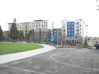
Yesler Terrace is a 22-acre (8.9 ha) public housing development in Seattle, Washington, United States. It was completed in 1941 as the state's first public housing development and the first racially integrated public housing development in the United States. It occupies much of the area formerly known as Yesler Hill, Yesler's Hill, or Profanity Hill. The development is administered by the Seattle Housing Authority, who have been redeveloping the neighborhood into a mixed-income area with multi-story buildings and community amenities since 2013.

Frederick William Anhalt was a builder and contractor who constructed many distinguished rental apartment buildings in Seattle, Washington in the 1920s and early 1930s. In 1993, the Seattle Chapter of the American Institute of Architects (AIA) awarded Anhalt an honorary membership in recognition of excellence in residential design. In 2001, The Seattle Times listed Anhalt as one of the 150 most influential people in Seattle History His buildings have been referred to as "Castles in Seattle."

Cherry Hill is a predominantly residential area in Seattle, Washington located south of Capitol Hill within the Central District, north of the International District, and east of First Hill. Cherry Hill is bound on the west by 14th Avenue, on the east by 23rd Avenue, on the north by East Madison Street and on the south by East Yesler Way. Cherry Hill overlaps considerably with the neighborhood of Squire Park as defined by the Squire Park Neighborhood Council. In the Seattle City Clerk's Geographic Indexing Atlas, Cherry Hill is designated as the Minor neighborhood of the Central Area. Cherry Hill was previously called Second Hill or Renton Hill.

Capitol Hill station is a light rail station in the Capitol Hill neighborhood of Seattle, Washington, United States. The station is served by Sound Transit's Link light rail system and is located near the intersection of Broadway and East John Street. It is situated between the Westlake and University of Washington stations on the 1 Line. The station consists of an island platform approximately 65 feet (20 m) under street level, connected to three surface entrances via two mezzanines. It contains pieces of public art, including Mike Ross's sculpture Jet Kiss and two murals by cartoonist Ellen Forney.

The First Hill Streetcar, officially the First Hill Line, is a streetcar route in Seattle, Washington, United States, forming part of the modern Seattle Streetcar system. It travels 2.5 miles (4.0 km) between several neighborhoods in central Seattle, including the International District, First Hill, and Capitol Hill. The line has ten stops and runs primarily in mixed traffic on South Jackson Street and Broadway.

Broadway is a major north–south thoroughfare in Seattle, Washington. The 1.6-mile-long (2.6 km) arterial runs north from Yesler Way at Yesler Terrace through the First Hill and Capitol Hill neighborhoods to East Roy Street. Broadway East continues north to East Highland Drive. North of there the street is made up of shorter segments: one from just south of East Blaine Street to just north of East Miller Street, another from East Roanoke Street to East Shelby Street, and the last from East Allison Street to Fuhrman Avenue East.

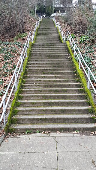
The Howe Street Stairs are a public, outdoor staircase that straddles Seattle's Capitol Hill and Eastlake neighborhoods. They were constructed in 1911.

The Capitol Hill Branch is a branch of the Seattle Public Library in the Capitol Hill, Seattle neighborhood of Seattle, Washington, US. The original library, located at Harvard Avenue and Republican Street, opened in 1954 and was named the Susan J. Henry Branch at the request of its benefactor. The Henry Branch was demolished in 2001 and the modern Capitol Hill Branch was opened at the same location in 2003.
Denny Way is an east–west arterial street in downtown Seattle, Washington, United States. It forms the northern end of the Belltown street grid as well as the boundaries of Belltown, Lower Queen Anne, South Lake Union, Denny Triangle, and Cascade. The street continues east through Capitol Hill to Madrona as a minor neighborhood street, ending near Madrona Park on Lake Washington.

Pine Street is a major east–west street in Seattle, Washington, United States. It travels parallel to Pike Street between Downtown Seattle and the retail core to Capitol Hill, the Central District, and Madrona.
The Blaine Street Stairs are an outdoor staircase in Seattle's Capitol Hill neighborhood, in the United States. Adjacent to the Streissguth Gardens and parallel to the Howe Street Stairs, the staircase has 293 steps.
