
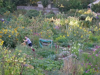
Capitol Hill is a densely populated residential district in Seattle, Washington, United States. One of the city's most popular nightlife and entertainment districts, it is home to a historic gay village and vibrant counterculture community.

State Route 99 (SR 99), also known as the Pacific Highway, is a state highway in the Seattle metropolitan area, part of the U.S. state of Washington. It runs 49 miles (79 km) from Fife to Everett, passing through the cities of Federal Way, SeaTac, Seattle, Shoreline, and Lynnwood. The route primarily follows arterial streets, including Aurora Avenue, and has several freeway segments, including the tolled SR 99 Tunnel in Downtown Seattle. SR 99 was officially named the William P. Stewart Memorial Highway by the state legislature in 2016, after a campaign to replace an unofficial moniker honoring Confederate president Jefferson Davis.

The Seattle Center Monorail is an elevated straddle-beam monorail line in Seattle, Washington, United States. The 0.9-mile (1.4 km) monorail runs along 5th Avenue between Seattle Center and Westlake Center in Downtown Seattle, making no intermediate stops. The monorail is a major tourist attraction but also operates as a regular public transit service with trains every ten minutes running for up to 16 hours per day. It was constructed in eight months at a cost of $4.2 million for the 1962 Century 21 Exposition, a world's fair hosted at Seattle Center. The monorail underwent major renovations in 1988 after the southern terminal was moved from its location over Pine Street to inside the Westlake Center shopping mall.
The Alaskan Way Viaduct was an elevated freeway in Seattle, Washington, United States, that carried a section of State Route 99. The double-decked freeway ran north–south along the city's waterfront for 2.2 miles (3.5 km), east of Alaskan Way and Elliott Bay, and traveled between the West Seattle Freeway in SoDo and the Battery Street Tunnel in Belltown.
Wedgwood is a middle class residential neighborhood of northeast Seattle, Washington with a modest commercial strip. Wedgwood is located about two miles (3.2 km) north, and slightly east, of the University of Washington; it is about six miles (9.7 km) northeast of Downtown. The neighborhood is further typical of Seattle neighborhoods in having more than one name and having different, overlapping, but well-documented definitions of the neighborhood.

View Ridge is a neighborhood in north Seattle, Washington. As with all Seattle neighborhoods, its boundaries are not fixed, but can be thought of as NE 65th Street in the south, 40th and 45th Avenues NE in the west, the Sand Point Country Club in the north, and Sand Point Way NE in the east. Many homes offer views of Lake Washington, Mount Rainier, and the Cascade Range. View Ridge Elementary School is located within the neighborhood, and the neighborhood also offers a large park and playfield across the street from the elementary school. The View Ridge Swim and Tennis Club is located on the eastern edge of View Ridge, and the Sand Point Country Club is located on the northern edge.

The Seattle Convention Center (SCC), formerly the Washington State Convention Center (WSCC), is a convention center in Seattle, Washington, United States. It consists of two buildings in Downtown Seattle with exhibition halls and meeting rooms: Arch along Pike Street and Summit on the north side of Pine Street. The former straddles Interstate 5 and connects with Freeway Park. The convention center was planned in the late 1970s and funded through $90 million in bonds issued by the state legislature.

Interstate 90 (I-90), designated as the American Veterans Memorial Highway, is a transcontinental Interstate Highway that runs from Seattle, Washington, to Boston, Massachusetts. It crosses Washington state from west to east, traveling 298 miles (480 km) from Seattle across the Cascade Mountains and into Eastern Washington, reaching the Idaho state line east of Spokane. I-90 intersects several of the state's other major highways, including I-5 in Seattle, I-82 and U.S. Route 97 (US 97) near Ellensburg, and US 395 and US 2 in Spokane.

Interstate 5 (I-5) is an Interstate Highway on the West Coast of the United States that serves as the region's primary north–south route. It spans 277 miles (446 km) across the state of Washington, from the Oregon state border at Vancouver, through the Puget Sound region, to the Canadian border at Blaine. Within the Seattle metropolitan area, the freeway connects the cities of Tacoma, Seattle, and Everett.

Pike Place Market is a public market in Seattle, Washington, United States. It opened on August 17, 1907, and is one of the oldest continuously operated public farmers' markets in the United States. Overlooking the Elliott Bay waterfront on Puget Sound, it serves as a place of business for many small farmers, craftspeople and merchants. It is named for its central street, Pike Place, which runs northwest from Pike Street to Virginia Street on the western edge of Downtown Seattle. Pike Place Market is Seattle's most popular tourist destination and the 33rd most visited tourist attraction in the world, with more than 10 million annual visitors.
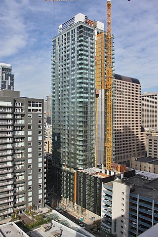
2nd & Pike, also known as the West Edge Tower, is a 440-foot-tall (130 m) residential skyscraper in Seattle, Washington. The 39-story tower, developed by Urban Visions and designed by Tom Kundig of Olson Kundig Architects, has 339 luxury apartments and several ground-level retail spaces. The 8th floor includes a Medical One primary care clinic.
Plymouth Congregational Church is a historic congregation located in downtown Seattle and associated with the United Church of Christ denomination. Plymouth is known for its history of social justice advocacy, music and its creation of programs to serve the homeless, such as Plymouth Healing Communities and Plymouth Housing. The Rev. Dr. Kelle Brown is the Senior Pastor. She leads collaboratively with associate pastor Rev. Kevin Bechtold.
Pike Street is an east-west street in Seattle. It extends from Pike Place above Seattle's saltwater waterfront at Elliott Bay through Downtown Seattle, across Capitol Hill to the freshwater shore of Lake Washington at Lake Washington Boulevard. A segment less than a block long exists at Alaskan Way on Elliott Bay, connected to the rest of the street only by the pedestrian Pike Street Hill Climb; the bottom of the hillclimb under the Alaskan Way Viaduct was the original shoreline of the city before major modification and construction of the Seattle Seawall. It is included in the south-to-north mnemonic "Jesus Christ Made Seattle Under Protest" for the street layout of Seattle.
Denny Way is an east–west arterial street in downtown Seattle, Washington, United States. It forms the northern end of the Belltown street grid as well as the boundaries of Belltown, Lower Queen Anne, South Lake Union, Denny Triangle, and Cascade. The street continues east through Capitol Hill to Madrona as a minor neighborhood street, ending near Madrona Park on Lake Washington.
Germantown Pike is a historic road in Pennsylvania that opened in 1687, running from Philadelphia northwest to Collegeville. The road is particularly notable for the "imposing mansions" that existed in the Germantown neighborhood in Philadelphia. The road was left in ruins after the British destroyed it in the Revolutionary War during the 1777 Battle of Germantown, and was not rebuilt until 1809. Portions of Germantown Pike were signed as U.S. Route 422 (US 422) before the latter was rerouted along a freeway alignment to King of Prussia.

The North Transfer Station, also known as the North Recycling and Disposal Station, is a municipal waste collection and distribution facility in Seattle, Washington, United States. It is located in the Wallingford neighborhood near Gas Works Park and is one of two transfer stations managed by Seattle Public Utilities.

Pine Street is a major east–west street in Seattle, Washington, United States. It travels parallel to Pike Street between Downtown Seattle and the retail core to Capitol Hill, the Central District, and Madrona.
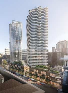
WB1200, also known as 1200 Stewart, is a future twin skyscraper complex in the Denny Triangle neighborhood of Seattle, Washington, United States. The project is located at the intersection of Stewart Street and Denny Way and comprises 1,014 apartments and retail space in two 48-story buildings. The retail space, housed in a three-story podium with an indoor galleria, is planned to feature a music venue and a Boeing 747-400 fuselage. It began construction in 2018 and is scheduled to be completed in early 2024.

The Red Popsicle is a 2011 sculpture by Catherine Mayer, installed in Seattle's Belltown neighborhood, in the U.S. state of Washington.

