East Rocky Hill, New Jersey

Last updated

East Rocky Hill, New Jersey
Location map of Somerset County, New Jersey.svg
Red pog.svg
East Rocky Hill
Location in Somerset County
USA New Jersey relief location map.svg
Red pog.svg
East Rocky Hill
Location in New Jersey
Usa edcp relief location map.png
Red pog.svg
East Rocky Hill
Location in the United States
Coordinates: 40°24′54″N74°37′04″W / 40.415133°N 74.617903°W / 40.415133; -74.617903 [1] [2]
Country Flag of the United States.svg  United States
State Flag of New Jersey.svg  New Jersey
County Somerset
Township Franklin
Area
[3]
  Total4.25 sq mi (11.01 km2)
  Land4.17 sq mi (10.79 km2)
  Water0.08 sq mi (0.21 km2)  2.05%
Elevation
[4]
289 ft (88 m)
Population
 (2020) [5]
  Total468
  Density112.31/sq mi (43.37/km2)
Time zone UTC−05:00 (Eastern (EST))
  Summer (DST) UTC−04:00 (Eastern (EDT))
Area code(s) 609 and 732/848
FIPS code 34-19490 [1] [6]
GNIS feature ID02583986 [1]

East Rocky Hill is an unincorporated community and census-designated place (CDP) [7] located in Franklin Township, in Somerset County, in the U.S. state of New Jersey. [8] [9] [10] As of the 2010 United States Census, the CDP's population was 469. [11]

Contents

Geography

According to the United States Census Bureau, East Rocky Hill had a total area of 4.252 square miles (11.014 km2), including 4.165 square miles (10.788 km2) of land and 0.087 square miles (0.226 km2) of water (2.05%). [1] [2]

Demographics

Historical population
CensusPop.Note
2010 469
2020 468−0.2%
Population sources:
2010 [11] 2020 [5]

2010 census

The 2010 United States census counted 469 people, 160 households, and 115 families in the CDP. The population density was 112.6 per square mile (43.5/km2). There were 172 housing units at an average density of 41.3 per square mile (15.9/km2). The racial makeup was 74.20% (348) White, 7.68% (36) Black or African American, 0.00% (0) Native American, 7.04% (33) Asian, 0.00% (0) Pacific Islander, 8.96% (42) from other races, and 2.13% (10) from two or more races. Hispanic or Latino of any race were 15.57% (73) of the population. [11]

Of the 160 households, 30.0% had children under the age of 18; 64.4% were married couples living together; 4.4% had a female householder with no husband present and 28.1% were non-families. Of all households, 22.5% were made up of individuals and 8.8% had someone living alone who was 65 years of age or older. The average household size was 2.93 and the average family size was 3.39. [11]

26.4% of the population were under the age of 18, 7.2% from 18 to 24, 22.2% from 25 to 44, 29.6% from 45 to 64, and 14.5% who were 65 years of age or older. The median age was 40.6 years. For every 100 females, the population had 110.3 males. For every 100 females ages 18 and older there were 100.6 males. [11]

Related Research Articles

<span class="mw-page-title-main">Ashland, New Jersey</span> Populated place in Camden County, New Jersey, US

Ashland is an unincorporated community and census-designated place (CDP) located within Cherry Hill, in Camden County, in the U.S. state of New Jersey. As of the 2010 United States Census, the CDP's population was 8,302.

<span class="mw-page-title-main">Cherry Hill Mall, New Jersey</span> Populated place in Camden County, New Jersey, US

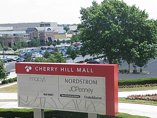
Cherry Hill Mall is an unincorporated community and census-designated place (CDP) located in Cherry Hill, in Camden County, in the U.S. state of New Jersey. As of the 2020 United States census, the CDP’s population was 14,805, its highest decennial count ever and an increase of 634 (+4.5%) from the 14,171 residents recorded at the 2010 census count, which in turn reflected an increase of 933 (+7.0%) from the 13,238 counted in the 2000 census. The CDP is home to the namesake Cherry Hill Mall shopping complex.

<span class="mw-page-title-main">Golden Triangle, New Jersey</span> Populated place in Camden County, New Jersey, US

Golden Triangle is an unincorporated community and census-designated place (CDP) located within Cherry Hill, in Camden County, in the U.S. state of New Jersey. As of the 2010 United States Census, the CDP's population was 4,145.

<span class="mw-page-title-main">Greentree, New Jersey</span> Populated place in Camden County, New Jersey, US

Greentree is an unincorporated community and census-designated place (CDP) located within Cherry Hill Township, in Camden County, in the U.S. state of New Jersey. As of the 2010 United States Census, the CDP's population was 11,367.

<span class="mw-page-title-main">Springdale, New Jersey</span> Populated place in Camden County, New Jersey, US

Springdale is an unincorporated community and census-designated place (CDP) located within Cherry Hill Township, in Camden County, in the U.S. state of New Jersey. As of the 2010 United States Census, the section population was 14,518.

<span class="mw-page-title-main">Twin Rivers, New Jersey</span> Populated place in Mercer County, New Jersey, US

Twin Rivers is an unincorporated community and census-designated place (CDP) situated within East Windsor Township, in Mercer County, in the U.S. state of New Jersey. As of the 2020 United States census, Twin Rivers' population was 7,787 its highest decennial count ever and an increase of 344 (+4.6%) from the 7,443 recorded at the 2010 census, which in turn reflected an increase of 21 (+0.3%) from the 7,422 counted in the 2000 census. Twin Rivers was the first planned unit development in New Jersey.

<span class="mw-page-title-main">Society Hill, Middlesex County, New Jersey</span> Populated place in Middlesex County, New Jersey, US

Society Hill is an unincorporated community and census-designated place (CDP) located within Piscataway Township, in Middlesex County, in the U.S. state of New Jersey. As of the 2010 United States Census, the CDP's population was 3,829.

<span class="mw-page-title-main">East Freehold, New Jersey</span> Populated place in Monmouth County, New Jersey, US

East Freehold is an unincorporated community and census-designated place (CDP) located within Freehold Township, in Monmouth County, in the U.S. state of New Jersey. As of the 2010 United States Census, the CDP's population was 4,894.

<span class="mw-page-title-main">Fairview, Monmouth County, New Jersey</span> Populated place in Monmouth County, New Jersey, US

Fairview is an unincorporated community and census-designated place (CDP) located within Middletown Township, in Monmouth County, in the U.S. state of New Jersey. As of the 2010 United States Census, the CDP's population was 3,806.

<span class="mw-page-title-main">North Middletown, New Jersey</span> Populated place in Monmouth County, New Jersey, US

North Middletown is an unincorporated community and census-designated place (CDP) within Middletown Township, in Monmouth County, in the U.S. state of New Jersey. As of the 2010 United States Census, the CDP's population was 3,295.

<span class="mw-page-title-main">Shark River Hills, New Jersey</span> Populated place in Monmouth County, New Jersey, US

Shark River Hills is an unincorporated community and census-designated place (CDP) within Neptune Township, in Monmouth County, in the U.S. state of New Jersey. As of the 2010 United States Census, the CDP's population was 3,697.

<span class="mw-page-title-main">Allenwood, New Jersey</span> Populated place in Monmouth County, New Jersey, US

Allenwood is an unincorporated community and census-designated place (CDP) located within Wall Township, in Monmouth County, in the U.S. state of New Jersey. As of the 2010 United States Census, the CDP's population was 925.

<span class="mw-page-title-main">Cedar Glen Lakes, New Jersey</span> Populated place in Ocean County, New Jersey, US

Cedar Glen Lakes is an unincorporated community and census-designated place (CDP) located within Manchester Township, in Ocean County, in the U.S. state of New Jersey. As of the 2010 United States Census, the CDP's population was 1,421.

<span class="mw-page-title-main">Leisure Village, New Jersey</span> Populated place in Ocean County, New Jersey, US

Leisure Village is an unincorporated community and census-designated place (CDP) located within Lakewood Township, in Ocean County, in the U.S. state of New Jersey. As of the 2010 United States Census, the CDP's population was 4,400. The sprawling active adult community is also locally known as "Original" Leisure Village because it was the first of three neighboring active adult communities bearing similar names. Leisure Village East, and Leisure Village West are the other two communities nearby. Original Leisure Village (OLV) is also referred to by the moniker "The Village of Seven Lakes."

<span class="mw-page-title-main">Leisure Village East, New Jersey</span> Populated place in Ocean County, New Jersey, US

Leisure Village East is an unincorporated community and census-designated place (CDP) located within Lakewood Township, in Ocean County, in the U.S. state of New Jersey. As of the 2010 United States Census, the CDP's population was 4,217. Leisure Village East is one of several active adult communities bearing similar names. Leisure Village and Leisure Village West are the other two communities nearby.

<span class="mw-page-title-main">Leisure Village West, New Jersey</span> Populated place in Ocean County, New Jersey, US

Leisure Village West is an unincorporated community and census-designated place (CDP) located within Manchester Township, in Ocean County, in the U.S. state of New Jersey. Until the 2000 census, the CDP had been part of the Leisure Village West-Pine Lake Park CDP, which was split for the 2010 enumeration into separate CDPs for Leisure Village West and Pine Lake Park. As of the 2010 United States Census, the CDP's population was 3,493. Leisure Village West is one of several active adult communities bearing similar names. Leisure Village and Leisure Village East are the other two communities nearby.

<span class="mw-page-title-main">Ellisburg, New Jersey</span> Populated place in Camden County, New Jersey, US

Ellisburg is an unincorporated community and census-designated place (CDP) located within Cherry Hill Township, in Camden County, in the U.S. state of New Jersey. As of the 2010 United States Census, the CDP's population was 8,168. The area had been part of the combined Erlton-Ellisburg CDP, which was discontinued after the 2000 census.

East Franklin is an unincorporated community and census-designated place (CDP) located in Franklin Township, in Somerset County, in the U.S. state of New Jersey. At the 2010 United States Census, East Franklin's population was 8,669.

<span class="mw-page-title-main">Kingston Estates, New Jersey</span> Populated place in Camden County, New Jersey, US

Kingston Estates is an unincorporated community and census-designated place (CDP) located within Cherry Hill, in Camden County, in the U.S. state of New Jersey, that had been part of the Barclay-Kingston CDP until the 2000 census, which was split to form the CDPs of Barclay and Kingston Estates as of the 2010 Census. As of the 2010 United States Census, the CDP's population was 5,685.

<span class="mw-page-title-main">Ten Mile Run, New Jersey</span> Populated place in Somerset County, New Jersey, US

Ten Mile Run is an unincorporated community and census-designated place (CDP) located in Franklin Township, in Somerset County, in the U.S. state of New Jersey. As of the 2010 United States Census, the CDP's population was 1,959.

References

  1. 1 2 3 4 Gazetteer of New Jersey Places, United States Census Bureau. Accessed July 21, 2016.
  2. 1 2 US Gazetteer files: 2010, 2000, and 1990, United States Census Bureau. Accessed September 4, 2014.
  3. "ArcGIS REST Services Directory". United States Census Bureau. Retrieved October 11, 2022.
  4. U.S. Geological Survey Geographic Names Information System: East Rocky Hill Census Designated Place, Geographic Names Information System. Accessed August 23, 2012.
  5. 1 2 Census Data Explorer: East Rocky Hill CDP, New Jersey, United States Census Bureau. Accessed June 15, 2023.
  6. Geographic Codes Lookup for New Jersey, Missouri Census Data Center. Accessed June 9, 2023.
  7. State of New Jersey Census Designated Places - BVP20 - Data as of January 1, 2020, United States Census Bureau. Accessed December 1, 2022.
  8. GCT-PH1 - Population, Housing Units, Area, and Density: 2010 - County -- County Subdivision and Place from the 2010 Census Summary File 1 for Somerset County, New Jersey Archived 2020-02-12 at archive.today , United States Census Bureau. Accessed February 11, 2013.
  9. 2006-2010 American Community Survey Geography for New Jersey, United States Census Bureau. Accessed February 11, 2013.
  10. New Jersey: 2010 - Population and Housing Unit Counts - 2010 Census of Population and Housing (CPH-2-32), United States Census Bureau, August 2012. Accessed February 11, 2013.
  11. 1 2 3 4 5 DP-1 - Profile of General Population and Housing Characteristics: 2010 Demographic Profile Data for East Rocky Hill CDP, New Jersey Archived February 12, 2020, at archive.today , United States Census Bureau. Accessed August 23, 2012.