Griggstown, New Jersey

Last updated

Griggstown, New Jersey
Griggstown Reformed Church, Griggstown, NJ.jpg
Griggstown Reformed Church
Location map of Somerset County, New Jersey.svg
Red pog.svg
Griggstown
Location in Somerset County
USA New Jersey relief location map.svg
Red pog.svg
Griggstown
Location in New Jersey
Usa edcp relief location map.png
Red pog.svg
Griggstown
Location in the United States
Coordinates: 40°26′24″N74°35′54″W / 40.439868°N 74.598319°W / 40.439868; -74.598319 [1] [2]
Country Flag of the United States.svg  United States
State Flag of New Jersey.svg  New Jersey
County Somerset
Township Franklin
Named for Griggs family
Area
[3]
  Total2.52 sq mi (6.52 km2)
  Land2.44 sq mi (6.33 km2)
  Water0.07 sq mi (0.18 km2)  2.86%
Elevation
[4]
102 ft (31 m)
Population
 (2020) [5]
  Total835
  Density341.51/sq mi (131.83/km2)
Time zone UTC−05:00 (Eastern (EST))
  Summer (DST) UTC−04:00 (Eastern (EDT))
Area code(s) 609/640, 732/848 and 908
FIPS code 34-28470 [1] [6]
GNIS feature ID2583995 [4]

Griggstown is an unincorporated community and census-designated place (CDP) [7] located within Franklin Township, in Somerset County, in the U.S. state of New Jersey. [8] [9] [10] [11] As of the 2010 United States Census, the CDP's population was 819. [12] The area was first settled around 1733. The Millstone River and the Delaware and Raritan Canal both flow through Griggstown.

Contents

History

Many of the earliest European settlers of the area came from Gravesend, Brooklyn. Among these settlers were four sons born to John and Elizabeth Griggs: Benjamin (b. 1690), Daniel, Samuel, and Thomas. Griggstown was named after Benjamin Griggs, who established a grist mill on the Millstone River that served as a meeting place for the European farmers of the area and as such the center of the community that would become Griggstown.

From the 1970s to the early 2000s, Griggstown residents reported seeing a feral cow along the parallel Delaware and Raritan Canal and the Millstone River, [13] said to be a ghost of one that was one of many herded along the canal. An actual cow believed to be the feral cow was found in a ditch in November 23, 2002, dying after being rescued. [14]

Geography

According to the United States Census Bureau, the CDP had a total area of 2.519 square miles (6.524 km2), including 2.447 square miles (6.338 km2) of land and 0.072 square miles (0.187 km2) of water (2.86%). [1] [2]

Griggstown is adjacent to the communities of Kingston, Rocky Hill, Montgomery Township, Kendall Park (in South Brunswick), and Franklin Park. The closest city of note is Princeton, New Jersey.

Griggstown is accessible via Route 27 (Lincoln Highway), County Route 518 and U.S. Route 206. The major roads in Griggstown are Bunker Hill Road and Canal Road. There is also a small access road with a one-lane bridge(at one time referred to as "twin bridges") known as the Griggstown Causeway that offers access to and from Griggstown as well. The D&R Canal State Park is located on this road in conjunction with the canal side tow-path. [15]

Selected sites

Demographics

Historical population
CensusPop.Note
2010 819
2020 8352.0%
Population sources:
2010 [12] 2020 [5]

2010 census

The 2010 United States census counted 819 people, 346 households, and 230 families in the CDP. The population density was 334.7 per square mile (129.2/km2). There were 364 housing units at an average density of 148.8 per square mile (57.5/km2). The racial makeup was 86.81% (711) White, 2.81% (23) Black or African American, 0.24% (2) Native American, 4.03% (33) Asian, 0.00% (0) Pacific Islander, 2.56% (21) from other races, and 3.54% (29) from two or more races. Hispanic or Latino of any race were 6.23% (51) of the population. [12]

Of the 346 households, 25.7% had children under the age of 18; 57.2% were married couples living together; 6.6% had a female householder with no husband present and 33.5% were non-families. Of all households, 27.2% were made up of individuals and 11.6% had someone living alone who was 65 years of age or older. The average household size was 2.36 and the average family size was 2.92. [12]

18.1% of the population were under the age of 18, 4.6% from 18 to 24, 27.5% from 25 to 44, 32.4% from 45 to 64, and 17.5% who were 65 years of age or older. The median age was 44.9 years. For every 100 females, the population had 101.7 males. For every 100 females ages 18 and older there were 101.5 males. [12]

Historic district

Griggstown Historic District
Bridge Tender's House and Bridge, Griggstown, NJ.jpg
Bridge Tender's House and bridge over the Delaware and Raritan Canal
LocationRoughly Canal Road from Old Georgetown Road to Ten Mile Run
Area861 acres (348 ha)
NRHP reference No. 84002798 [16]
NJRHP No.2496 [17]
Significant dates
Added to NRHPAugust 2, 1984
Designated NJRHPJune 21, 1984

The Griggstown Historic District is a 861-acre (348 ha) national historic district encompassing the community along Canal Road from Old Georgetown Road to Ten Mile Run. It was added to the National Register of Historic Places on August 2, 1984 for its significance in agriculture, architecture, commerce, industry, and transportation. The district includes 68 contributing buildings. The Griggstown Reformed Church was established in 1842 as the First Reformed Protestant Dutch Church of Griggstown. The building was dedicated on August 8, 1843, and features Greek Revival architecture. The Bridge Tender's House, the Bridge Tender’s Station and the Lock Tender's House, all built for the Delaware and Raritan Canal, are contributing buildings. [18]

Notable people

People who were born in, residents of, or otherwise closely associated with Griggstown include:

See also

Related Research Articles

<span class="mw-page-title-main">Kingston, New Jersey</span> Populated place in Middlesex and Somerset counties, New Jersey, US

Kingston is an unincorporated community and census designated place (CDP) along the border of South Brunswick Township in Middlesex County and Franklin Township in Somerset County, and also located relatively near Princeton in Mercer County in the U.S. state of New Jersey. The historic settlement is in the Raritan Valley region, located along the course of the Millstone River. As of the 2010 United States Census, the CDP's population was 1,493, of which 1,222 were in South Brunswick Township and 271 in Franklin Township.

<span class="mw-page-title-main">Plainsboro Center, New Jersey</span> Populated place in Middlesex County, New Jersey, US

Plainsboro Center is an unincorporated community and census-designated place (CDP) located within Plainsboro Township, situated in southern Middlesex County, within the U.S. state of New Jersey. As of the 2020 United States census, the CDP's population was 2,760, its highest decennial count ever and an increase of 48 (+1.8%) from the 2,712 recorded at the 2010 census, which in turn reflected an increase of 503 (+22.8%) from the 2,209 counted in the 2000 census.

<span class="mw-page-title-main">West Freehold, New Jersey</span> Census-designated place in New Jersey, United States

West Freehold is an unincorporated community and census-designated place (CDP) within Freehold Township, in Monmouth County, New Jersey, United States. As of the 2010 United States Census, the CDP's population was 13,613. Due to the community's close proximity to the Battle of Monmouth, West Freehold is home to several important historical structures, which have been preserved in the 'West Freehold Village Historic District'. The historically preserved Monmouth Battlefield, along with the historic villages of Clarksburg, Englishtown, Smithburg and Tennent are a short distance away.

<span class="mw-page-title-main">Franklin Township, Somerset County, New Jersey</span> Township in Somerset County, New Jersey, United States

Franklin Township is a township in Somerset County, in the U.S. state of New Jersey. It is centrally located in the Raritan Valley region, within the New York Metropolitan Area. As of the 2020 United States census, the township's population was 68,364, an increase of 6,064 (+9.7%) from the 2010 census count of 62,300, which in turn reflected an increase of 11,397 (+22.4%) from the 50,903 counted in the 2000 census. The township was the state's 19th most-populous municipality in 2020, after being ranked 22nd in 2010.

<span class="mw-page-title-main">Millstone, New Jersey</span> Borough in Somerset County, New Jersey, United States

Millstone is a borough in Somerset County, in the U.S. state of New Jersey. The borough was originally known as Somerset Courthouse and was the county seat. As of the 2020 United States census, the borough's population was 448, an increase of 30 (+7.2%) from the 2010 census count of 418, which in turn reflected an increase of 8 (+2.0%) from the 410 counted in the 2000 census.

<span class="mw-page-title-main">Delaware and Raritan Canal</span> United States historic place

The Delaware and Raritan Canal is a canal in central New Jersey, built in the 1830s, that connects the Delaware River to the Raritan River. It was an efficient and reliable means of transportation of freight between Philadelphia and New York City, transporting anthracite coal from eastern Pennsylvania during much of the 19th and early 20th centuries. The canal allowed shippers to cut many miles off the existing route from the Pennsylvania Coal Region down the Delaware, around Cape May, and up the occasionally treacherous Atlantic Ocean coast to New York City.

<span class="mw-page-title-main">Blackwells Mills, New Jersey</span> Populated place in Somerset County, New Jersey, US

Blackwells Mills is an unincorporated community and census-designated place (CDP) located in Franklin Township in Somerset County, in the U.S. state of New Jersey. As of the 2010 U.S. census, the CDP's population was 803.

<span class="mw-page-title-main">Titusville, New Jersey</span> Populated place in Mercer County, New Jersey, US

Titusville is an unincorporated community and census-designated place (CDP) located within Hopewell Township in Mercer County, in the U.S. state of New Jersey. The area includes a post office with its own ZIP Code (08560), several restaurants, gas stations, a firehouse, and a small cluster of homes. The Washington Crossing State Park, dedicated to George Washington's crossing of the Delaware River in 1776, is adjacent to the community.

<span class="mw-page-title-main">Millstone River</span> Tributary of the Raritan River in New Jersey, United States

The Millstone River is a 38.6-mile-long (62.1 km) tributary of the Raritan River in central New Jersey in the United States.

<span class="mw-page-title-main">Zarephath, New Jersey</span> Populated place in Somerset County, New Jersey, US

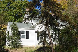
Zarephath is an unincorporated community and census-designated place (CDP) and located in Franklin Township, in Somerset County, in the U.S. state of New Jersey, about 15 mi (24 km) north of Princeton. As of the 2020 United States census, the CDP's population was 69, an increase of 32 (+86.5%) from the 37 enumerated at the 2010 census.

Six Mile Run is an unincorporated community and census-designated place (CDP) located in Franklin Township, in Somerset County, in the U.S. state of New Jersey. As of the 2010 United States Census, the CDP's population was 3,184.

<span class="mw-page-title-main">Middlebush, New Jersey</span> Populated place in Somerset County, New Jersey, US

Middlebush is an unincorporated community and census-designated place (CDP) located in Franklin Township, in Somerset County, in the U.S. state of New Jersey. As of the 2010 United States Census, the CDP's population was 2,326. It is perhaps most distinguished as being the host section for Franklin Township's municipal complex.

<span class="mw-page-title-main">Blackwells Mills Canal House</span> American property built c. 1830s

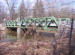
The Blackwells Mills Canal House is located at Blackwells Mills Road and Canal Road in Franklin Township, Somerset County, New Jersey, United States, on the Delaware and Raritan Canal. Across the canal is Blackwells Mills, New Jersey.

<span class="mw-page-title-main">East Millstone, New Jersey</span> Populated place in Somerset County, New Jersey, US

East Millstone is an unincorporated community and census-designated place (CDP) located in Franklin Township in Somerset County, in the U.S. state of New Jersey.

<span class="mw-page-title-main">Neshanic Station, New Jersey</span> Place in Somerset County, New Jersey, United States

Neshanic Station is an unincorporated community and census-designated place (CDP) located within Branchburg and extending into Hillsborough Township, Somerset County, in the U.S. state of New Jersey. In 2016 most of the village was listed on the National Register of Historic Places as the Neshanic Station Historic District.

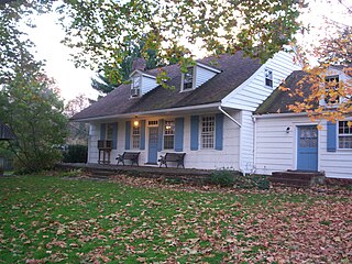
Weston is an unincorporated community and census-designated place (CDP) located in Franklin Township, in Somerset County, in the U.S. state of New Jersey. As of the 2010 United States Census, the CDP's population was 1,235.

<span class="mw-page-title-main">Finderne, New Jersey</span> Populated place in Somerset County, New Jersey, US

Finderne is an unincorporated community and census-designated place (CDP) located within Bridgewater Township, in Somerset County, in the U.S. state of New Jersey. As of the 2010 United States Census, the CDP's population was 5,600.

<span class="mw-page-title-main">Ten Mile Run, New Jersey</span> Populated place in Somerset County, New Jersey, US

Ten Mile Run is an unincorporated community and census-designated place (CDP) located in Franklin Township, in Somerset County, in the U.S. state of New Jersey. As of the 2010 United States Census, the CDP's population was 1,959.

<span class="mw-page-title-main">Finesville, New Jersey</span> Populated place in Warren County, New Jersey, US

Finesville is an unincorporated community and census-designated place (CDP) located within Pohatcong Township in Warren County, in the U.S. state of New Jersey. The CDP was defined as part of the 2010 United States Census. As of the 2010 Census, the CDP's population was 175.

<span class="mw-page-title-main">Washington Crossing, New Jersey</span> Populated place in Mercer County, New Jersey, US

Washington Crossing, New Jersey is an unincorporated community and census-designated place (CDP) located within Hopewell Township in Mercer County, in the U.S. state of New Jersey. The CDP and surrounding Hopewell Township lie on the eastern flank of the Washington Crossing Bridge spanning the Delaware River. Washington Crossing State Park is located adjacent to the community in New Jersey whilie across the river lies Washington Crossing Historic Park in Washington Crossing, Pennsylvania. As of the 2020 United States census, the CDP's population was 371.

References

  1. 1 2 3 Gazetteer of New Jersey Places, United States Census Bureau. Accessed July 21, 2016.
  2. 1 2 US Gazetteer files: 2010, 2000, and 1990, United States Census Bureau. Accessed September 4, 2014.
  3. "ArcGIS REST Services Directory". United States Census Bureau. Retrieved October 11, 2022.
  4. 1 2 "Griggstown Census Designated Place". Geographic Names Information System . United States Geological Survey, United States Department of the Interior.
  5. 1 2 Census Data Explorer: Griggstown CDP, New Jersey, United States Census Bureau. Accessed June 15, 2023.
  6. Geographic Codes Lookup for New Jersey, Missouri Census Data Center. Accessed June 9, 2023.
  7. State of New Jersey Census Designated Places - BVP20 - Data as of January 1, 2020, United States Census Bureau. Accessed December 1, 2022.
  8. GCT-PH1 - Population, Housing Units, Area, and Density: 2010 - County -- County Subdivision and Place from the 2010 Census Summary File 1 for Somerset County, New Jersey Archived 2020-02-12 at archive.today , United States Census Bureau. Accessed February 11, 2013.
  9. 2006-2010 American Community Survey Geography for New Jersey, United States Census Bureau. Accessed February 11, 2013.
  10. New Jersey: 2010 - Population and Housing Unit Counts - 2010 Census of Population and Housing (CPH-2-32), United States Census Bureau, August 2012. Accessed February 11, 2013.
  11. Locality Search, State of New Jersey. Accessed April 18, 2015.
  12. 1 2 3 4 5 DP-1 - Profile of General Population and Housing Characteristics: 2010 Demographic Profile Data for Griggstown CDP, New Jersey Archived 2020-02-12 at archive.today , United States Census Bureau. Accessed August 28, 2012.
  13. Shackleford, James (August 15, 2011). "The Legend of the Ghost Cow". South Brunswick, NJ Patch. Retrieved June 1, 2023.
  14. Chirco, Vicki. The Legend of the Griggstown Cow", New Jersey Division of Parks and Forestry. Accessed June 1, 2023.
  15. 1 2 William B. Brahms, Franklin Township, Somerset County, NJ: A History, FTPL; ISBN   0-9668586-0-3
  16. "National Register Information System  (#84002798)". National Register of Historic Places . National Park Service. November 2, 2013.
  17. "New Jersey and National Registers of Historic Places – Somerset County" (PDF). New Jersey Department of Environmental Protection – Historic Preservation Office. September 28, 2021. p. 6.
  18. Gibson, David; Bauer, Steven (September 1983). "National Register of Historic Places Inventory/Nomination: Griggstown Historic District". National Park Service. With accompanying 50 photos
  19. History of Franklin Township, NY-NJ-CT Botany Online. Accessed September 22, 2007. "1777:... In Griggstown John Honeyman (with a home that still stands at the foot of Bunker Hill Road and Canal Road) posed as a cattle-trader sympathetic to the British in order to spy on them. Honeyman's information helped Washington plan the surprise attack on Trenton."
  20. "Making history in Griggstown". Princeton Packet . November 27, 2007. Retrieved July 24, 2008. Two presentations by John Allen, president of the Griggstown Historical Society, were made. Mark Alan Hewitt, project architect, received an autographed copy of Moy Sand & Gravel by Pulitzer Prize-winning poet Paul Muldoon, a Griggstown resident.[ permanent dead link ]