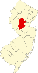
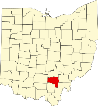
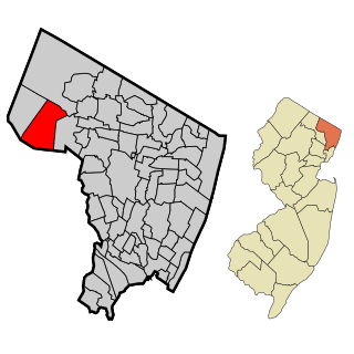
[3] Name on the Register [4] Image Date listed [5] Location City or town Description 1 Alward Farmhouse Alward Farmhouse March 13, 1986 (# 86000388 40 Mt. Airy Rd. 40°41′39″N 74°34′34″W / 40.694167°N 74.576111°W / 40.694167; -74.576111 (Alward Farmhouse ) Basking Ridge 2 Baker–Duderstadt Farm Baker–Duderstadt Farm November 26, 2008 (# 08001109 30 DuBois Road 40°38′03″N 74°29′50″W / 40.634075°N 74.497361°W / 40.634075; -74.497361 (Baker–Duderstadt Farm ) Warren Township 3 Basking Ridge Classical School Basking Ridge Classical School July 21, 1976 (# 76001185 15 W. Oak Street 40°42′24″N 74°33′00″W / 40.706667°N 74.550000°W / 40.706667; -74.550000 (Basking Ridge Classical School ) Basking Ridge 4 Bedens Brook Bridge Bedens Brook Bridge February 17, 1994 (# 94000010 Opossum Rd., 0.1 miles (0.16 km) south of Orchard Rd., over Bedens's Brook, Montgomery Township 40°24′56″N 74°39′51″W / 40.415556°N 74.664167°W / 40.415556; -74.664167 (Bedens Brook Bridge ) Montgomery Township 5 Bedens Brook Road Bridge Bedens Brook Road Bridge February 18, 1994 (# 94000011 Beden's Brook Rd., 0.1 miles (0.16 km) east of Province Line Rd., over branch of Beden's Brook, Montgomery Township 40°23′40″N 74°43′47″W / 40.394444°N 74.729722°W / 40.394444; -74.729722 (Bedens Brook Road Bridge ) Stoutsburg 6 Bernardsville Station Bernardsville Station June 22, 1984 (# 84002786 U.S. Route 202 40°43′01″N 74°34′18″W / 40.716944°N 74.571667°W / 40.716944; -74.571667 (Bernardsville Station ) Bernardsville part of the Operating Passenger Railroad Stations TR 7 Blawenburg Historic District Blawenburg Historic District December 7, 1990 (# 88000632 Georgetown-Franklin Turnpike/CR 588, Great Road/CR 601, and Mountain View Road 40°24′29″N 74°42′09″W / 40.408056°N 74.7025°W / 40.408056; -74.7025 (Blawenburg Historic District ) Blawenburg Includes Reformed Dutch Church of Blawenburg 8 Boudinot–Southard Farmstead Boudinot–Southard Farmstead December 18, 2009 (# 09001101 135 N. Maple Avenue 40°42′55″N 74°32′32″W / 40.715278°N 74.542222°W / 40.715278; -74.542222 (Boudinot–Southard Farmstead ) Bernards Township Known as the Ross Farm 9 Bound Brook Station Bound Brook Station June 22, 1984 (# 84002787 E. Main St. 40°33′39″N 74°31′51″W / 40.560833°N 74.530833°W / 40.560833; -74.530833 (Bound Brook Station ) Bound Brook part of the Operating Passenger Railroad Stations TR 10 Bridgepoint Historic District Bridgepoint Historic District June 10, 1975 (# 75001161 North of Rocky Hill along Bridgepoint and Dead Tree Run roads 40°25′46″N 74°38′55″W / 40.429444°N 74.648611°W / 40.429444; -74.648611 (Bridgepoint Historic District ) Montgomery Township 11 Brook Theater Brook Theater May 5, 2014 (# 14000190 10 Hamilton Street 40°33′43″N 74°31′48″W / 40.5619705°N 74.529901°W / 40.5619705; -74.529901 (Brook Theater ) Bound Brook Known as Brook Arts Center 12 Cat Tail Brook Bridge Cat Tail Brook Bridge August 1, 1979 (# 79001520 Northwest of Rocky Hill on Montgomery Rd 40°26′28″N 74°44′37″W / 40.441111°N 74.743611°W / 40.441111; -74.743611 (Cat Tail Brook Bridge ) Rocky Hill 13 Clover Hill Historic District Clover Hill Historic District September 29, 1980 (# 80002492 Amwell and Wertsville-Clover Hill Roads 40°29′14″N 74°47′01″W / 40.487222°N 74.783611°W / 40.487222; -74.783611 (Clover Hill Historic District ) Clover Hill Extends into Hunterdon County 14 Coffee House Coffee House November 7, 1977 (# 77000906 214 N. Maple Ave. 40°43′11″N 74°32′30″W / 40.719722°N 74.541667°W / 40.719722; -74.541667 (Coffee House ) Basking Ridge 15 Moses Craig Limekilns Moses Craig Limekilns April 11, 2019 (# 100003610 122 Main Street 40°42′44″N 74°39′27″W / 40.7122°N 74.6575°W / 40.7122; -74.6575 (Moses Craig Limekilns ) Peapack-Gladstone 16 Delaware and Raritan Canal Delaware and Raritan Canal May 11, 1973 (# 73001105 Follows the Delaware River to Trenton, then E to New Brunswick 40°32′40″N 75°02′50″W / 40.544444°N 75.047222°W / 40.544444; -75.047222 (Delaware and Raritan Canal ) Somerville 17 East Millstone Historic District East Millstone Historic District March 17, 1983 (# 83001613 Amwell Road and Delaware & Raritan Canal 40°30′04″N 74°34′50″W / 40.501111°N 74.580556°W / 40.501111; -74.580556 (East Millstone Historic District ) East Millstone 18 Elmendorf House Elmendorf House April 16, 1992 (# 92000378 1246 Millstone River Rd., Hillsborough Township 40°30′43″N 74°35′17″W / 40.511944°N 74.588056°W / 40.511944; -74.588056 (Elmendorf House ) Millstone 19 Far Hills Station Far Hills Station June 22, 1984 (# 84002789 U.S. Route 202 40°41′08″N 74°38′03″W / 40.685556°N 74.634167°W / 40.685556; -74.634167 (Far Hills Station ) Far Hills part of the Operating Passenger Railroad Stations TR 20 Franklin Corners Historic District Franklin Corners Historic District May 12, 1975 (# 75001159 Along Hardscrabble and Childs Roads 40°43′59″N 74°32′48″W / 40.733056°N 74.546667°W / 40.733056; -74.546667 (Franklin Corners Historic District ) Franklin Corners 21 General John Frelinghuysen House General John Frelinghuysen House March 4, 1971 (# 71000513 Somerset St. and Wyckoff Ave. 40°34′05″N 74°37′46″W / 40.568056°N 74.629444°W / 40.568056; -74.629444 (General John Frelinghuysen House ) Raritan 22 Gladstone Station Gladstone Station June 22, 1984 (# 84002792 Main St. 40°43′12″N 74°39′58″W / 40.72°N 74.666111°W / 40.72; -74.666111 (Gladstone Station ) Gladstone part of the Operating Passenger Railroad Stations TR 23 Griggstown Historic District Griggstown Historic District August 2, 1984 (# 84002798 Roughly Canal Road from Old Georgetown Road to Ten Mile Run 40°25′46″N 74°36′52″W / 40.429444°N 74.614444°W / 40.429444; -74.614444 (Griggstown Historic District ) Griggstown 24 Dirck Gulick House Dirck Gulick House December 11, 2003 (# 03001285 506 Belle Mead-Blawenburg Road 40°26′54″N 74°41′24″W / 40.448333°N 74.690000°W / 40.448333; -74.690000 (Dirck Gulick House ) Montgomery Township 25 Hamilton Farm Stable Complex Hamilton Farm Stable Complex May 18, 2018 (# 100001243 1040 Pottersville Rd. 40°43′08″N 74°41′15″W / 40.7190°N 74.6876°W / 40.7190; -74.6876 (Hamilton Farm Stable Complex ) Bedminster 26 Higginsville Road Bridges Higginsville Road Bridges August 10, 2000 (# 00000916 Higginsville Rd. at the South Branch of the Raritan River 40°30′33″N 74°47′08″W / 40.509167°N 74.785556°W / 40.509167; -74.785556 (Higginsville Road Bridges ) Hillsborough 27 Huff House and Farmstead Huff House and Farmstead November 7, 1976 (# 76001186 River Road at the South Branch Raritan River , near Flagtown 40°31′02″N 74°43′21″W / 40.517222°N 74.7225°W / 40.517222; -74.7225 (Huff House and Farmstead ) Hillsborough Township 28 Kennedy–Martin–Stelle Farmstead Kennedy–Martin–Stelle Farmstead May 5, 2004 (# 03000868 450 King George Road 40°39′29″N 74°31′44″W / 40.658056°N 74.528889°W / 40.658056; -74.528889 (Kennedy–Martin–Stelle Farmstead ) Bernards Township 29 King's Highway Historic District King's Highway Historic District December 21, 2000 (# 00001493 NJ 27, US 206 40°22′21″N 74°37′06″W / 40.3725°N 74.618333°W / 40.3725; -74.618333 (King's Highway Historic District ) Franklin Extends into Mercer and Middlesex Counties 30 Kingston Mill Historic District Kingston Mill Historic District April 10, 1986 (# 86000707 Roughly bounded by Herrontown, River, Princeton-Kingston Roads 40°22′28″N 74°37′34″W / 40.374444°N 74.626111°W / 40.374444; -74.626111 (Kingston Mill Historic District ) Franklin Extends into Mercer and Middlesex Counties, includes Kingston Bridge 31 Kingston Village Historic District Kingston Village Historic District January 11, 1990 (# 89002163 Roughly New Jersey Route 27 from Raymond Rd. to Delaware & Raritan Canal, Church St., Laurel Ave., Heathcote Brook Rd., & Academy St. 40°22′33″N 74°36′48″W / 40.375833°N 74.613333°W / 40.375833; -74.613333 (Kingston Village Historic District ) Kingston Extends into Middlesex County 32 Kirch–Ford House Kirch–Ford House October 20, 1988 (# 88002033 1 Reinman Road 40°38′03″N 74°30′11″W / 40.634167°N 74.503056°W / 40.634167; -74.503056 (Kirch–Ford House ) Warren Township 33 Lamington Historic District Lamington Historic District June 21, 1984 (# 84002802 Lamington, Black River, Rattlesnake Bridge, and Cowperthwaite Roads 40°39′38″N 74°43′03″W / 40.660566°N 74.717500°W / 40.660566; -74.717500 (Lamington Historic District ) Lamington 34 Liberty Corner Historic District Liberty Corner Historic District October 11, 1991 (# 91001477 Roughly, the junction of Church Street and Valley and Lyons Roads, and the area west and southwest 40°39′54″N 74°34′51″W / 40.665000°N 74.580833°W / 40.665000; -74.580833 (Liberty Corner Historic District ) Liberty Corner 35 Alexander and James Linn Homestead Alexander and James Linn Homestead October 27, 1988 (# 88002057 U.S. Route 202 (Mine Brook Road), between Sunnybranch and Lake Roads 40°41′31″N 74°37′48″W / 40.691944°N 74.63°W / 40.691944; -74.63 (Alexander and James Linn Homestead ) Far Hills 36 Lyons Station Lyons Station June 22, 1984 (# 84002805 Lyons Rd. 40°41′05″N 74°33′00″W / 40.684722°N 74.55°W / 40.684722; -74.55 (Lyons Station ) Lyons part of the Operating Passenger Railroad Stations TR 37 Lyons Veterans Administration Hospital Historic District Lyons Veterans Administration Hospital Historic District July 3, 2013 (# 13000461 151 Knollcroft Road 40°40′11″N 74°33′19″W / 40.6696°N 74.5552°W / 40.6696; -74.5552 (Lyons Veterans Administration Hospital Historic District ) Lyons Known as Lyons VA Medical Center , part of United States Second Generation Veterans Hospitals MPS 38 Maplewood Maplewood August 24, 2000 (# 00000960 Burnt Hill Road at Rock Brook 40°24′50″N 74°41′02″W / 40.413889°N 74.683889°W / 40.413889; -74.683889 (Maplewood ) Montgomery Township destroyed by fire in 2011 39 McDonald's–Kline's Mill McDonald's–Kline's Mill March 9, 1987 (# 87000410 Address Restricted Bedminster 40 The Meadows The Meadows December 4, 1973 (# 73001134 1289 Easton Ave. 40°31′22″N 74°29′36″W / 40.522778°N 74.493333°W / 40.522778; -74.493333 (The Meadows ) Franklin Known as Van Wickle House 41 Middlebrook Encampment Site Middlebrook Encampment Site July 3, 1975 (# 75001160 Middlebrook Road 40°34′45″N 74°32′16″W / 40.579167°N 74.537778°W / 40.579167; -74.537778 (Middlebrook Encampment Site ) Bridgewater Township 42 Middlebush Village Historic District Middlebush Village Historic District April 24, 2007 (# 07000354 Amwell Road, S. Middlebush Road, Railroad Avenue, Olcott Street, and Debow Street 40°29′44″N 74°31′44″W / 40.495611°N 74.5289°W / 40.495611; -74.5289 (Middlebush Village Historic District ) Franklin Includes Middlebush Reformed Church 43 Millstone Historic District Millstone Historic District September 13, 1976 (# 76001188 Amwell and River Roads 40°29′56″N 74°35′18″W / 40.498889°N 74.588333°W / 40.498889; -74.588333 (Millstone Historic District ) Millstone 44 Millstone Valley Agricultural District Millstone Valley Agricultural District August 10, 1977 (# 77000907 South of Millstone on River Road 40°28′52″N 74°34′50″W / 40.481111°N 74.580556°W / 40.481111; -74.580556 (Millstone Valley Agricultural District ) Hillsborough 45 Morristown National Historical Park Morristown National Historical Park October 15, 1966 (# 66000053 Jockey Hollow Road 40°44′53″N 74°33′34″W / 40.748056°N 74.559444°W / 40.748056; -74.559444 (Morristown National Historical Park ) Bernardsville New Jersey Brigade Encampment Site in Somerset County 46 Mount Bethel Baptist Meetinghouse Mount Bethel Baptist Meetinghouse June 3, 1976 (# 76001187 About 2 miles (3.2 km) north of Martinsville off Interstate 78 40°38′17″N 74°30′53″W / 40.638056°N 74.514722°W / 40.638056; -74.514722 (Mount Bethel Baptist Meetinghouse ) Warren Township 47 Mount Zion African Methodist Episcopal Church Mount Zion African Methodist Episcopal Church June 7, 2021 (# 100006611 189 Hollow Road 40°25′02″N 74°43′16″W / 40.4172°N 74.7212°W / 40.4172; -74.7212 (Mount Zion African Methodist Episcopal Church ) Montgomery Township Home to the Stoutsburg Sourland African American Museum 48 Neshanic Historic District Neshanic Historic District August 1, 1979 (# 79001519 Amwell and Zion Roads 40°29′54″N 74°43′12″W / 40.4983°N 74.72°W / 40.4983; -74.72 (Neshanic Historic District ) Neshanic 49 Neshanic Mills Neshanic Mills January 9, 1978 (# 78001797 River Road and Mill Lane 40°30′31″N 74°43′33″W / 40.5086°N 74.7258°W / 40.5086; -74.7258 (Neshanic Mills ) Neshanic Station 50 Neshanic Station Historic District Neshanic Station Historic District February 8, 2016 (# 15001051 Maple Avenue, Fairview Drive; Elm, Olive, Pearl, Main, and Marshall Streets; Woodfern Road 40°30′31″N 74°43′54″W / 40.5086°N 74.7317°W / 40.5086; -74.7317 (Neshanic Station Historic District ) Neshanic Station 51 North Branch Historic District North Branch Historic District April 16, 2012 (# 12000209 Easton Turnpike, Vanderveer Avenue, Burnt Mill and Station Roads 40°36′10″N 74°40′42″W / 40.6028°N 74.6783°W / 40.6028; -74.6783 (North Branch Historic District ) North Branch 52 Olcott Avenue Historic District Olcott Avenue Historic District November 20, 2009 (# 09000940 Portions of Olcott, Childsworth, and Highview Avenues, and Church Street 40°43′18″N 74°34′03″W / 40.7217°N 74.5675°W / 40.7217; -74.5675 (Olcott Avenue Historic District ) Bernardsville 53 Old Dutch Parsonage Old Dutch Parsonage January 25, 1971 (# 71000514 65 Washington Place 40°34′05″N 74°37′23″W / 40.5681°N 74.6231°W / 40.5681; -74.6231 (Old Dutch Parsonage ) Somerville 54 Old Stone Arch Bridge Old Stone Arch Bridge June 27, 2008 (# 08000550 Railroad Ave., approximately 194 feet east of South Main St. 40°33′37″N 74°31′36″W / 40.5604°N 74.5267°W / 40.5604; -74.5267 (Old Stone Arch Bridge ) Bound Brook 55 John Parker Tavern John Parker Tavern December 14, 1978 (# 78001796 2 Morristown Road 40°43′07″N 74°34′06″W / 40.7186°N 74.5683°W / 40.7186; -74.5683 (John Parker Tavern ) Bernardsville 56 Pluckemin Village Historic District Pluckemin Village Historic District July 26, 1982 (# 82003303 U.S. Route 206 and Burnt Mills Road 40°38′48″N 74°38′24″W / 40.6467°N 74.6400°W / 40.6467; -74.6400 (Pluckemin Village Historic District ) Pluckemin 57 Pluckemin Continental Artillery Cantonment Site Pluckemin Continental Artillery Cantonment Site March 14, 2008 (# 08000180 Junction of U.S. Routes 202 and 206 , north of River Rd., Bedminster Twp. 40°40′02″N 74°39′05″W / 40.6672°N 74.6514°W / 40.6672; -74.6514 (Pluckemin Continental Artillery Cantonment Site ) Pluckemin 58 Pottersville Village Historic District Pottersville Village Historic District September 18, 1990 (# 90001475 Properties fronting on Black River, Pottersville, McCann Mill and Hacklebarney Roads, Fairmount Road East and High Street 40°42′52″N 74°43′15″W / 40.7144°N 74.7208°W / 40.7144; -74.7208 (Pottersville Village Historic District ) Pottersville Extends into Hunterdon and Morris Counties 59 Presbyterian Church at Bound Brook Presbyterian Church at Bound Brook August 28, 2007 (# 07000876 409 Mountain Ave. 40°34′01″N 74°31′52″W / 40.5669°N 74.5311°W / 40.5669; -74.5311 (Presbyterian Church at Bound Brook ) Bound Brook 60 Presbyterian Church in Basking Ridge Presbyterian Church in Basking Ridge December 31, 1974 (# 74001190 6 E. Oak St. 40°42′26″N 74°32′39″W / 40.7072°N 74.5442°W / 40.7072; -74.5442 (Presbyterian Church in Basking Ridge ) Basking Ridge 61 Raritan Bridge Raritan Bridge November 12, 1992 (# 92001526 Nevius Street over the Raritan River, Raritan Borough and Hillsborough Township 40°33′53″N 74°38′09″W / 40.5647°N 74.6358°W / 40.5647; -74.6358 (Raritan Bridge ) Raritan Known as Nevius Street Bridge 62 Raritan Station Raritan Station June 22, 1984 (# 84002824 Anderson and Thompson Sts. 40°34′14″N 74°38′04″W / 40.5706°N 74.6344°W / 40.5706; -74.6344 (Raritan Station ) Raritan part of the Operating Passenger Railroad Stations TR 63 Reformed Dutch Church of Blawenburg Reformed Dutch Church of Blawenburg September 5, 1985 (# 85002004 424 CR 518 40°24′30″N 74°41′57″W / 40.408333°N 74.699167°W / 40.408333; -74.699167 (Reformed Dutch Church of Blawenburg ) Blawenburg Known as Blawenburg Reformed Church 64 Relief Hose Company No. 2 Engine House Relief Hose Company No. 2 Engine House December 14, 2000 (# 00001466 16 Anderson Street 40°34′07″N 74°38′03″W / 40.568611°N 74.634167°W / 40.568611; -74.634167 (Relief Hose Company No. 2 Engine House ) Raritan 65 Reynolds–Scherman House Reynolds–Scherman House April 29, 1989 (# 89000298 71 Hardscrabble Road 40°44′22″N 74°33′27″W / 40.739444°N 74.5575°W / 40.739444; -74.5575 (Reynolds–Scherman House ) Bernardsville 66 River Road Historic Rural District River Road Historic Rural District March 21, 1991 (# 91000256 Millstone River Road from Hillsborough Road to Van Horne Road 40°26′16″N 74°37′09″W / 40.437778°N 74.619167°W / 40.437778; -74.619167 (River Road Historic Rural District ) Hillsborough , Montgomery 67 Daniel Robert House Daniel Robert House March 5, 2008 (# 08000137 25 West End Avenue 40°34′14″N 74°37′11″W / 40.570556°N 74.619722°W / 40.570556; -74.619722 (Daniel Robert House ) Somerville Serves as Somerville Borough Hall and Somerville Public Library 68 Rock Brook Bridge Rock Brook Bridge February 18, 1994 (# 94000012 Junction of Long Hill and Dutchtown-Zion Rds. over Cat Tail Brook, Montgomery and Hillsborough Townships 40°26′22″N 74°44′23″W / 40.439444°N 74.739722°W / 40.439444; -74.739722 (Rock Brook Bridge ) Zion 69 Rockingham Rockingham December 18, 1970 (# 70000394 84 Laurel Avenue (Route 603) 40°23′03″N 74°37′08″W / 40.384167°N 74.618889°W / 40.384167; -74.618889 (Rockingham ) Franklin Judge John Berrien House, George Washington's Headquarters in 1783, originally at Rocky Hill , relocated near Kingston in 2001 70 Rocky Hill Historic District Rocky Hill Historic District July 8, 1982 (# 82003304 Washington Street; Montgomery, Crescent, and Princeton Avenues 40°24′01″N 74°38′15″W / 40.400278°N 74.637500°W / 40.400278; -74.637500 (Rocky Hill Historic District ) Rocky Hill 71 St. Bernard's Church and Parish House St. Bernard's Church and Parish House September 6, 2006 (# 06000761 88 Claremont Road 40°43′20″N 74°34′21″W / 40.722222°N 74.5725°W / 40.722222; -74.5725 (St. Bernard's Church and Parish House ) Bernardsville 72 St. John's Church Complex St. John's Church Complex September 15, 2003 (# 03000933 154–158 W. High Street 40°34′20″N 74°37′03″W / 40.572248°N 74.617576°W / 40.572248; -74.617576 (St. John's Church Complex ) Somerville Includes St. John's Episcopal Church, rectory, and parish hall 73 Six Mile Run Historic District Six Mile Run Historic District October 25, 1995 (# 95001191 Roughly bounded by Grouse Road, Amwell Road, Bennetts Lane, New Jersey Route 27 , Bunker Hill Road and the Millstone River 40°27′48″N 74°33′29″W / 40.463333°N 74.558056°W / 40.463333; -74.558056 (Six Mile Run Historic District ) Franklin 74 Six Mile Run Reformed Church Six Mile Run Reformed Church December 18, 2009 (# 09001102 3037 New Jersey Route 27 , Franklin Park 40°26′19″N 74°32′10″W / 40.438611°N 74.536111°W / 40.438611; -74.536111 (Six Mile Run Reformed Church ) Franklin 75 Smalley–Wormser House Smalley–Wormser House October 19, 1978 (# 78001798 West of Plainfield at 84 Mountain Ave. 40°39′30″N 74°28′28″W / 40.658333°N 74.474444°W / 40.658333; -74.474444 (Smalley–Wormser House ) Warren Township 76 J. Harper Smith Mansion J. Harper Smith Mansion December 31, 1998 (# 98001572 228 Altamont Place 40°34′29″N 74°37′14″W / 40.574722°N 74.620639°W / 40.574722; -74.620639 (J. Harper Smith Mansion ) Somerville 77 Somerset Courthouse Green Somerset Courthouse Green September 7, 1989 (# 89001216 Roughly E. Main St. from Grove St. to N. Bridge St. 40°34′05″N 74°36′40″W / 40.568056°N 74.611111°W / 40.568056; -74.611111 (Somerset Courthouse Green ) Somerville 78 South Branch Historic District South Branch Historic District December 13, 1977 (# 77000908 River Road and Orchard Drive 40°32′43″N 74°41′46″W / 40.545278°N 74.696111°W / 40.545278; -74.696111 (South Branch Historic District ) South Branch 79 South Branch Schoolhouse South Branch Schoolhouse March 30, 2005 (# 05000221 2120 South Branch Road 40°32′53″N 74°42′01″W / 40.548056°N 74.700278°W / 40.548056; -74.700278 (South Branch Schoolhouse ) Branchburg 80 Staats House Staats House December 4, 2002 (# 02001483 17 Von Steuben Lane 40°33′06″N 74°31′16″W / 40.551667°N 74.521111°W / 40.551667; -74.521111 (Staats House ) South Bound Brook Headquarters of General Friedrich Wilhelm von Steuben during the second Middlebrook encampment , 1778–79 81 Lord Stirling Manor Site Lord Stirling Manor Site May 22, 1978 (# 78001795 Southeast of Basking Ridge at 96 Lord Stirling Road 40°41′39″N 74°31′50″W / 40.694167°N 74.530556°W / 40.694167; -74.530556 (Lord Stirling Manor Site ) Basking Ridge 82 Andrew Ten Eyck House Andrew Ten Eyck House May 6, 2004 (# 04000391 671 Old York Road 40°33′25″N 74°41′32″W / 40.556944°N 74.692222°W / 40.556944; -74.692222 (Andrew Ten Eyck House ) Branchburg 83 Tulipwood Tulipwood September 9, 2005 (# 05000966 1165 Hamilton St. 40°29′20″N 74°29′41″W / 40.488889°N 74.494722°W / 40.488889; -74.494722 (Tulipwood ) Somerset Known as Whitehaven Farm 84 Vail–Trust House Vail–Trust House October 7, 2008 (# 08000972 255 Greenbrook Road 40°35′19″N 74°29′42″W / 40.588611°N 74.495°W / 40.588611; -74.495 (Vail–Trust House ) Green Brook 85 Van Der Veer–Harris House Van Der Veer–Harris House March 12, 2008 (# 08000181 344 U.S. Route 206 (Hillsborough Township) 40°30′39″N 74°38′04″W / 40.510833°N 74.634444°W / 40.510833; -74.634444 (Van Der Veer–Harris House ) Woods Tavern 86 Van Horne House Van Horne House March 8, 2002 (# 02000133 941 East Main Street 40°33′42″N 74°33′05″W / 40.561667°N 74.551389°W / 40.561667; -74.551389 (Van Horne House ) Bridgewater Township Headquarters of General William Alexander, Lord Stirling during the second Middlebrook encampment , 1778–79 87 Van Veghten House Van Veghten House October 10, 1979 (# 79003253 9 Van Veghten Drive 40°33′25″N 74°35′18″W / 40.556944°N 74.588333°W / 40.556944; -74.588333 (Van Veghten House ) Bridgewater Township Headquarters of Quartermaster General Nathanael Greene during the second Middlebrook encampment , 1778–79 88 Jacobus Vanderveer House Jacobus Vanderveer House September 29, 1995 (# 95001137 Junction of U.S. Route 202 and U.S. Route 206 , north of River Rd., Bedminster Twp. 40°40′00″N 74°38′42″W / 40.666667°N 74.645000°W / 40.666667; -74.645000 (Jacobus Vanderveer House ) Bedminster Includes museum for Pluckemin Continental Artillery Cantonment Site 89 Van Derventer–Brunson House Van Derventer–Brunson House October 27, 2004 (# 04001191 614 Greenbrook Road 40°36′34″N 74°27′22″W / 40.609444°N 74.456111°W / 40.609444; -74.456111 (Van Derventer–Brunson House ) North Plainfield Known as Vermeule Mansion 90 Dr. John Vermeule House Dr. John Vermeule House February 20, 2013 (# 13000024 223 Rock Avenue 40°36′27″N 74°27′45″W / 40.607371°N 74.462396°W / 40.607371; -74.462396 (Dr. John Vermeule House ) Green Brook 91 Vosseller's–Castner's–Allen's Tavern Vosseller's–Castner's–Allen's Tavern January 23, 1986 (# 86000133 664 Foothill Road 40°36′27″N 74°37′07″W / 40.607500°N 74.618611°W / 40.607500; -74.618611 (Vosseller's–Castner's–Allen's Tavern ) Bridgewater Township Known as Jacob Vosseller House 92 Wallace House Wallace House December 2, 1970 (# 70000395 38 Washington Place 40°34′08″N 74°37′19″W / 40.568889°N 74.621944°W / 40.568889; -74.621944 (Wallace House ) Somerville Headquarters of General George Washington during the second Middlebrook encampment , 1778–79 93 Washington Park Historic District Washington Park Historic District April 9, 1987 (# 87000603 Roughly bounded by Green Brook Rd., Grove Ave., E. Front St., and Geraud Ave. 40°37′04″N 74°26′07″W / 40.617778°N 74.435278°W / 40.617778; -74.435278 (Washington Park Historic District ) North Plainfield 94 West End Hose Company Number 3 West End Hose Company Number 3 July 17, 2002 (# 02000808 15 North Doughty Avenue 40°33′49″N 74°37′06″W / 40.563611°N 74.618333°W / 40.563611; -74.618333 (West End Hose Company Number 3 ) Somerville