The Global 200 is the list of ecoregions identified by the World Wide Fund for Nature (WWF), the global conservation organization, as priorities for conservation. According to WWF, an ecoregion is defined as a "relatively large unit of land or water containing a characteristic set of natural communities that share a large majority of their species dynamics, and environmental conditions". For example, based on their levels of endemism, Madagascar gets multiple listings, ancient Lake Baikal gets one, and the North American Great Lakes get none.
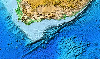
The Agulhas Bank is a broad, shallow part of the southern African continental shelf which extends up to 250 km (160 mi) south of Cape Agulhas before falling steeply to the abyssal plain.

Marine ecosystems are the largest of Earth's aquatic ecosystems and exist in waters that have a high salt content. These systems contrast with freshwater ecosystems, which have a lower salt content. Marine waters cover more than 70% of the surface of the Earth and account for more than 97% of Earth's water supply and 90% of habitable space on Earth. Seawater has an average salinity of 35 parts per thousand of water. Actual salinity varies among different marine ecosystems. Marine ecosystems can be divided into many zones depending upon water depth and shoreline features. The oceanic zone is the vast open part of the ocean where animals such as whales, sharks, and tuna live. The benthic zone consists of substrates below water where many invertebrates live. The intertidal zone is the area between high and low tides. Other near-shore (neritic) zones can include mudflats, seagrass meadows, mangroves, rocky intertidal systems, salt marshes, coral reefs, lagoons. In the deep water, hydrothermal vents may occur where chemosynthetic sulfur bacteria form the base of the food web.

Tweed–Moreton, also known as the Central Eastern Shelf Transition, is a marine biogeographic region of eastern Australia.

The following outline is provided as an overview of and introduction to Oceanography.

As with other countries, the 200 nautical miles (370 km) exclusive economic zone (EEZ) off the coast of the United States gives its fishing industry special fishing rights. It covers 11.4 million square kilometres, which is the second largest zone in the world, exceeding the land area of the United States.

The marine ecoregions of the South African exclusive economic zone are a set of geographically delineated regions of similar ecological characteristics on a fairly broad scale, covering the exclusive economic zone along the South African coast.
The marine protected areas of South Africa are in an area of coastline or ocean within the exclusive economic zone (EEZ) of the Republic of South Africa that is protected in terms of specific legislation for the benefit of the environment and the people who live in and use it. An MPA is a place where marine life can thrive under less pressure than unprotected areas. They are like underwater parks, and this healthy environment can benefit neighbouring areas.

The Marine biodiversity of South Africa is the variety of living organisms that live in the seas off the coast of South Africa. It includes genetic, species and ecosystems biodiversity in a range of habitats spread over a range of ecologically varied regions, influenced by the geomorphology of the seabed and circulation of major and local water masses, which distribute both living organisms and nutrients in complex and time-variable patterns.
The East African coral coast is a marine ecoregion along the eastern coast of Africa. It extends along the coasts of Kenya, Tanzania, and northern Mozambique, from Lamu in Kenya to Angoche in Mozambique. It adjoins the Northern Monsoon Current Coast ecoregion to the north, and the Bight of Sofala/Swamp Coast ecoregion to the south.
The Bight of Sofala/Swamp Coast is a marine ecoregion along the eastern coast of Africa, characterized by extensive mangrove swamps and coastal wetlands. It extends along the coast of Mozambique, from Angoche to the Bazaruto Archipelago. It adjoins the East African coral coast ecoregion to the north, and the Delagoa ecoregion to the south.
The Northern Monsoon Current coast is a marine ecoregion along the eastern coast of Africa. It extends along a portion of the coasts of Somalia and Kenya, from south of Lamu in Kenya to north of Mogadishu in Somalia. It adjoins the Central Somali coast ecoregion to the north, and the East African coral coast ecoregion to the south.
The Biodiversity of South Africa is the variety of living organisms within the boundaries of South Africa and its exclusive economic zone. South Africa is a region of high biodiversity in the terrestrial and marine realms. The country is ranked sixth out of the world's seventeen megadiverse countries, and is rated among the top 10 for plant species diversity and third for marine endemism.

The Guianan marine ecoregion stretches along the middle of the northeast coast of South America, touching Venezuela, Guyana, Suriname and French Guiana. It extends about 200 miles offshore, with the warm Guianan Current moving east-to-west through the region. This current brings in fresh, turbid waters from the mouth of the Amazon River to the east. As the current exits the ecoregion to the west it contributes an estimated 70% of the waters of the Caribbean Sea. A very large oil field has been recently discovered in the Guyana-Suriname Basin of the ecoregion. The Guianan is one of two ecoregions in the North Brazil Shelf province, a Large marine ecosystem (LME). The Guianan is thus part of the larger Tropical Atlantic realm.

The Amazonia marine ecoregion covers the coastal marine environment off the mouth of the Amazon River on the continental shelf of Brazil. The warm North Brazil Current moves east-to-west across the river's outlet, carrying turbid, fresh water to the northwest towards the Caribbean Sea. The Amazonia is one of two ecoregions in the North Brazil Shelf province, a large marine ecosystem (LME). It is thus part of the Tropical Atlantic realm.

The Northeastern Brazil marine ecoregion covers the coastal marine environment around the Northeast Region of Brazil. The marine ecoregion extends from the mouth of the Parnaíba River in the west around the eastern point of the Brazilian mainland and south to the Bay of All Saints. The warm South Equatorial Current feeds warm tropical water into the region from the east. The Northeastern Brazil ecoregion is one of two coastal marine ecoregions in the Tropical Southwest Atlantic marine province. It is thus part of the Tropical Atlantic realm.

The Southeastern Brazil marine ecoregion covers the warm coastal waters to 250 miles offshore of southeastern Brazil, from the latitude of Rio de Janeiro in the north to Florianópolis in the south. Marine diversity is supported by local upwellings in the north and the inflow of the Brazil Current. The region is one of transition from a tropical to a warm temperate environment. The marine ecoregion is one of four coastal marine ecoregions in the Warm Temperate Southwestern Atlantic marine province. It is thus part of the Temperate South America realm. .

The Rio Grande marine ecoregion covers the waters offshore of the southern Brazilian states of Rio Grande do Sul and Santa Catarina. The ecoregion stretches along 500 miles of sandy beach coast, and 200 miles out to sea. The warm Brazil Current flows south through the region in parallel with the coast. The continental shelf is smooth and flat, with the bottom mostly sand and mud. Overfishing is a problem, but marine life in recent years has benefited from measures such as a 2018 ban on motorized shrimp trawler fishing within 12 miles of the Rio Grande do Sul coast. The Rio Grande ecoregion is one of four coastal marine ecoregions in the Warm Temperate Southwestern Atlantic marine province. It is thus part of the Temperate South America realm. .
The Uruguay - Buenos Aires Shelf marine ecoregion covers waters offshore of Uruguay, the mouth of the Rio de la Plata), and Buenos Aires Province of Argentina. It has an area of 258,490 square kilometres (99,800 sq mi) and a coastline of 1,300 kilometres (810 mi). Marine biodiversity is very high due to the mixing of currents, the mixing of fresh and salt water, the mixing of temperatures, and the broad, shallow continental shelf. Large amounts of nutrients arrive from the northwest flowing Malvinas Current and from the continental runoff of the Rio de la Plata. Aside from high populations of fish there are colonies of marine mammals, sea turtles, and seabirds.

