Related Research Articles

North Atlantic Deep Water (NADW) is a deep water mass formed in the North Atlantic Ocean. Thermohaline circulation of the world's oceans involves the flow of warm surface waters from the southern hemisphere into the North Atlantic. Water flowing northward becomes modified through evaporation and mixing with other water masses, leading to increased salinity. When this water reaches the North Atlantic it cools and sinks through convection, due to its decreased temperature and increased salinity resulting in increased density. NADW is the outflow of this thick deep layer, which can be detected by its high salinity, high oxygen content, nutrient minima, high 14C/12C, and chlorofluorocarbons (CFCs).

An ocean current is a continuous, directed movement of seawater generated by a number of forces acting upon the water, including wind, the Coriolis effect, breaking waves, cabbeling, and temperature and salinity differences. Depth contours, shoreline configurations, and interactions with other currents influence a current's direction and strength. Ocean currents are primarily horizontal water movements.

Physical oceanography is the study of physical conditions and physical processes within the ocean, especially the motions and physical properties of ocean waters.

The Agulhas Current is the western boundary current of the southwest Indian Ocean. It flows south along the east coast of Africa from 27°S to 40°S. It is narrow, swift and strong. It is suggested that it is the largest western boundary current in the world ocean, with an estimated net transport of 70 sverdrups, as western boundary currents at comparable latitudes transport less — Brazil Current, Gulf Stream, Kuroshio.

The East Greenland Current (EGC) is a cold, low-salinity current that extends from Fram Strait (~80N) to Cape Farewell (~60N). The current is located off the eastern coast of Greenland along the Greenland continental margin. The current cuts through the Nordic Seas and through the Denmark Strait. The current is of major importance because it directly connects the Arctic to the Northern Atlantic, it is a major contributor to sea ice export out of the Arctic, and it is a major freshwater sink for the Arctic.

The North Atlantic Gyre of the Atlantic Ocean is one of five great oceanic gyres. It is a circular ocean current, with offshoot eddies and sub-gyres, across the North Atlantic from the Intertropical Convergence Zone to the part south of Iceland, and from the east coasts of North America to the west coasts of Europe and Africa.
The North Equatorial Current (NEC) is a westward wind-driven current mostly located near the equator, but the location varies from different oceans. The NEC in the Pacific and the Atlantic is about 5°-20°N, while the NEC in the Indian Ocean is very close to the equator. It ranges from the sea surface down to 400 m in the western Pacific.

The Equatorial Counter Current is an eastward flowing, wind-driven current which extends to depths of 100–150 metres (330–490 ft) in the Atlantic, Indian, and Pacific Oceans. More often called the North Equatorial Countercurrent (NECC), this current flows west-to-east at about 3-10°N in the Atlantic, Indian Ocean and Pacific basins, between the North Equatorial Current (NEC) and the South Equatorial Current (SEC). The NECC is not to be confused with the Equatorial Undercurrent (EUC) that flows eastward along the equator at depths around 200 metres (660 ft) in the western Pacific rising to 100 metres (330 ft) in the eastern Pacific.
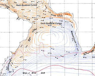
The Brazil Current is a warm water current that flows south along the Brazilian south coast to the mouth of the Río de la Plata.

A parent to the Florida Current, the Loop Current is a warm ocean current that flows northward between Cuba and the Yucatán Peninsula, moves north into the Gulf of Mexico, loops east and south before exiting to the east through the Florida Straits and joining the Gulf Stream. The Loop Current is an extension of the western boundary current of the North Atlantic subtropical gyre. Serving as the dominant circulation feature in the Eastern Gulf of Mexico, the Loop Currents transports between 23 and 27 sverdrups and reaches maximum flow speeds of from 1.5 to 1.8 meters/second.
The oceanic or limnological mixed layer is a layer in which active turbulence has homogenized some range of depths. The surface mixed layer is a layer where this turbulence is generated by winds, surface heat fluxes, or processes such as evaporation or sea ice formation which result in an increase in salinity. The atmospheric mixed layer is a zone having nearly constant potential temperature and specific humidity with height. The depth of the atmospheric mixed layer is known as the mixing height. Turbulence typically plays a role in the formation of fluid mixed layers.
The Tasman Outflow is a water pathway connecting water from the Pacific Ocean and the Indian Ocean. The existence of the outflow was published by scientists of the Australian CSIRO's Division of Marine and Atmospheric Research team in August 2007, interpreting salinity and temperature data captured from 1950 to 2002. The Tasman Outflow is seen as the missing link in the supergyre of the Southern Hemisphere and an important part of the thermohaline circulation.

The West Spitsbergen Current (WSC) is a warm, salty current that runs poleward just west of Spitsbergen,, in the Arctic Ocean. The WSC branches off the Norwegian Atlantic Current in the Norwegian Sea. The WSC is of importance because it drives warm and salty Atlantic Water into the interior Arctic. The warm and salty WSC flows north through the eastern side of Fram Strait, while the East Greenland Current (EGC) flows south through the western side of Fram Strait. The EGC is characterized by being very cold and low in salinity, but above all else it is a major exporter of Arctic sea ice. Thus, the EGC combined with the warm WSC makes the Fram Strait the northernmost ocean area having ice-free conditions throughout the year in all of the global ocean.

The Somali Current is a warm ocean boundary current that runs along the coast of Somalia and Oman in the Western Indian Ocean and is analogous to the Gulf Stream in the Atlantic Ocean. This current is heavily influenced by the monsoons and is the only major upwelling system that occurs on a western boundary of an ocean. The water that is upwelled by the current merges with another upwelling system, creating one of the most productive ecosystems in the ocean.
Retroflection is the movement of an ocean current that doubles back on itself.
North Pacific Intermediate Water (NPIW) is cold, moderately low salinity water mass that originates in the mixed water region (MWR) between the Kuroshio and Oyashio waters just east of Japan. Examination of NPIW at stations just east of the MWR indicates that the mixed waters in the MWR are the origin of the newest NPIW. The new NPIW ‘‘formed’’ in the MWR is a mixture of relatively fresh, recently ventilated Oyashio water coming from the subpolar gyre, and more saline, older Kuroshio water. The mixing process results in a salinity minimum and also in rejuvenation of the NPIW layer in the subtropical gyre due to the Oyashio input.

Mode water is defined as a particular type of water mass, which is nearly vertically homogeneous. Its vertical homogeneity is caused by the deep vertical convection in winter. The first term to describe this phenomenon is 18° water, which was used by Valentine Worthington to describe the isothermal layer in the northern Sargasso Sea cool to a temperature of about 18 °C each winter. Then Masuzawa introduced the subtropical mode water concept to describe the thick layer of temperature 16–18 °C in the northwestern North Pacific subtropical gyre, on the southern side of the Kuroshio Extension. The terminology mode water was extended to the thick near-surface layer north of the Subantarctic Front by McCartney, who identified and mapped the properties of the Subantarctic mode water (SAMW). After that, McCartney and Talley then applied the term subpolar mode water (SPMW) to the thick near-surface mixed layers in the North Atlantic’s subpolar gyre.
Low-latitude western boundary currents (LLWBC) are western boundary currents located between the subtropical gyres, within 20° of the equator. They are important for closing the tropical circulation driven by the equatorial zonal flow, and facilitate inter-ocean transport between the subtropical gyres. They occur in regions of negative (positive) wind stress curl in the southern (northern) hemisphere, and originate at the western bifurcation point of the South or North Equatorial Current. They are typically equatorward (cyclonic) as opposed to sub-tropical western boundary currents, which tend to be poleward (anticyclonic). Some well-known examples include the Mindanao Current (MC) and the East African Coastal Current (EACC).
The Agulhas Leakage is an inflow of anomalously warm and saline water from the Indian Ocean into the South Atlantic due to the limited latitudinal extent of the African continent compared to the southern extension of the subtropical super gyre in the Indian Ocean. The process occurs during the retroflection of the Agulhas Current via shedding of anticyclonic Agulhas Rings, cyclonic eddies and direct inflow. The leakage contributes to the Atlantic Meridional Overturning Circulation (AMOC) by supplying its upper limb, which has direct climate implications.

The North Brazil Current (NBC) retroflects north-eastwards and merges into the North Equatorial Counter Current (NECC). The retroflection occurs in a seasonal pattern when there is strong retroflection from late summer to early winter. There is weakened or no retroflection during other times of the year. Just like in the Agulhas Current, the retroflection also sheds some eddies that make their way to the Caribbean Sea through the Lesser Antilles.
References
- ↑ Árnault, S.; Bourles, B.; Gouriou, Y.; Chuchla, R. (1999). "Intercomparison of upper layer circulation of the western equatorial Atlantic Ocean: In situ and satellite data". Journal of Geophysical Research. 104 (C9): 21, 171–21, 94. doi:10.1029/1999JC900124.
- 1 2 Schott, Friedrich A.; Fischer, Juergen; Stramma, Lothar (1998). "Transports and pathways of the upper-layer circulation in the western tropical Atlantic" (PDF). Journal of Physical Oceanography. 28 (10): 1904–1929. doi:10.1175/1520-0485(1998)028<1904:TAPOTU>2.0.CO;2.
- 1 2 Bourles, B.; Gouriou, Y.; Chuchla, R. (1999). "On the circulation and upper layer of the western equatorial Atlantic". Journal of Geophysical Research. 104 (C9): 21151–21170. doi: 10.1029/1999JC900058 .
- ↑ Johns, W. E.; Lee, T.N.; Beardsley, R.C.; Candela, J.; Limeburner, R.; Castro, B. (1998). "Annual cycle and variability of the North Brazil Current". Journal of Physical Oceanography. 28 (1): 108–128. doi: 10.1175/1520-0485(1998)028<0103:ACAVOT>2.0.CO;2 .
- ↑ Bourles, B.; Molinari, R.L.; Johns, E.; Wilson, W.D. (1999). "Upper layer currents in the western tropical North Atlantic (1989-1991)". Journal of Geophysical Research. 104 (C1): 1361–1375. doi: 10.1029/1998JC900025 . S2CID 58924049.
- ↑ Stramma, Lothar; Fischer, Juergen; Reppin, Joerg (1995). "The North Brazil Undercurrent". Deep-Sea Research Part I. 42 (5): 733–795. doi:10.1016/0967-0637(95)00014-W.
- ↑ Fratatoni, David M.; Johns, William E.; Townsend, Tamara L. (1995). "Rings of the North Brazil Current: Their structure and behavior inferred from observations and a numerical simulation". Journal of Geophysical Research. 100 (C6): 10633–10654. doi:10.1029/95JC00925.