
The Antarctic Circumpolar Current (ACC) is an ocean current that flows clockwise from west to east around Antarctica. An alternative name for the ACC is the West Wind Drift. The ACC is the dominant circulation feature of the Southern Ocean and has a mean transport estimated at 100–150 Sverdrups, or possibly even higher, making it the largest ocean current. The current is circumpolar due to the lack of any landmass connecting with Antarctica and this keeps warm ocean waters away from Antarctica, enabling that continent to maintain its huge ice sheet.

North Atlantic Deep Water (NADW) is a deep water mass formed in the North Atlantic Ocean. Thermohaline circulation of the world's oceans involves the flow of warm surface waters from the southern hemisphere into the North Atlantic. Water flowing northward becomes modified through evaporation and mixing with other water masses, leading to increased salinity. When this water reaches the North Atlantic it cools and sinks through convection, due to its decreased temperature and increased salinity resulting in increased density. NADW is the outflow of this thick deep layer, which can be detected by its high salinity, high oxygen content, nutrient minima, high 14C/12C, and chlorofluorocarbons (CFCs).

The Weddell Sea is part of the Southern Ocean and contains the Weddell Gyre. Its land boundaries are defined by the bay formed from the coasts of Coats Land and the Antarctic Peninsula. The easternmost point is Cape Norvegia at Princess Martha Coast, Queen Maud Land. To the east of Cape Norvegia is the King Haakon VII Sea. Much of the southern part of the sea is covered by a permanent, massive ice shelf field, the Filchner-Ronne Ice Shelf.

The Drake Passage is the body of water between South America's Cape Horn, Chile, Argentina and the South Shetland Islands of Antarctica. It connects the southwestern part of the Atlantic Ocean with the southeastern part of the Pacific Ocean and extends into the Southern Ocean. The passage is named after the 16th-century English explorer and privateer Sir Francis Drake.

An ocean current is a continuous, directed movement of seawater generated by a number of forces acting upon the water, including wind, the Coriolis effect, breaking waves, cabbeling, and temperature and salinity differences. Depth contours, shoreline configurations, and interactions with other currents influence a current's direction and strength. Ocean currents are primarily horizontal water movements.

Thermohaline circulation (THC) is a part of the large-scale ocean circulation that is driven by global density gradients created by surface heat and freshwater fluxes. The adjective thermohaline derives from thermo- referring to temperature and -haline referring to salt content, factors which together determine the density of sea water. Wind-driven surface currents travel polewards from the equatorial Atlantic Ocean, cooling en route, and eventually sinking at high latitudes. This dense water then flows into the ocean basins. While the bulk of it upwells in the Southern Ocean, the oldest waters upwell in the North Pacific. Extensive mixing therefore takes place between the ocean basins, reducing differences between them and making the Earth's oceans a global system. The water in these circuits transport both energy and mass around the globe. As such, the state of the circulation has a large impact on the climate of the Earth.

The Agulhas Current is the western boundary current of the southwest Indian Ocean. It flows south along the east coast of Africa from 27°S to 40°S. It is narrow, swift and strong. It is suggested that it is the largest western boundary current in the world ocean, with an estimated net transport of 70 sverdrups, as western boundary currents at comparable latitudes transport less — Brazil Current, Gulf Stream, Kuroshio.

The Indonesian Throughflow is an ocean current with importance for global climate as is the low-latitude movement of warm, relative freshwater from the north Pacific to the Indian Ocean. It thus serves as a main upper branch of the global heat/salt conveyor belt.

In oceanography, a gyre is any large system of circulating ocean surface currents, particularly those involved with large wind movements. Gyres are caused by the Coriolis effect; planetary vorticity, horizontal friction and vertical friction determine the circulatory patterns from the wind stress curl (torque).
The East Australian Current (EAC) is a warm, southward, western boundary current that is formed from the South Equatorial Current (SEC) crossing the Coral Sea and reaching the eastern coast of Australia. At around 15° S near the Australian coast the SEC divides forming the southward flow of the EAC. It is the largest ocean current close to the shores of Australia.

The sub-Antarctic zone is a region in the Southern Hemisphere, located immediately north of the Antarctic region. This translates roughly to a latitude of between 46° and 60° south of the Equator. The subantarctic region includes many islands in the southern parts of the Atlantic, Indian, and Pacific oceans, especially those situated north of the Antarctic Convergence. Sub-Antarctic glaciers are, by definition, located on islands within the sub-Antarctic region. All glaciers located on the continent of Antarctica are by definition considered to be Antarctic glaciers.

The Weddell Gyre is one of the two gyres that exist within the Southern Ocean. The gyre is formed by interactions between the Antarctic Circumpolar Current (ACC) and the Antarctic Continental Shelf. The gyre is located in the Weddell Sea, and rotates clockwise. South of the ACC and spreading northeast from the Antarctic Peninsula, the gyre is an extended large cyclone. Where the northeastern end ends at 30°E, which is marked by the southward turn of the ACC, the northern part of the gyre spreads over the Southern Scotia Sea and goes northward to the South Sandwich Arc. Axis of the gyre is over the southern flanks of the South Scotia, America-Antarctic, and Southwest Indian Ridges. In the southern part of the gyre, the westward return flow is about 66 sverdrup (Sv), while in the northern rim current, there is an eastward flow of 61 Sv.

The Beaufort Gyre is one of the two major ocean currents in the Arctic Ocean. It is roughly located north of the Alaskan and Canadian coast. In the past, Arctic sea-ice would circulate in the Beaufort gyre up to several years, leading to the formation of very thick multi-year sea-ice. Due to warming temperatures in the Arctic, the gyre has lost an extensive amount of ice, practically turning what used to be a nursery for sea-ice to mature and grow into the thickest and oldest ice of the Arctic Ocean into a "graveyard" for older ice.
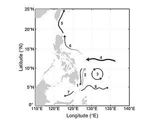
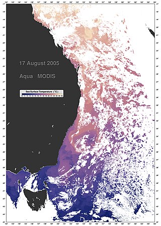
The Mindanao Current (MC) is a southward current in the western Pacific Ocean that transports mass and freshwater between ocean basins. It is a low-latitude western boundary current that follows the eastern coast of the Philippine island group and its namesake, Mindanao. The MC forms from the North Equatorial Current (NEC) that flows from east to west between 10-20°N. As it travels west, the NEC reaches its western limit: the coast of the Philippines. Once it encounters shallower waters near land, it “splits” into two branches: one moves northward and becomes the Kuroshio current and one moves southward and becomes the Mindanao Current. The process of splitting is called a bifurcation.
North Pacific Intermediate Water (NPIW) is cold, moderately low salinity water mass that originates in the mixed water region (MWR) between the Kuroshio and Oyashio waters just east of Japan. Examination of NPIW at stations just east of the MWR indicates that the mixed waters in the MWR are the origin of the newest NPIW. The new NPIW ‘‘formed’’ in the MWR is a mixture of relatively fresh, recently ventilated Oyashio water coming from the subpolar gyre, and more saline, older Kuroshio water. The mixing process results in a salinity minimum and also in rejuvenation of the NPIW layer in the subtropical gyre due to the Oyashio input.

Mode water is defined as a particular type of water mass, which is nearly vertically homogeneous. Its vertical homogeneity is caused by the deep vertical convection in winter. The first term to describe this phenomenon is 18° water, which was used by Valentine Worthington to describe the isothermal layer in the northern Sargasso Sea cool to a temperature of about 18 °C each winter. Then Masuzawa introduced the subtropical mode water concept to describe the thick layer of temperature 16–18 °C in the northwestern North Pacific subtropical gyre, on the southern side of the Kuroshio Extension. The terminology mode water was extended to the thick near-surface layer north of the Subantarctic Front by McCartney, who identified and mapped the properties of the Subantarctic mode water (SAMW). After that, McCartney and Talley then applied the term subpolar mode water (SPMW) to the thick near-surface mixed layers in the North Atlantic’s subpolar gyre.
A Wind generated current is a flow in a body of water that is generated by wind friction on its surface. Wind can generate surface currents on water bodies of any size. The depth and strength of the current depend on the wind strength and duration, and on friction and viscosity losses, but are limited to about 400 m depth by the mechanism, and to lesser depths where the water is shallower. The direction of flow is influenced by the Coriolis effect, and is offset to the right of the wind direction in the Northern Hemisphere, and to the left in the Southern Hemisphere. A wind current can induce secondary water flow in the form of upwelling and downwelling, geostrophic flow, and western boundary currents.
Low-latitude western boundary currents (LLWBC) are western boundary currents located between the subtropical gyres, within 20° of the equator. They are important for closing the tropical circulation driven by the equatorial zonal flow, and facilitate inter-ocean transport between the subtropical gyres. They occur in regions of negative (positive) wind stress curl in the southern (northern) hemisphere, and originate at the western bifurcation point of the South or North Equatorial Current. They are typically equatorward (cyclonic) as opposed to sub-tropical western boundary currents, which tend to be poleward (anticyclonic). Some well-known examples include the Mindanao Current (MC) and the East African Coastal Current (EACC).
The Agulhas Leakage is an inflow of anomalously warm and saline water from the Indian Ocean into the South Atlantic due to the limited latitudinal extent of the African continent compared to the southern extension of the subtropical super gyre in the Indian Ocean. The process occurs during the retroflection of the Agulhas Current via shedding of anticyclonic Agulhas Rings, cyclonic eddies and direct inflow. The leakage contributes to the Atlantic Meridional Overturning Circulation (AMOC) by supplying its upper limb, which has direct climate implications.
Oceanic freshwater fluxes are defined as the transport of non saline water between the oceans and the other components of the Earth's system. These fluxes have an impact on the local ocean properties, as well as on the large scale circulation patterns.

