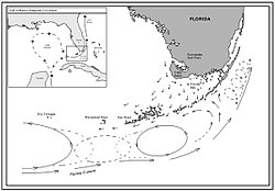
The Drake Passage is the body of water between South America's Cape Horn, Chile, Argentina, and the South Shetland Islands of Antarctica. It connects the southwestern part of the Atlantic Ocean with the southeastern part of the Pacific Ocean and extends into the Southern Ocean. The passage is named after the 16th-century English explorer and privateer Sir Francis Drake.

An ocean current is a continuous, directed movement of seawater generated by a number of forces acting upon the water, including wind, the Coriolis effect, breaking waves, cabbeling, and temperature and salinity differences. Depth contours, shoreline configurations, and interactions with other currents influence a current's direction and strength. Ocean currents are primarily horizontal water movements.

The surface layer is the layer of a turbulent fluid most affected by interaction with a solid surface or the surface separating a gas and a liquid where the characteristics of the turbulence depend on distance from the interface. Surface layers are characterized by large normal gradients of tangential velocity and large concentration gradients of any substances transported to or from the interface.
Warren White is a professor emeritus, and a former Research Oceanographer at the Marine Biological Research Division at Scripps Institution of Oceanography at UC San Diego.

The Pacific decadal oscillation (PDO) is a robust, recurring pattern of ocean-atmosphere climate variability centered over the mid-latitude Pacific basin. The PDO is detected as warm or cool surface waters in the Pacific Ocean, north of 20°N. Over the past century, the amplitude of this climate pattern has varied irregularly at interannual-to-interdecadal time scales. There is evidence of reversals in the prevailing polarity of the oscillation occurring around 1925, 1947, and 1977; the last two reversals corresponded with dramatic shifts in salmon production regimes in the North Pacific Ocean. This climate pattern also affects coastal sea and continental surface air temperatures from Alaska to California.

The North Equatorial Current (NEC) is a westward wind-driven current mostly located near the equator, but the location varies from different oceans. The NEC in the Pacific and the Atlantic is about 5°-20°N, while the NEC in the Indian Ocean is very close to the equator. It ranges from the sea surface down to 400 m in the western Pacific.
The Equatorial Counter Current is an eastward flowing, wind-driven current which extends to depths of 100–150 metres (330–490 ft) in the Atlantic, Indian, and Pacific Oceans. More often called the North Equatorial Countercurrent (NECC), this current flows west-to-east at about 3-10°N in the Atlantic, Indian Ocean and Pacific basins, between the North Equatorial Current (NEC) and the South Equatorial Current (SEC). The NECC is not to be confused with the Equatorial Undercurrent (EUC) that flows eastward along the equator at depths around 200 metres (660 ft) in the western Pacific rising to 100 metres (330 ft) in the eastern Pacific.

The Norwegian Current is one of two dominant arctic inflows of water. It can be traced from near Shetland, north of Scotland, otherwise from the eastern North Sea at depths of up to 100 metres. It finally passes the opening into the Barents Sea, a large outcrop of the Arctic Ocean. Compared to its partial source the North Atlantic Current it is colder and less salty; the other sources are the less saline North and Baltic seas and the Norwegian fjords and rivers. It is considerably warmer and saltier than the Arctic Ocean, which is freshened by precipitation and ice in and around it. Winter temperatures in the flow are typically between 2 and 5 °C — the co-parent North Atlantic flow, a heat remnant of its Gulf Stream chief contributor, exceeds 6 °C.
The North Brazil Current (NBC) is a warm water ocean current that is part of the southwestern North Atlantic Gyre. It begins when the westward moving Atlantic South Equatorial Current splits in half and flows northwestward, following the coastline of north Brazil. It ends at the border of Brazil and Guiana, where it is renamed the Guiana Current. It is predominantly a salt water current, but it does help transport fresh water from the Amazon River northward.

In fluid dynamics, an eddy is the swirling of a fluid and the reverse current created when the fluid is in a turbulent flow regime. The moving fluid creates a space devoid of downstream-flowing fluid on the downstream side of the object. Fluid behind the obstacle flows into the void creating a swirl of fluid on each edge of the obstacle, followed by a short reverse flow of fluid behind the obstacle flowing upstream, toward the back of the obstacle. This phenomenon is naturally observed behind large emergent rocks in swift-flowing rivers.
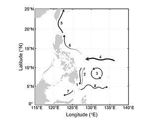
The Mindanao Current (MC) is a southward current in the western Pacific Ocean that transports mass and freshwater between ocean basins. It is a low-latitude western boundary current that follows the eastern coast of the Philippine island group and its namesake, Mindanao. The MC forms from the North Equatorial Current (NEC) that flows from east to west between 10-20°N. As it travels west, the NEC reaches its western limit: the coast of the Philippines. Once it encounters shallower waters near land, it “splits” into two branches: one moves northward and becomes the Kuroshio current and one moves southward and becomes the Mindanao Current. The process of splitting is called a bifurcation.

The Somali Current is a cold ocean boundary current that runs along the coast of Somalia and Oman in the Western Indian Ocean and is analogous to the Gulf Stream in the Atlantic Ocean. This current is heavily influenced by the monsoons and is the only major upwelling system that occurs on a western boundary of an ocean. The water that is upwelled by the current merges with another upwelling system, creating one of the most productive ecosystems in the ocean.
Adrian Edmund Gill FRS was an Australian meteorologist and oceanographer best known for his textbook Atmosphere-Ocean Dynamics. Gill was born in Melbourne, Australia, and worked at Cambridge, serving as Senior Research Fellow from 1963 to 1984. His father was Edmund Gill, geologist, palaeontologist and curator at the National Museum of Victoria.
North Pacific Intermediate Water (NPIW) is cold, moderately low salinity water mass that originates in the mixed water region (MWR) between the Kuroshio and Oyashio waters just east of Japan. Examination of NPIW at stations just east of the MWR indicates that the mixed waters in the MWR are the origin of the newest NPIW. The new NPIW ‘‘formed’’ in the MWR is a mixture of relatively fresh, recently ventilated Oyashio water coming from the subpolar gyre, and more saline, older Kuroshio water. The mixing process results in a salinity minimum and also in rejuvenation of the NPIW layer in the subtropical gyre due to the Oyashio input.

The Kuroshio Current is a northward flowing Western Boundary Current (WBC) in the Pacific Ocean. It is a bifurcation arm of the North Equatorial Current and consists of northwestern Pacific Ocean water. The other arm is the southward flowing Mindanao Current. The Kuroshio Current flows along the eastern Philippine coast, up to 13.7 Sv... of it leaking into the Luzon Strait - the gap between the Philippines and Taiwan - before continuing along the Japanese coast. Some of the leaked water manages to intrude into the South China Sea (SCS). This affects the heat and salt budgets and circulation and eddy generation mechanisms in the SCS. There are various theories about possible intrusion paths and what mechanisms initiate them.
Ring shedding is a phenomenon in ocean currents where circle or ring-shaped eddies separate from the current. The rings are independent water current systems that can persist for several months and occur in most ocean basins. The separated rings can have both warm or cold cores and play a role in the thermohaline circulation, interocean mixing, and nutrient supply for algae and bacteria. The physical processes behind ring shedding are not fully understood yet and are thus an active subject of research.
Sarah Gille is a physical oceanographer at Scripps Institution of Oceanography known for her research on the role of the Southern Ocean in the global climate system.
Phyllis Jean Stabeno is a physical oceanographer known for her research on the movement of water in polar regions. She has led award-winning research projects in the Arctic and was noted for a distinguished scientific career by the National Oceanic and Atmospheric Administration.
LuAnn Thompson is the Walters Endowed Professor at the University of Washington. She is known for her work in modeling the movement of heat and chemicals via ocean currents.

Irminger Rings (IRs) are mesoscale ocean eddies that are formed off the West coast of Greenland and travel southwestwards through the Labrador Sea. Most IRs are anti-cyclonic. There is considerable interest in researching IRs, because they have been hypothesized to influence deep convection in the Labrador sea, and therefore the formation of deep water.