Eastover, North Carolina

Last updated

Eastover, North Carolina
Eastover Community Center.jpg
Eastover Community Center
Eastover, NC Town Seal.png
Motto(s): 
"Remembering Our Heritage, Creating Our Future"
Cumberland County North Carolina incorporated and unincorporated areas Eastover highlighted.svg
Location in Cumberland County and the state of North Carolina.
Coordinates: 35°06′29″N78°46′46″W / 35.10806°N 78.77944°W / 35.10806; -78.77944
Country United States
State North Carolina
County Cumberland
Incorporated2007
Government
  MayorCharles McLaurin
Area
[1]
  Total11.34 sq mi (29.36 km2)
  Land11.33 sq mi (29.34 km2)
  Water0.01 sq mi (0.02 km2)
Elevation
[2]
141 ft (43 m)
Population
 (2020)
  Total3,656
  Density322.74/sq mi (124.61/km2)
Time zone UTC-5 (Eastern (EST))
  Summer (DST) UTC-4 (EDT)
ZIP code
28312
Area codes 910, 472
FIPS code 37-19740 [3]
GNIS feature ID2402438 [2]
Website www.eastovernc.com

Eastover is a town in Cumberland County, North Carolina, United States. The population was 3,656 at the 2020 census. It was incorporated on July 25, 2007. [4]

Contents

History

The Robert Williams House was listed on the National Register of Historic Places in 1983. [5]

Geography

Eastover is located northeast of the center of Cumberland County. It is 7 miles (11 km) northeast of downtown Fayetteville.

U.S. Route 301 passes through the center of the town as Dunn Road. Interstate 95 runs parallel to US 301 on the east side of town, with access from Exits 55, 56, and 58. I-95 leads northeast 82 miles (132 km) to the Rocky Mount area and southwest 91 miles (146 km) to Florence, South Carolina. Interstate 295 leaves I-95 at Exit 58 and heads west as a northern bypass of Fayetteville, while the southern terminus of U.S. Route 13 is also at Exit 58, with the highway leading northeast 50 miles (80 km) to Goldsboro.

According to the United States Census Bureau, Eastover has a total area of 11.4 square miles (29.4 km2), of which 0.01 square miles (0.02 km2), or 0.08%, is water. [6]

Demographics

Historical population
CensusPop.Note
1980 1,075
1990 1,24315.6%
2000 1,37610.7%
2010 3,628163.7%
2020 3,6560.8%
U.S. Decennial Census [7]

2020 census

Eastover racial composition [8]
RaceNumberPercentage
White (non-Hispanic)2,54869.69%
Black or African American (non-Hispanic)68618.76%
Native American 541.48%
Asian 330.9%
Pacific Islander 40.11%
Other/Mixed 1764.81%
Hispanic or Latino 1554.24%

As of the 2020 United States census, there were 3,656 people, 1,346 households, and 926 families residing in the town.

2010 census

As of the census [3] of 2010, there were 3,628 people, 1,476 households, and 1,042 families residing in the town. The population density was 320 inhabitants per square mile (120/km2). There were 1,637 housing units at an average density of 144.5 units/sq mi (55.8/km2). The racial makeup of the CDP was 74.9% White, 19.2% African American, 1.9% Native American, 0.9% Asian, 0.1% Native Hawaiian or Other Pacific Islander, 1.2% some other race, and 1.8% from two or more races. Hispanic or Latino of any race were 3.0% of the population. [9]

There were 1,476 households, out of which 29.9% had children under the age of 18 living with them, 53.4% were headed by married couples living together, 13.3% had a female householder with no husband present, and 29.4% were non-families. 24.7% of all households were made up of individuals, and 10.4% were someone living alone who was 65 years of age or older. The average household size was 2.40, and the average family size was 2.86. [9]

In the CDP the population was spread out, with 21.1% under the age of 18, 6.4% from 18 to 24, 22.7% from 25 to 44, 31.6% from 45 to 64, and 18.4% who were 65 years of age or older. The median age was 44.9 years. For every 100 females, there were 91.9 males. For every 100 females age 18 and over, there were 88.2 males. [9]

For the period 2009–13, the estimated median annual income for a household in the CDP was $42,639, and the median income for a family was $62,461. Male full-time workers had a median income of $41,691 versus $46,128 for females. The per capita income for the CDP was $28,108. About 10.2% of families and 8.8% of the total population were below the poverty line, including 7.3% of those under age 18 and 3.8% of those age 65 or over. [10]

Related Research Articles

<span class="mw-page-title-main">Icard, North Carolina</span> Census-designated place in North Carolina, United States

Icard is a census-designated place (CDP) in Burke County, North Carolina, United States. The population was 2,664 at the 2010 census. It is part of the Hickory–Lenoir–Morganton Metropolitan Statistical Area.

<span class="mw-page-title-main">Mountain View, North Carolina</span> Census-designated place in North Carolina, United States

Mountain View is a census-designated place (CDP) in Catawba County, North Carolina, United States. The population was 3,552 at the 2010 census. It is part of the Hickory–Lenoir–Morganton Metropolitan Statistical Area.

Brices Creek is an unincorporated area and census-designated place (CDP) in Craven County, North Carolina, United States. The population was 3,073 at the 2010 census. It is part of the New Bern, North Carolina Metropolitan Statistical Area.

<span class="mw-page-title-main">Godwin, North Carolina</span> Town in North Carolina, United States

Godwin is a town in Cumberland County, North Carolina, United States. The population was 139 at the 2010 census.

<span class="mw-page-title-main">Hope Mills, North Carolina</span> Town in North Carolina, United States

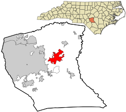
Hope Mills is a town in Cumberland County, North Carolina, United States. Its population was 15,176 at the 2010 census.

<span class="mw-page-title-main">Linden, North Carolina</span> Town in North Carolina, United States

Linden is a town in Cumberland County, North Carolina, United States. The population was 130 at the 2010 census, the mayor is Frances Collier.

<span class="mw-page-title-main">Spring Lake, North Carolina</span> Town in North Carolina, United States

Spring Lake is a town in Cumberland County, North Carolina, United States. The 2010 census recorded the population at 11,964 people, with an estimated population in 2019 of 12,005.

<span class="mw-page-title-main">Stedman, North Carolina</span> Town in North Carolina, United States

Stedman is a town in Cumberland County, North Carolina, United States. The population was 1,028 at the 2010 census. It is named for Civil War Major Charles Manly Stedman.

<span class="mw-page-title-main">Vander, North Carolina</span> Census-designated place in North Carolina, United States

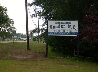
Vander is an unincorporated community and census-designated place (CDP) in Cumberland County, North Carolina, United States. The population was 1,388 at the 2020 census.

<span class="mw-page-title-main">Wade, North Carolina</span> Town in North Carolina, United States

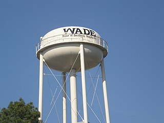
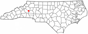
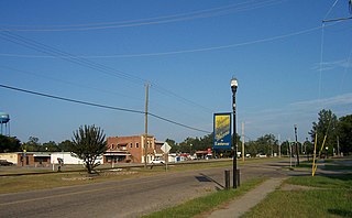
Wade is a town in Cumberland County, North Carolina, United States. The population was 556 at the 2010 census.

<span class="mw-page-title-main">Gorman, North Carolina</span> Census-designated place in North Carolina, United States

Gorman is a census-designated place (CDP) in Durham County, North Carolina, United States. The population was 1,011 at the 2010 census.

<span class="mw-page-title-main">McLeansville, North Carolina</span> Census-designated place in North Carolina, United States

McLeansville is an unincorporated community and census-designated place (CDP) in Guilford County, North Carolina, United States. The population was 1,021 at the 2010 census.

<span class="mw-page-title-main">East Flat Rock, North Carolina</span> Census-designated place in North Carolina, United States

East Flat Rock is an unincorporated area and census-designated place (CDP) in Henderson County, North Carolina, United States. The population was 4,995 at the 2010 census, up from 4,151 at the 2000 census. It is part of the Asheville Metropolitan Statistical Area.

<span class="mw-page-title-main">Rockfish, North Carolina</span> Census-designated place in North Carolina, United States

Rockfish is a census-designated place (CDP) in Hoke County, North Carolina, United States. The population was 3,298 at the 2010 census, up from 2,353 at the 2000 census.

<span class="mw-page-title-main">Silver City, North Carolina</span> Census-designated place in North Carolina, United States

Silver City is an unincorporated area and census-designated place (CDP) in Hoke County, North Carolina in the United States. The population was 882 at the 2010 census, down from 1,146 at the 2000 census.

<span class="mw-page-title-main">Eureka Mill, South Carolina</span> Census-designated place in South Carolina, United States

Eureka Mill is a census-designated place (CDP) in Chester County, South Carolina, United States. The population was 1,476 at the 2010 census, down from 1,737 at the 2000 census.

<span class="mw-page-title-main">Gantt, South Carolina</span> Census-designated place in South Carolina, United States

Gantt is a census-designated place (CDP) in Greenville County, South Carolina, United States. The population was 14,229 at the 2010 census. It is part of the Greenville–Mauldin–Easley Metropolitan Statistical Area and a suburb of the city of Greenville.

<span class="mw-page-title-main">Eastover, South Carolina</span> Town in South Carolina, United States

Eastover is a town in Richland County, South Carolina, United States. The population was 813 at the 2010 census, down from 830 in 2000. It is part of the Columbia, South Carolina, Metropolitan Statistical Area.

<span class="mw-page-title-main">Falcon, North Carolina</span> Town in North Carolina, United States

Falcon is a town in Cumberland and Sampson counties in the U.S. state of North Carolina. The population was 258 at the 2010 census.

<span class="mw-page-title-main">Piedmont, South Carolina</span> CDP in South Carolina, United States

Piedmont is a census-designated place (CDP) along the Saluda River in Anderson and Greenville counties in the U.S. state of South Carolina. The population was 5,411 at the 2020 census.

References

  1. "ArcGIS REST Services Directory". United States Census Bureau. Retrieved September 20, 2022.
  2. 1 2 U.S. Geological Survey Geographic Names Information System: Eastover, North Carolina
  3. 1 2 "U.S. Census website". United States Census Bureau . Retrieved January 31, 2008.
  4. Andrew Barksdale. "Eastover: A town is born in Cumberland County". Fayetteville Observer. Archived from the original on October 22, 2007. Retrieved July 27, 2007.
  5. "National Register Information System". National Register of Historic Places . National Park Service. July 9, 2010.
  6. "Geographic Identifiers: 2010 Demographic Profile Data (G001): Eastover town, North Carolina". U.S. Census Bureau, American Factfinder. Archived from the original on February 12, 2020. Retrieved January 5, 2015.
  7. "Census of Population and Housing". Census.gov. Retrieved June 4, 2015.
  8. "Explore Census Data". data.census.gov. Retrieved December 23, 2021.
  9. 1 2 3 "Profile of General Population and Housing Characteristics: 2010 Demographic Profile Data (DP-1): Eastover town, North Carolina". U.S. Census Bureau, American Factfinder. Archived from the original on January 5, 2015. Retrieved January 5, 2015.
  10. "Selected Economic Characteristics: 2009-2013 American Community Survey 5-Year Estimates (DP03): Eastover town, North Carolina". U.S. Census Bureau, American Factfinder. Archived from the original on January 5, 2015. Retrieved January 5, 2015.