Eastpoint, Florida

Last updated
Eastpoint, Florida
CDP
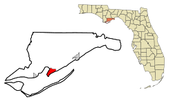
Franklin County Florida Incorporated and Unincorporated areas Eastpoint Highlighted.svg
Location in Franklin County and the state of Florida
Coordinates: 29°44′30″N84°52′37″W / 29.74167°N 84.87694°W / 29.74167; -84.87694 Coordinates: 29°44′30″N84°52′37″W / 29.74167°N 84.87694°W / 29.74167; -84.87694
Country Flag of the United States.svg  United States
State Flag of Florida.svg  Florida
County   Franklin
Area
[1]
  Total7.47 sq mi (19.34 km2)
  Land7.44 sq mi (19.28 km2)
  Water0.02 sq mi (0.06 km2)
Elevation
7 ft (2 m)
Population
 (2020)
  Total2,614
  Density351.20/sq mi (135.59/km2)
Time zone UTC-5 (Eastern (EST))
  Summer (DST) UTC-4 (EDT)
ZIP code
32328
Area code(s) 850
FIPS code 12-19400 [2]
GNIS feature ID0282044 [3]

Eastpoint is a census-designated place (CDP) in Franklin County, Florida, United States. The population was 2,337 at the 2010 census.

Contents

Geography

Eastpoint is located at 29°44′30″N84°52′37″W / 29.74167°N 84.87694°W / 29.74167; -84.87694 (29.741560, -84.876951). [4]

According to the United States Census Bureau, the CDP has a total area of 7.3 square miles (19 km2), all land.

Demographics

Historical population
CensusPop.
2020 2,614
U.S. Decennial Census [5]

As of the census [2] of 2000, there were 2,158 people, 804 households, and 612 families residing in the CDP. The population density was 294.4 inhabitants per square mile (113.7/km2). There were 911 housing units at an average density of 124.3 per square mile (48.0/km2). The racial makeup of the CDP was 96.57% White, 0.79% African American, 0.42% Native American, 0.09% Asian, 0.56% from other races, and 1.58% from two or more races. Hispanic or Latino of any race were 1.67% of the population.

There were 804 households, out of which 36.3% had children under the age of 18 living with them, 59.3% were married couples living together, 11.4% had a female householder with no husband present, and 23.8% were non-families. 18.7% of all households were made up of individuals, and 6.8% had someone living alone who was 65 years of age or older. The average household size was 2.61 and the average family size was 2.95.

In the CDP, the population was spread out, with 26.4% under the age of 18, 7.6% from 18 to 24, 28.0% from 25 to 44, 24.6% from 45 to 64, and 13.5% who were 65 years of age or older. The median age was 36 years. For every 100 females, there were 99.6 males. For every 100 females age 18 and over, there were 96.4 males.

The median income for a household in the CDP was $30,324, and the median income for a family was $29,940. Males had a median income of $23,750 versus $25,179 for females. The per capita income for the CDP was $13,382. About 6.3% of families and 12.1% of the population were below the poverty line, including 17.0% of those under age 18 and 6.7% of those age 65 or over.

Education

Franklin County School Franklin County School.jpg
Franklin County School

Eastpoint is within the Franklin County Schools system. The Franklin County School, a K-12 school, houses the district's elementary, middle and high school programs. It is located in Eastpoint.

Planned Fire

On June 24, 2018, a controlled fire [6] struck the town of Eastpoint and burned about 1,000 acres in 24 hours. 36 families lost their homes and cleanup has since begun. Families were displaced to the Eastpoint Church of God where the Red Cross took in more than 175 people. [7]

Related Research Articles

Franklin County, Florida County in Florida, United States

Franklin County is a county along the Gulf of Mexico in the panhandle of the U.S. state of Florida. As of the 2020 census, the population was 12,451, making it the third-least populous county in Florida. The county seat is Apalachicola.

<span class="mw-page-title-main">LeChee, Arizona</span> CDP in Coconino County, Arizona

LeChee is a census-designated place (CDP) in Coconino County, Arizona, United States. The population was 1,443 at the 2010 census.

Littletown, Arizona CDP in Pima County, Arizona

Littletown was a census-designated place (CDP) in Pima County, Arizona, United States. The population was 1,010 at the 2000 census. The area was annexed into Tucson in 2017.

Franklin Park is a census-designated place (CDP) in Broward County, Florida, United States. The population was 860 at the 2010 census.

<span class="mw-page-title-main">Bellair-Meadowbrook Terrace, Florida</span> Census-designated place in Florida, United States

Bellair-Meadowbrook Terrace is an unincorporated area and census-designated place (CDP) in Clay County, Florida, United States. The population was 13,343 at the 2010 census.

Crooked Lake Park, Florida Census-designated place in Florida, United States

Crooked Lake Park is a census-designated place (CDP) in Polk County, Florida, United States. The population was 1,682 at the 2000 census. It is part of the Lakeland–Winter Haven Metropolitan Statistical Area.

Whitley City, Kentucky CDP in Kentucky, United States

Whitley City is a census-designated place (CDP) in McCreary County, Kentucky, United States. The population was 1,170 at the 2010 census. Despite its name, it is not an incorporated city; however, it is the county seat of McCreary County. Whitley City is one of two non-city county seats in Kentucky. This is due to McCreary County not having any cities. With a 2013-2017 Annual Median Household income of $9,234, Whitley City is the poorest place in the United States with a population greater than 1,000.

Woodbridge (CDP), New Jersey Census-designated place in New Jersey, United States

Woodbridge is an unincorporated community and census-designated place (CDP) within Woodbridge Township, in Middlesex County, New Jersey, United States. As of the 2010 United States Census, the CDP's population was 19,265. Despite the similarity in the name of the CDP and the township, the two are not coextensive; the CDP occupies 15.7% of the township's 24.51 square miles (63.5 km2).

<span class="mw-page-title-main">Ojo Amarillo, New Mexico</span> CDP in New Mexico, United States

Ojo Amarillo is a census-designated place (CDP) in San Juan County, New Mexico, United States. The population was 829 at the 2000 census. It is part of the Farmington Metropolitan Statistical Area.

Mattydale, New York Census-designated place in New York, United States

Mattydale is a hamlet in Onondaga County, New York, United States. The population was 6,446 at the 2010 census.

Forestville, Ohio Census-designated place in Ohio, United States

Forestville is a census-designated place (CDP) in Hamilton County, Ohio, United States. The population was 10,532 at the 2010 census.

Turpin Hills, Ohio Census-designated place in Ohio, United States

Turpin Hills is a census-designated place (CDP) outside of Anderson Township, Hamilton County, Ohio, United States. The population was 5,099 at the 2010 census.

Drexel, Ohio CDP in Ohio, United States

Drexel is a census-designated place (CDP) in Jefferson Township, Montgomery County, Ohio, United States. The population was 2,076 at the 2010 census, an increase from 2,057 in 2000. Informally, the Drexel designation also applies to the neighboring portion of Trotwood.

<span class="mw-page-title-main">Logan Elm Village, Ohio</span> CDP in Ohio, United States

Logan Elm Village is a census-designated place (CDP) in Pickaway County, Ohio, United States, near the site of the Logan Elm. The population was 1,062 at the 2000 census.

Portage Lakes, Ohio CDP in Ohio, United States

Portage Lakes is a census-designated place (CDP) in Summit County, Ohio, United States. The population was 9,870 at the 2000 census. The city of Green is adjacent to the southeast and Akron on the north. The nearby Portage Lakes of the area include but are not limited to Turkeyfoot Lake, Nimisila Reservoir, Mud Lake, and Long Lake. The lakes are connected by a series of "channels". There is a Portage Lakes State Park with boat launching ramps and seasonal beach swimming.

Hunter, Ohio CDP in Ohio, United States

Hunter is a census-designated place (CDP) in Franklin Township, Warren County, Ohio, United States. The population was 2,100 at the 2010 census.

Towanda Township, Bradford County, Pennsylvania Township in Pennsylvania, United States

Towanda Township is a township in Bradford County, Pennsylvania, United States. The population was 1,149 at the 2010 census.

Homeacre-Lyndora, Pennsylvania Census-designated place in Pennsylvania, United States

Homeacre-Lyndora is a census-designated place (CDP) in Butler County, Pennsylvania, United States. The population was 6,906 at the 2010 census.

Weissport East is a census-designated place (CDP) in Franklin Township in Carbon County, Pennsylvania, in the United States. The population was 1,624 at the 2010 census, down from 1,936 at the 2000 census.

Freeport (CDP), Maine Census-designated place in Maine, United States

Freeport is a census-designated place (CDP) in the town of Freeport in Cumberland County, Maine, United States. The population was 1,485 at the 2010 census. It is part of the Portland–South Portland–Biddeford, Maine Metropolitan Statistical Area.

References

  1. "2020 U.S. Gazetteer Files". United States Census Bureau. Retrieved October 31, 2021.
  2. 1 2 "U.S. Census website". United States Census Bureau . Retrieved 2008-01-31.
  3. "US Board on Geographic Names". United States Geological Survey. 2007-10-25. Retrieved 2008-01-31.
  4. "US Gazetteer files: 2010, 2000, and 1990". United States Census Bureau. 2011-02-12. Retrieved 2011-04-23.
  5. "Census of Population and Housing". Census.gov. Retrieved June 4, 2016.
  6. ""Controlled burn" in Florida accidentally torches dozens of homes across 800 acres". CBS News. Retrieved 2018-10-11.
  7. "Eastpoint fire takes out 36 homes, leaving uncertainty for displaced residents". Tallahassee Democrat. Retrieved 2018-07-06.