Eccup

Last updated

Old Village Hall Eccup 2016.jpg
Old Village Hall, Eccup
West Yorkshire UK location map.svg
Red pog.svg
Eccup
Location within West Yorkshire
OS grid reference SE2842
Civil parish
Metropolitan borough
Metropolitan county
Region
Country England
Sovereign state United Kingdom
Police West Yorkshire
Fire West Yorkshire
Ambulance Yorkshire
UK Parliament
List of places
UK
England
Yorkshire
53°52′34″N1°33′54″W / 53.876°N 1.565°W / 53.876; -1.565

Eccup is a village in the parish of Alwoodley and north of the City of Leeds, West Yorkshire, England. It is just north of Alwoodley and east of Bramhope and Golden Acre Park. Eccup is at the north-west edge of Eccup Reservoir. On 1 April 1926 Eccup became a civil parish, being formed from part of Adel cum Eccup, on 1 April 1928 the parish was abolished and merged with Leeds. [1]

Contents

Etymology

The place-name Eccup is first attested in the Domesday Book of 1086 as Echope. It is thought to derive from an Old English personal name Ecca + hōp 'enclosed land amid unpromising land; a small, enclosed valley'. It would therefore mean something like 'Ecca's patch of good land'. [2] The name is referred to as Ecop in the Coucher Book of Kirkstall Abbey. [3] From the sixteenth century the area up to the River Wharfe was known as Adel cum Eccup. [4] Adel is about 2 miles south-west of Eccup.

Burden Head Farm, just to the north of the village, is also first attested in the Domesday book, as Burgedurun and Burgheduru’. It is thought to come from the Old English words burg ('fortified place') and dūn; thus it once meant 'hill of the fortification'. [5]

Geography

Kelly's Directory of the West Riding of Yorkshire (1881) refers to a Methodist (Wesleyan) chapel in Eccup. [6]

Use in Emmerdale

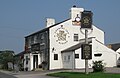
Eccup and The New Inn public house at the north of the village are location settings for the soap Emmerdale . [7] Brookland Farm, a working farm to the south of the pub, is used for external shots of Butlers Farm, and Creskeld Hall, north-west in Arthington, for Home Farm. However, most of the soap is filmed in a specially built village in the neighbouring parish of Harewood to the north-east.[ citation needed ]

Related Research Articles

<span class="mw-page-title-main">Harewood, West Yorkshire</span> Village and civil parish in West Yorkshire, England

Harewood is a village, civil parish, former manor and ecclesiastical parish, in West Yorkshire, England, today in the metropolitan borough of the City of Leeds. The civil parish population at the 2011 census was 3,734.

<span class="mw-page-title-main">Ledsham, West Yorkshire</span> Village and civil parish in West Yorkshire, England

Ledsham is a village and civil parish 4 miles (6 km) north of Castleford and 11 miles (18 km) east of Leeds in the county of West Yorkshire, England. The village is in the City of Leeds metropolitan borough and near to the A1(M) motorway. It had a population of 162 at the 2001 Census, increasing to 181 at the 2011 Census.

<span class="mw-page-title-main">Arthington</span> Village and civil parish in Leeds, West Yorkshire, England

Arthington is a linear village in Wharfedale, in the City of Leeds metropolitan borough in West Yorkshire, England. It is a civil parish which, according to the 2011 census, had a population of 532. It is in the Otley ward of the City of Leeds, and the Leeds North West parliamentary constituency.

<span class="mw-page-title-main">Arncliffe, North Yorkshire</span> Village and civil parish in North Yorkshire, England

Arncliffe is a small village and civil parish in Littondale, one of the Yorkshire Dales in England. Littondale is a small valley beside Upper Wharfedale, 3 miles (4.8 km) beyond Kilnsey and its famous crag. It is part of the Craven district of the non-metropolitan county of North Yorkshire, but is in the historic West Riding of Yorkshire. The population of the civil parish was estimated at 80 in 2015.

<span class="mw-page-title-main">Alwoodley</span> Suburb of Leeds and civil parish in West Yorkshire, England

Alwoodley is a suburb and civil parish of Leeds in West Yorkshire, England. It is 5 miles (8.0 km) north of central Leeds and is one of the most affluent areas of the county. Alwoodley lies in the LS17 postcode area which was reported to contain the most expensive housing area in Yorkshire and the Humber by The Times.

<span class="mw-page-title-main">Cookridge</span> Suburb of Leeds in West Yorkshire, England

Cookridge is a suburb of north-west Leeds, West Yorkshire, England, north of the Leeds Outer Ring Road. In 1715 Ralph Thoresby described it as a village four miles from Leeds and three from Otley, dating from 1540.

<span class="mw-page-title-main">Adel, Leeds</span> Suburb of Leeds in West Yorkshire, England

Adel is a suburb of Leeds, West Yorkshire, England. To its immediate south is Weetwood, to the west are Cookridge and Holt Park, to the east are Alwoodley and Moortown, and to the north are Bramhope, Arthington and Eccup.

<span class="mw-page-title-main">Bramhope</span> Village and civil parish in West Yorkshire, England

Bramhope is a village and civil parish in the City of Leeds metropolitan borough, West Yorkshire, England, north of Holt Park and north east of Cookridge.

<span class="mw-page-title-main">Barwick-in-Elmet</span> Village in West Yorkshire, England

Barwick-in-Elmet is a village in West Yorkshire, 7 miles (11 km) east of Leeds city centre. It is one of only three places in the area to be explicitly associated with the ancient Romano-British kingdom of Elmet, the others being Scholes-in-Elmet and Sherburn-in-Elmet.

<span class="mw-page-title-main">Bardsey cum Rigton</span> Civil parish in West Yorkshire, England

Bardsey cum Rigton is a civil parish in the City of Leeds metropolitan borough in West Yorkshire, England. According to the 2001 census it had a population of 2,385, increasing to 2,525 at the 2011 Census. The parish includes the villages of Bardsey, East Rigton and Thornhurst.

<span class="mw-page-title-main">Carlton, Rothwell</span> Village in West Yorkshire, England

Carlton is a village in the south of the City of Leeds metropolitan borough in West Yorkshire, England, about 6 miles (13 km) from Leeds city centre.

Wharfedale was a rural district in the West Riding of Yorkshire from 1894 to 1974. It comprised the northern side of lower Wharfedale, the lower Washburn Valley and several parishes between Leeds and the River Wharfe. Until 1937 it also included a detached part, the parish of Esholt north of Bradford.

<span class="mw-page-title-main">Weeton, North Yorkshire</span> Village and civil parish in North Yorkshire, England

Weeton is a village and civil parish in the Harrogate district of North Yorkshire, England.

<span class="mw-page-title-main">Bardsey, West Yorkshire</span> Village near Leeds, West Yorkshire, England

Bardsey, West Yorkshire, England is a small village in the City of Leeds metropolitan borough, 8 miles (13 km) north east of Leeds city centre. The village is in the LS17 Leeds postcode district. It is part of the civil parish of Bardsey cum Rigton. The village itself lies just off the A58 road between Leeds and Wetherby.

<span class="mw-page-title-main">Burley, Leeds</span> Area of Leeds, West Yorkshire, England

Burley is an inner city area of Leeds, West Yorkshire, England, 1 mile (1.6 km) north-west of Leeds city centre, between the A65 Kirkstall Road at the south and Headingley at the north, in the Kirkstall ward.

<span class="mw-page-title-main">Clifford, West Yorkshire</span> Village in West Yorkshire, England

Clifford is a village and civil parish in West Yorkshire, England. The population of the civil parish at the 2011 Census was 1,662. The village is 3 miles (4.8 km) south of Wetherby. Many of the older buildings are built of magnesian limestone.

<span class="mw-page-title-main">East Keswick</span> Human settlement in England

East Keswick is a village and civil parish in the City of Leeds metropolitan borough, West Yorkshire, England. It lies four miles south west of Wetherby. The population of the civil parish as of the 2011 census was 1,146.

<span class="mw-page-title-main">Kirk Smeaton</span> Village and civil parish in North Yorkshire, England

Kirk Smeaton is a village and civil parish in North Yorkshire, England. It is located at the southern end of the county, close to South Yorkshire and East Riding of Yorkshire. Historically, the village was part of the West Riding of Yorkshire until 1974.

<span class="mw-page-title-main">Little Smeaton, Selby</span> Village in North Yorkshire, England

Little Smeaton is a village and civil parish in North Yorkshire, England. The population of the parish at the 2011 Census was 283. It is next to Kirk Smeaton, and the River Went flows through it. It was historically part of the West Riding of Yorkshire until 1974.

<span class="mw-page-title-main">Chapel Allerton</span> Suburb of Leeds in West Yorkshire, England

Chapel Allerton is an inner suburb of north-east Leeds, West Yorkshire, England, 2 miles (3.2 km) from the city centre.

References

  1. "Wharfedale Registration District". UKBMD. Retrieved 11 August 2023.
  2. Victor Watts, The Cambridge Dictionary of English Place-Names, Based on the Collections of the English Place-Name Society (Cambridge: Cambridge University Press, 2004), s.v. ECCUP.
  3. Thoresby Society (1904), Coucher Book of Kirkstall Abbey, Volume VIII, Part III, p. 246
  4. www.leeds.gov.uk Archived 19 September 2016 at the Wayback Machine Adel NDS Revised Draft for Consultation April 2014.
  5. Harry Parkin, Your City's Place-Names: Leeds, English Place-Name Society City-Names Series, 3 (Nottingham: English Place-Name Society, 2017), p. 29.
  6. Kelly's Directory of the West Riding of Yorkshire (1881), Part 1, page 48, accessed 25 November 2017
  7. Burden Head Farm, watercolour painting, Leodis: A Photographic Archive of Leeds, accessed 18 March 2024

Commons-logo.svg Media related to Eccup at Wikimedia Commons