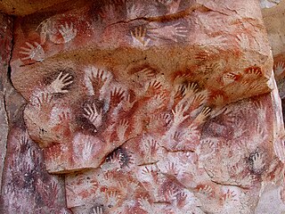
Cave paintings are a type of parietal art, found on the wall or ceilings of caves. The term usually implies prehistoric origin, and the oldest known are more than 40,000 years old, found in the caves in the district of Maros. The oldest are often constructed from hand stencils and simple geometric shapes. However, more recently, in 2021, cave art of a pig found in an Indonesian island, and dated to over 45,500 years ago, has been reported.
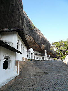
Dambulla is a town situated in the north of Matale District, Central Province of Sri Lanka. It is the second largest populated and urbanised centre after Matale in the Matale District. It is situated 148 km (92 mi) north-east of Colombo, 43 km (27 mi) north of Matale and 72 km (45 mi) north of Kandy. Due to its location at a major junction, it is the centre of major vegetable distribution in the country.

Wayanad, is an Indian district in the north-east of Kerala state with administrative headquarters at the municipality of Kalpetta. It is the only plateau in Kerala. The Wayanad Plateau forms a continuation of the Mysore Plateau, the southern portion of Deccan Plateau. It is set high in the Western Ghats with altitudes ranging from 700 to 2100 meters. Vellari Mala, a 2,240 m (7,349 ft) high peak situated on the trijunction of Wayanad, Malappuram, and Kozhikode districts, is the highest point in Wayanad district. The district was formed on 1 November 1980 as the 12th district in Kerala, by carving out areas from Kozhikode and Kannur districts. An area of 885.92 km2 of the district is forested. Wayanad has three municipal towns—Kalpetta, Mananthavady and Sulthan Bathery. There are many indigenous tribes in this area. The Kabini River, a tributary of Kaveri River, originates at Wayanad. Wayanad district, along with the Chaliyar valley in neighbouring Nilambur in Malappuram district, is known for natural gold fields, which are also seen in other parts of the Nilgiri Biosphere Reserve. Chaliyar river, which is the fourth longest river of Kerala, originates on the Wayanad plateau. The historically important Edakkal Caves are located in Wayanad district.

The Chera dynasty, IPA: [t͡ʃeːɾɐ], also known as the Keralaputra, was one of the principal lineages in and before the Sangam period history of the state of Kerala and the Kongu Nadu region of Western Tamil Nadu in southern India. Together with the Cholas of Uraiyur (Tiruchirappalli) and the Pandyas of Madurai, the early Cheras were known as one of the three major powers (muventar) of ancient Tamilakam in the early centuries of the Common Era.
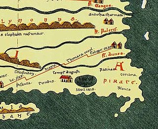
Muziris was an ancient harbour and an urban centre on the Malabar Coast. Muziris found mention in the Periplus of the Erythraean Sea, the bardic Tamil poems and a number of classical sources. Situated somewhere around the present day Kodungallur, the exact location of Muziris has been a matter of dispute among historians and archaeologists. However recent excavations at Pattanam, near North Paravur, has led to some experts suggesting that the city was located there.
Pattanam is a village located in the Ernakulam District in the southern Indian state of Kerala. It is located 2 km north of North Paravur, 6 km and East of Chendamangalam 25 km north of Kochi (Cochin).
Azhagiapandiapuram is a second grade town panchayat in Kanniyakumari district in the state of Tamil Nadu, India. It is located at the centre of Pazhayar valley. It is one of the four town panchayat's in Thovalai taluk.
Mala is a small town in Thrissur district of Kerala state, India. There is a Jewish synagogue in Mala town. At the moment, it is in ruins. The famous Pambu Mekkattu Mana (temple) is located here and attracts thousands of devotees every year.

Pech Merle is a cave which opens onto a hillside at Cabrerets in the Lot département of the Occitania region in France, about 32 km by road east of Cahors. It is one of the few prehistoric cave painting sites in France that remain open to the general public. Extending over 2 kilometres over two levels, of which only 1,200 m (3,900 ft) are open to the public, are caverns, wells and sloping tunnels, the walls of which are painted with dramatic murals dating from the Gravettian culture. Some of the paintings and engravings, however, may date from the later Magdalenian era.

Thrissur is the administrative capital of Thrissur District, in the central part of Kerala state, India. Thrissur district was formed on 1 July 1949. It is an important cultural centre, and is known as the Cultural Capital of Kerala. It is famous for the Thrissur Pooram festival, one of the most colourful and spectacular temple festival of Kerala. From ancient times, Thrissur has been politically, economically and culturally significant to the Indian subcontinent. It has opened the gates for Arabs, Romans, Portuguese, Dutch and English. According to tradition, Thrissur is where Christianity, Islam and Judaism entered the Indian subcontinent. Local Christian tradition holds that Thomas the Apostle arrived in 52 CE, and Muslim tradition states that Methala is the location of country's first mosque.
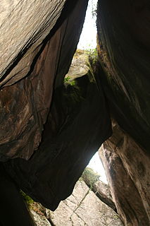
The Edakkal caves are two natural caves at a remote location at Edakkal, 25 km (15.5 mi) from Kalpetta in the Wayanad district of Kerala in India's Western Ghats. They lie 1,200 m (3,900 ft) above sea level on Ambukutty Mala, near an ancient trade route connecting the high mountains of Mysore to the ports of the Malabar coast. Inside the caves are pictorial writings believed to date to at least 6,000 BCE, from the Neolithic man, indicating the presence of a prehistoric settlement in this region. The Stone Age carvings of Edakkal are rare and are the only known examples from South India besides those of Shenthurini, Kollam also in Kerala.

Agastyaarkoodam is one of the peaks in the Western Ghats, Tirunelveli District of Tamil Nadu, India. This peak is a part of the Agasthyamala Biosphere Reserve which lies on the border between the Indian states of Tamil Nadu, Tirunelveli district and Kerala, Thiruvananthapuram district. The perennial Thamirabarani River originates from the eastern side of the range and flows into the Tirunelveli district of Tamil Nadu. It is 1,868-metres tall.

Chadayamangalam is a village located in Kollam District of southern India; Kerala. It is located along the Ithikkara river and the MC road that passes across the major urban locations of Kerala. It acts as centre for Chadayamangalam block panchayat, gram panchayat and assembly constituency. It hosts numerous government institutions including hospitals, schools and police station. Chadayamngalam is well noticed for newly constructed Jatayu Earth’s Center, which is a tourism centre in the town with the world’s largest bird sculpture..The place is also referred to as Jatayumangalam.

Ambalavayal is a village in Wayanad district in the state of Kerala, India. The Wayanad Heritage Museum is located in the village.
Thovarimala Ezhuthupara is a remotely located rock shelter in the Wayanad district of Kerala in India. Pre-historic stone age petroglyphs dating from around 1000 BC and after had been discovered here at a height of 500 m on Thovarimala. One can see the stone age rock engravings on the walls of these natural caves from top of Thovarimala. The rare historic treasure at Thovarimala throwing light into human habitation in the Wayanad area since ancient times, is yet to receive the protection of agencies like Archaeology Department, which preserves the Edakkal Caves just five kilometers away. The carvings, found on the upper side of the cave, depict few geometrical figures, an arrow, and one carving closely resembles a female genital organ. Recently more writings were located in this cave. The name Ezhuthupara means "writings on the stone."

The Malabar Coast is the southwestern coast of the Indian subcontinent. Geographically, it comprises the wettest regions of southern India, as the Western Ghats intercept the moisture-laden monsoon rains, especially on their westward-facing mountain slopes. The term is used to refer to the entire Indian coast from the western coast of Konkan to the tip of India at Kanyakumari. The peak of Anamudi, which is also the point of highest altitude in India outside the Himalayas, and Kuttanad, which is the point of least elevation in India, lie on the Malabar Coast. Kuttanad, also known as The Rice Bowl of Kerala, has the lowest altitude in India, and is also one of the few places in the world where cultivation takes place below sea level.

The Nedumala Caves are in Piralimattam. They are located on the border of Idukki district and Ernakulam District in Kerala state, India. Piralimattom Nedumala hills is a prehistoric site. Caves well carved on granite rock and stone shelter are here. According to P. Rajendran, an archaeologist and UGC Research Scientist, caves are points towards its chronology to the Neolithic period of around 4000 BC.

Meenangadi is an old town situated on the highway NH 766 between Kalpetta and Sulthan Bathery in Wayanad District, in Kerala, India. This place is one among the Provinces where the existence of Dolmens provide an historical evidence of earlier civilisation. Coffee bean, Black pepper, Ginger, Rice and Areca are the major crops cultivated in this area. Meenangadi is famous for its Fish Market and Cattle Market. The nearest railway station is at Kozhikode at 87 km and airport is Kannur International Airport with 94 km from Meenangadi. Meenangadi is surrounded by, Ambalavayal Panchayat, Kalpetta Taluk towards west, Gudalur Taluk towards East, Mananthavady Taluk towards west. Kalpetta, Sultan Bathery, Kozhikode are the nearby Cities and towns to Meenangadi.
Kerala's first carbon neutrality project launched in Meenangadi in June 2016. Upon achieving the goals of the project, Meenangadi will be the first village in India to go completely carbon neutral. Meenangadi has a population of 33450 According to 2011 Census with two Villages Purakkadi and (Part)Krishnagiri.
The Wayanad District of Kerala, India has a wide variety of tourist attractions ranging from religious sites to natural, and historical sites. This district is divided into three towns, Kalpetta, Sultan Bathery and Mananthavady. All Major Tourism destinations in the district are maintained by the District Tourism Promotion Council.
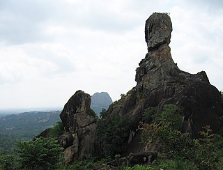
Phantom Rock is a tourist destination in Ambalavayal in the district of Wayanad in Kerala. It is a natural metamorphic rock formation resembling a human skull, and thus is known as Phantom Rock.


