Edmond, Kansas

Last updated

Edmond, Kansas
Norton County Kansas Incorporated and Unincorporated areas Edmond Highlighted.svg
Location within Norton County and Kansas
Map of Norton Co, Ks, USA.png
Coordinates: 39°37′37″N99°49′12″W / 39.62694°N 99.82000°W / 39.62694; -99.82000 [1]
Country United States
State Kansas
County Norton
Founded1870s
Incorporated 1916
Named for Jack Edmond
Area
[2]
  Total0.17 sq mi (0.43 km2)
  Land0.17 sq mi (0.43 km2)
  Water0.00 sq mi (0.00 km2)
Elevation
[1]
2,133 ft (650 m)
Population
 (2020) [3]
  Total28
  Density160/sq mi (65/km2)
Time zone UTC-6 (CST)
  Summer (DST) UTC-5 (CDT)
ZIP code
67645
Area code 785
FIPS code 20-19875
GNIS ID 2394623 [1]

Edmond is a city in Norton County, Kansas, United States. [1] As of the 2020 census, the population of the city was 28. [3]

Contents

History

Edmond had a post office from the 1870s until 1996. [4] Edmond was named for Jack Edmond, who offered a supply of flour in exchange for the naming rights. [5]

Geography

According to the United States Census Bureau, the city has a total area of 0.17 square miles (0.44 km2), all land. [6]

Demographics

Historical population
CensusPop.Note
1920 213
1930 197−7.5%
1940 180−8.6%
1950 110−38.9%
1960 91−17.3%
1970 90−1.1%
1980 56−37.8%
1990 37−33.9%
2000 4727.0%
2010 494.3%
2020 28−42.9%
U.S. Decennial Census

2020 census

The 2020 United States census counted 28 people, 12 households, and 8 families in Edmond. [7] [8] The population density was 168.7 per square mile (65.1/km2). There were 24 housing units at an average density of 144.6 per square mile (55.8/km2). [8] [9] The racial makeup was 89.29% (25) white or European American (89.29% non-Hispanic white), 0.0% (0) black or African-American, 7.14% (2) Native American or Alaska Native, 0.0% (0) Asian, 0.0% (0) Pacific Islander or Native Hawaiian, 0.0% (0) from other races, and 3.57% (1) from two or more races. [10] Hispanic or Latino of any race was 3.57% (1) of the population. [11]

Of the 12 households, 25.0% had children under the age of 18; 50.0% were married couples living together; 25.0% had a female householder with no spouse or partner present. 33.3% of households consisted of individuals and 25.0% had someone living alone who was 65 years of age or older. [8] The average household size was 3.2 and the average family size was 8.7. [12]

7.1% of the population was under the age of 18, 14.3% from 18 to 24, 17.9% from 25 to 44, 46.4% from 45 to 64, and 14.3% who were 65 years of age or older. The median age was 49.0 years. For every 100 females, there were 115.4 males. [8] For every 100 females ages 18 and older, there were 100.0 males. [8]

2010 census

As of the census [13] of 2010, there were 49 people, 23 households, and 15 families residing in the city. The population density was 288.2 inhabitants per square mile (111.3/km2). There were 31 housing units at an average density of 182.4 per square mile (70.4/km2). The racial makeup of the city was 98.0% White and 2.0% Native American.

There were 23 households, of which 26.1% had children under the age of 18 living with them, 60.9% were married couples living together, 4.3% had a female householder with no husband present, and 34.8% were non-families. 34.8% of all households were made up of individuals, and 4.3% had someone living alone who was 65 years of age or older. The average household size was 2.13 and the average family size was 2.73.

The median age in the city was 43.5 years. 20.4% of residents were under the age of 18; 4.1% were between the ages of 18 and 24; 26.5% were from 25 to 44; 36.8% were from 45 to 64; and 12.2% were 65 years of age or older. The gender makeup of the city was 53.1% male and 46.9% female.

2000 census

As of the census [14] of 2000, there were 47 people, 19 households, and 12 families residing in the city. The population density was 285.2 inhabitants per square mile (110.1/km2). There were 31 housing units at an average density of 188.1 per square mile (72.6/km2). The racial makeup of the city was 100.00% White. Hispanic or Latino of any race were 4.26% of the population.

There were 19 households, out of which 36.8% had children under the age of 18 living with them, 52.6% were married couples living together, 10.5% had a female householder with no husband present, and 31.6% were non-families. 26.3% of all households were made up of individuals, and 10.5% had someone living alone who was 65 years of age or older. The average household size was 2.47 and the average family size was 3.08.

In the city, the population was spread out, with 34.0% under the age of 18, 31.9% from 25 to 44, 21.3% from 45 to 64, and 12.8% who were 65 years of age or older. The median age was 40 years. For every 100 females, there were 113.6 males. For every 100 females age 18 and over, there were 82.4 males.

The median income for a household in the city was $11,875, and the median income for a family was $28,750. Males had a median income of $25,000 versus $12,500 for females. The per capita income for the city was $7,395. There were 20.0% of families and 25.6% of the population living below the poverty line, including 17.6% of under eighteens and none of those over 64.

Education

The community is served by Norton USD 211 public school district.

Related Research Articles

<span class="mw-page-title-main">Garnett, Kansas</span> City in Anderson County, Kansas

Garnett is a city in and the county seat of Anderson County, Kansas, United States. As of the 2020 census, the population of the city was 3,242.

<span class="mw-page-title-main">Lone Elm, Kansas</span> City in Anderson County, Kansas

Lone Elm is a city in Anderson County, Kansas, United States. As of the 2020 census, the population of the city was 27.

<span class="mw-page-title-main">Isabel, Kansas</span> City in Kiowa County, Kansas

Isabel is a city in Barber County, Kansas, United States. As of the 2020 census, the population of the city was 68.

<span class="mw-page-title-main">Latham, Kansas</span> City in Butler County, Kansas

Latham is a city in Butler County, Kansas, United States. As of the 2020 census, the population of the city was 96.

<span class="mw-page-title-main">Arcadia, Kansas</span> City in Crawford County, Kansas

Arcadia is a city in northeast Crawford County, Kansas, United States. As of the 2020 census, the population of the city was 254.

<span class="mw-page-title-main">Mulberry, Kansas</span> City in Crawford County, Kansas

Mulberry is a city in Crawford County, Kansas, United States. As of the 2020 census, the population of the city was 409.

<span class="mw-page-title-main">Jennings, Kansas</span> City in Decatur County, Kansas

Jennings is a city in Decatur County, Kansas, United States. As of the 2020 census, the population of the city was 81.

<span class="mw-page-title-main">Denton, Kansas</span> City in Doniphan County, Kansas

Denton is a city in Doniphan County, Kansas, United States. As of the 2020 census, the population of the city was 130.

<span class="mw-page-title-main">Gove City, Kansas</span> City in Gove County, Kansas

Gove City, more commonly known as Gove, is a city in and the county seat of Gove County, Kansas, United States. As of the 2020 census, the population of the city was 80.

<span class="mw-page-title-main">Randall, Kansas</span> City in Jewell County, Kansas

Randall is a city in Jewell County, Kansas, United States. As of the 2020 census, the population of the city was 79.

<span class="mw-page-title-main">Edgerton, Kansas</span> City in Kansas, United States

Edgerton is a city in Johnson County, Kansas, United States, and part of the Kansas City metropolitan area. As of the 2020 census, the population of the city was 1,748. It is home to a large BNSF intermodal train facility named Logistics Park Kansas City.

<span class="mw-page-title-main">Kingman, Kansas</span> City in Kingman County, Kansas

Kingman is a city in and the county seat of Kingman County, Kansas, United States. As of the 2020 census, the population of the city was 3,105.

<span class="mw-page-title-main">Lansing, Kansas</span> City in Kansas, United States

Lansing is a city in Leavenworth County, Kansas, United States. It is situated along the west side of the Missouri River and Kansas-Missouri state border. As of the 2020 census, the population of the city was 11,239. It is the second most populous city of Leavenworth County and is a part of the Kansas City metropolitan area. The Lansing Correctional Facility, which includes the state's main maximum-security prison, is located in Lansing.

<span class="mw-page-title-main">Meade, Kansas</span> City in Meade County, Kansas

Meade is a city in and the county seat of Meade County, Kansas, United States. As of the 2020 census, the population of the city was 1,505.

<span class="mw-page-title-main">Ness City, Kansas</span> City in Ness County, Kansas

Ness City is a city in and the county seat of Ness County, Kansas, United States. As of the 2020 census, the population of the city was 1,329. Ness City is famous for its four-story Old Ness County Bank Building located downtown, and nicknamed Skyscraper of the Plains.

<span class="mw-page-title-main">Lyndon, Kansas</span> City in Osage County, Kansas

Lyndon is a city in, and the county seat of Osage County, Kansas, United States. As of the 2020 census, the population of the city was 1,037.

<span class="mw-page-title-main">Ogden, Kansas</span> City in Riley County, Kansas

Ogden is a city in Riley County, Kansas, United States. As of the 2020 census, the population of the city was 1,661. It is located near Fort Riley between Manhattan and Junction City.

<span class="mw-page-title-main">Andale, Kansas</span> City in Sedgwick County, Kansas

Andale is a city in Sedgwick County, Kansas, United States. As of the 2020 census, the population of the city was 941.

<span class="mw-page-title-main">Mount Hope, Kansas</span> City in Sedgwick County, Kansas

Mount Hope is a city in Sedgwick County, Kansas, United States. As of the 2020 census, the population of the city was 806.
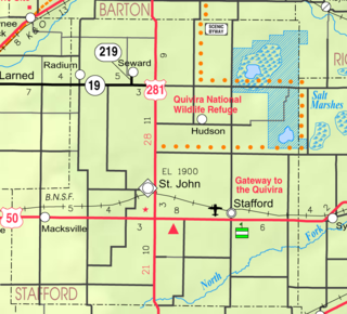
<span class="mw-page-title-main">Mayfield, Kansas</span> City in Sumner County, Kansas

Mayfield is a city in Sumner County, Kansas, United States. As of the 2020 census, the population of the city was 75.

References

  1. 1 2 3 4 U.S. Geological Survey Geographic Names Information System: Edmond, Kansas
  2. "2019 U.S. Gazetteer Files". United States Census Bureau. Retrieved July 24, 2020.
  3. 1 2 "Profile of Edmond, Kansas in 2020". United States Census Bureau. Archived from the original on February 27, 2022. Retrieved February 27, 2022.
  4. "Kansas Post Offices, 1828-1961". Kansas Historical Society. Archived from the original on October 9, 2013. Retrieved June 10, 2014.
  5. "Profile for Edmond, Kansas". ePodunk . Retrieved June 21, 2014.
  6. "US Gazetteer files 2010". United States Census Bureau. Archived from the original on January 25, 2012. Retrieved July 6, 2012.
  7. "US Census Bureau, Table P16: HOUSEHOLD TYPE". data.census.gov. Retrieved January 16, 2024.
  8. 1 2 3 4 5 "US Census Bureau, Table DP1: PROFILE OF GENERAL POPULATION AND HOUSING CHARACTERISTICS". data.census.gov. Retrieved January 16, 2024.
  9. Bureau, US Census. "Gazetteer Files". Census.gov. Retrieved December 30, 2023.
  10. "US Census Bureau, Table P1: RACE". data.census.gov. Retrieved January 16, 2024.
  11. "US Census Bureau, Table P2: HISPANIC OR LATINO, AND NOT HISPANIC OR LATINO BY RACE". data.census.gov. Retrieved January 16, 2024.
  12. "US Census Bureau, Table S1101: HOUSEHOLDS AND FAMILIES". data.census.gov. Retrieved January 16, 2024.
  13. "U.S. Census website". United States Census Bureau . Retrieved July 6, 2012.
  14. "U.S. Census website". United States Census Bureau . Retrieved January 31, 2008.

Further reading