Fairhaven, Kansas | |
|---|---|
 Fairhaven  Fairhaven | |
| Coordinates: 39°48′00″N99°40′56″W / 39.80000°N 99.68222°W | |
| Country | United States |
| State | Kansas |
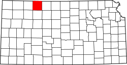
| County | Norton |
| Elevation | 2,326 ft (709 m) |
| Population | |
• Total | 0 |
| Time zone | UTC-6 (CST) |
| • Summer (DST) | UTC-5 (CDT) |
| GNIS ID | 482417 [1] |
Fairhaven is a ghost town in Norton County, Kansas, United States.