Related Research Articles

Chalk is a soft, white, porous, sedimentary carbonate rock. It is a form of limestone composed of the mineral calcite and originally formed deep under the sea by the compression of microscopic plankton that had settled to the sea floor. Chalk is common throughout Western Europe, where deposits underlie parts of France, and steep cliffs are often seen where they meet the sea in places such as the Dover cliffs on the Kent coast of the English Channel.
Petroleum geology is the study of origin, occurrence, movement, accumulation, and exploration of hydrocarbon fuels. It refers to the specific set of geological disciplines that are applied to the search for hydrocarbons.
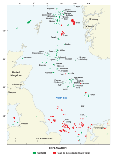
North Sea oil is a mixture of hydrocarbons, comprising liquid petroleum and natural gas, produced from petroleum reservoirs beneath the North Sea.

The Chalk Group is the lithostratigraphic unit which contains the Upper Cretaceous limestone succession in southern and eastern England. The same or similar rock sequences occur across the wider northwest European chalk 'province'. It is characterised by thick deposits of chalk, a soft porous white limestone, deposited in a marine environment.

Ekofisk is an oil field in block 2/4 of the Norwegian sector of the North Sea about 320 km (200 mi) southwest of Stavanger. Discovered in 1969 by Phillips Petroleum Company, it remains one of the most important oil fields in the North Sea. This was the first discovery of oil after the drilling of over 200 exploration wells in the North Sea "triggered" by the Groningen gas field discovery. In 1971, Phillips started producing directly to tankers from four subsea wells. Oil production is planned to continue until at least 2050.
Oseberg is an offshore oil field with a gas cap in the North Sea located 140 km (87 mi) northwest of the city of Bergen on the southwestern coast of Norway. The field, which is 25 km long by 7 km wide, was discovered in 1979 and its development is known to be one of the significant milestones in emergence of Norway's independent oil and gas industry. The Oseberg field was named after Oseberg ship, one of Norway's most significant archeological discoveries. The ancient Viking ship from the early 9th century was discovered in a 1904 historical excavation of a burial mound at the Oseberg Farm, south of Oslo.

A petroleum reservoir or oil and gas reservoir is a subsurface accumulation of hydrocarbons contained in porous or fractured rock formations.
The Danian is the oldest age or lowest stage of the Paleocene Epoch or Series, of the Paleogene Period or System, and of the Cenozoic Era or Erathem. The beginning of the Danian is at the Cretaceous–Paleogene extinction event 66 Ma. The age ended 61.6 Ma, being followed by the Selandian.

The Scollard Formation is an Upper Cretaceous to lower Palaeocene stratigraphic unit of the Western Canada Sedimentary Basin in southwestern Alberta. Its deposition spanned the time interval from latest Cretaceous to early Paleocene, and it includes sediments that were deposited before, during, and after the Cretaceous-Paleogene (K-Pg) extinction event. It is significant for its fossil record, and it includes the economically important coal deposits of the Ardley coal zone.

The Sirte Basin is a late Mesozoic and Cenozoic triple junction continental rift along northern Africa that was initiated during the late Jurassic Period. It borders a relatively stable Paleozoic craton and cratonic sag basins along its southern margins. The province extends offshore into the Mediterranean Sea, with the northern boundary drawn at the 2,000 meter (m) bathymetric contour. It borders in the north on the Gulf of Sidra and extends south into northern Chad.

In petroleum geology, a trap is a geological structure affecting the reservoir rock and caprock of a petroleum system allowing the accumulation of hydrocarbons in a reservoir. Traps can be of two types: stratigraphic or structural. Structural traps are the most important type of trap as they represent the majority of the world's discovered petroleum resources.
The Gulf of Suez Rift is a continental rift zone that was active between the Late Oligocene and the end of the Miocene. It represented a continuation of the Red Sea Rift until break-up occurred in the middle Miocene, with most of the displacement on the newly developed Red Sea spreading centre being accommodated by the Dead Sea Transform. During its brief post-rift history, the deepest part of the remnant rift topography has been filled by the sea, creating the Gulf of Suez.

The Cardium Formation is a stratigraphic unit of Late Cretaceous age in the Western Canada Sedimentary Basin. It takes the name from the fossilized heart-shaped cockle shells in the family Cardiidae present. It was first described along the Bow River banks by James Hector in 1895. It is present throughout western Alberta and in northeastern British Columbia, and it is a major source of petroleum and natural gas.
The Aachen Formation is an Upper Cretaceous geologic formation in the southern Netherlands and northeastern Belgium and adjacent Germany.
The Duvernay Formation is a stratigraphical unit of Frasnian age in the Western Canadian Sedimentary Basin.

The Seven Rivers Formation is a geologic formation in southeastern New Mexico and west Texas. It preserves fossils dating back to the late Guadalupian Epoch of the Permian period.
The Cattamarra Coal Measures is an Early Jurassic geological unit in Western Australia.

The Rødvig Formation is a geological formation deposited during the earliest part of the Danian and it was first identified by Richard Taylor and Richard Phillips in 1827. It is known from exposures at Stevns Klint in Denmark. The unit lies directly above the K–Pg boundary and contains fossils that provide a record of the recovery of various groups following the Cretaceous–Paleogene extinction. The upper boundary of the formation is an unconformity in the form of a hardground, beneath which the formation is sometimes missing. The base of the unit is irregular due to the presence of mounding associated with bryozoa, causing variations in thickness. The unit is subdivided into the lower Fiskeler Member mainly formed of marl and the overlying Cerithium Limestone Member.
The Tor Formation is a geological formation of late Campanian to Maastrichtian age. It forms the part of the Chalk Group in the North Sea. It is an important reservoir for oil and gas in fields such as Valhall. It overlies the Hod Formation. It underlies the Ekofisk Formation with local evidence of unconformity.
References
- ↑ NPD. "Ekofisk Fm". Norwegian Petroleum Directorate Fact Pages. Retrieved 25 August 2022.
- ↑ British Geological Survey. "Ekofisk Formation". The BGS Lexicon of Named Rock Units. Retrieved 26 August 2022.
- ↑ DINOloket. "Ekofisk Formation". Stratigraphic nomenclature. Retrieved 26 August 2022.
- ↑ Blinkenberg, K.H.; Anderskouv, K.; Sheldon, E.; Bjerrum, C.J.; Stemmerik, L. (2020). "Stratigraphically controlled silicification in Danian chalk and its implications for reservoir properties, southern Danish Central Graben". Marine and Petroleum Geology. 115. doi:10.1016/j.marpetgeo.2019.104134.