El Calvario

Last updated
El Calvario
Municipality and town
Flag of El Calvario (Meta).svg
Flag
Escudo de El Calvario (Meta).svg
Seal
Colombia - Meta - El Calvario.svg
Location of the municipality and town of El Calvario in the Meta Department of Colombia.
CountryFlag of Colombia.svg  Colombia
Department Meta Department
Elevation
1,987 m (6,519 ft)
Time zone UTC-5 (Colombia Standard Time)
Climate Af/Cfb

El Calvario is a town and municipality in the Meta Department, Colombia. It was the epicenter of the 2008 Colombia earthquake.

Climate

El Calvario has a borderline subtropical highland climate (Köppen Cfb)/tropical rainforest climate (Af) with mild mornings, warm afternoons and heavy to very heavy rainfall year-round.

Climate data for El Calvario
MonthJanFebMarAprMayJunJulAugSepOctNovDecYear
Average high °C (°F)23.8
(74.8)
24.1
(75.4)
24.1
(75.4)
23.5
(74.3)
23.0
(73.4)
22.1
(71.8)
22.2
(72.0)
22.4
(72.3)
22.8
(73.0)
23.1
(73.6)
22.9
(73.2)
23.1
(73.6)
23.1
(73.6)
Daily mean °C (°F)18.1
(64.6)
18.6
(65.5)
19.2
(66.6)
19.0
(66.2)
18.8
(65.8)
18.1
(64.6)
18.1
(64.6)
18.0
(64.4)
18.0
(64.4)
18.3
(64.9)
18.2
(64.8)
17.9
(64.2)
18.4
(65.1)
Average low °C (°F)12.4
(54.3)
13.1
(55.6)
14.3
(57.7)
14.6
(58.3)
14.6
(58.3)
14.2
(57.6)
14.0
(57.2)
13.7
(56.7)
13.3
(55.9)
13.6
(56.5)
13.5
(56.3)
12.8
(55.0)
13.7
(56.6)
Average rainfall mm (inches)66.3
(2.61)
112.4
(4.43)
134.2
(5.28)
345.7
(13.61)
427.3
(16.82)
452.1
(17.80)
521.2
(20.52)
431.9
(17.00)
274.4
(10.80)
221.2
(8.71)
166.6
(6.56)
82.2
(3.24)
3,235.5
(127.38)
Average rainy days81014222525272522201711226
Source 1: IDEAM [1]
Source 2: Climate-Data.org [2]

Related Research Articles

Arctic Archipelago Group of islands in the Arctic Ocean, off the coast of northern Canada

The Arctic Archipelago, also known as the Canadian Arctic Archipelago, is an archipelago lying to the north of the Canadian continental mainland, excluding Greenland.

Belmira Municipality and town in Antioquia Department, Colombia

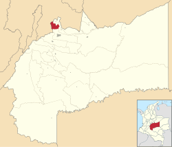
Belmira is a town and municipality in the northern subregion of the Colombian department of Antioquia. Approximately 62km from the city of Medellin.

Necoclí Municipality and town in Antioquia Department, Colombia

Necoclí is a town and municipality in Antioquia Department, Colombia. It is on the eastern shore of the Gulf of Urabá.

San Juan de Urabá Municipality and town in Antioquia Department, Colombia

San Juan de Urabá is a town and municipality in the Colombian department of Antioquia.

Pueblo Bello village in Caribbean, Colombia

Pueblo Bello, is a village and municipality in the northern region of the Department of Cesar, Colombia. It is located in the mountains of the Sierra Nevada de Santa Marta and is home to Amerindians pertaining to the Arhuaco ethnicity, whom consider Pueblo Bello a sanctuary but by the name of Arumake in their language. Pueblo Bello is the main producer of coffee in the Caribbean Region of Colombia.

Bolívar, Santander Municipality and town in Santander Department, Colombia

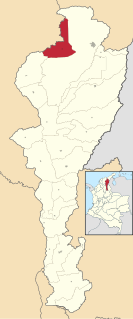
Bolívar is a town and municipality in the Santander Department in northeastern Colombia.

El Guacamayo Municipality and town in Santander Department, Colombia

El Guacamayo is a town and municipality in the Santander Department in northeastern Colombia.

Puente Nacional, Santander Municipality and town in Santander Department, Colombia

Puente Nacional is a town and municipality in the Saravita Valley, part of the Santander Department of northeastern Colombia.

Sucre, Santander Municipality and town in Santander Department, Colombia

Sucre is a town and municipality in the Santander Department in northeastern Colombia.

El Carmen de Atrato Municipality and town in Chocó Department, Colombia

El Carmen de Atrato is a municipality and town in the Chocó Department, Colombia.

Litoral del San Juan Municipality and town in Chocó Department, Colombia

Litoral del San Juan is a municipality and town in the Chocó Department, Colombia.

Orocué Municipality and town in Orinoquía Region, Colombia

Orocué is a town and municipality in the Department of Casanare, Colombia, located on the shore of the Meta River. Historically, it went by the name San Miguel del Macuco.

Pajarito, Boyacá Municipality and town in Boyacá Department, Colombia

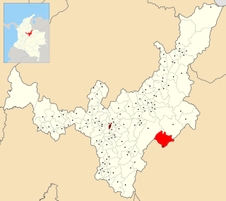
Pajarito is a town and municipality in the La Libertad Province, part of the Colombian department of Boyacá. The municipality, situated in the southeast of the department borders Labranzagrande and Aquitania of the department of Boyacá and Yopal, Recetor and Aguazul of the department of Casanare. The urban centre is located at a distance of 147 kilometres (91 mi) from the department capital Tunja at an altitude of 800 metres (2,600 ft) in a tight valley, not allowing much expansion of the urban area. The centre is experiencing periodic landslides.

Campohermoso Municipality and town in Boyacá Department, Colombia

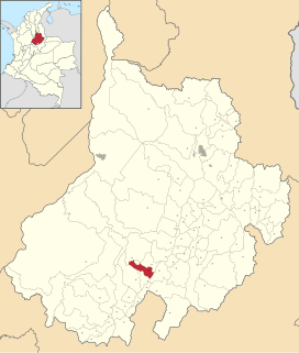
Campohermoso is a town and municipality in the Colombian Department of Boyacá, part of the subregion of the Lengupá Province.

Arcabuco Municipality and town in Boyacá Department, Colombia

Arcabuco is a town and municipality in the Ricaurte Province, part of the Colombian Department of Boyacá. Arcabuco is situated on the Altiplano Cundiboyacense with the urban centre at an altitude of 2,739 metres (8,986 ft). The municipality borders Moniquirá and Gámbita in the north, Villa de Leyva and Chíquiza in the south, Cómbita in the east and Gachantivá and Villa de Leyva in the west. The department capital Tunja is 34 kilometres (21 mi) to the south.

Cubarral Municipality and town in Meta Department, Colombia

Cubarral is a town and municipality in the Meta Department, Colombia.

Restrepo, Meta Municipality and town in Meta Department, Colombia

Restrepo is a town and municipality in the Meta Department, Colombia.

El Charco Municipality and town in Nariño Department, Colombia

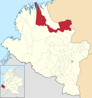
El Charco is a town and municipality in the Nariño Department, Colombia.

La Tola Municipality and town in Nariño Department, Colombia

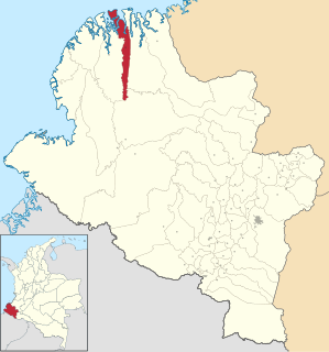
La Tola is a town and municipality in the Nariño Department, Colombia.

Santa Bárbara, Nariño Municipality and town in Nariño Department, Colombia

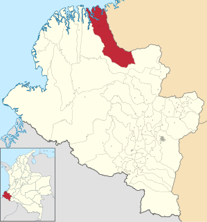
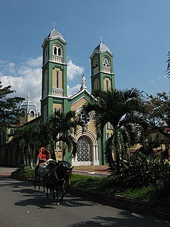
Santa Bárbara is a town and municipality in the Nariño Department, Colombia. Its municipal seat is known as Iscuandé.

References

  1. "Data". www.ideam.gov.co. Retrieved 2020-08-26.
  2. "Climate: El Calvario". Climate-Data.org. Retrieved August 26, 2020.

Coordinates: 4°25′N73°40′W / 4.417°N 73.667°W / 4.417; -73.667