Álvaro Uribe Vélez is a Colombian politician who served as the 31st President of Colombia from 7 August 2002 to 7 August 2010.

Sevilla is a town and municipality in the Valle del Cauca Department, Colombia. Widely recognized and famous as one of the best Colombian coffee producers. It is also known as the "Coffee Capital of Colombia" In 2003, it had a population of approximately 60,000 inhabitants.
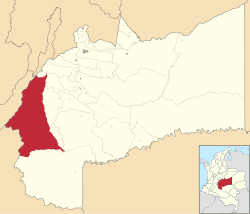
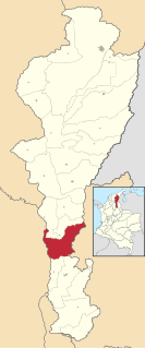
Ataco is a town and municipality located in the Tolima department of Colombia. The population of the municipality was 13,470 in the 2018 census.
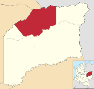
Concordia is a town and municipality in the Colombian department of Antioquia. Part of the subregion of Southwestern Antioquia.

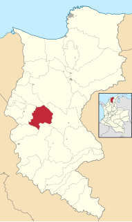
San Carlos is a town and municipality in the Colombian department of Antioquia, part of the subregion of Eastern Antioquia. It is called the hydro-electrical capital of Colombia, because it has many dams and it produces much energy.
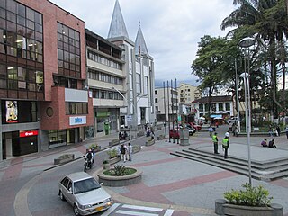
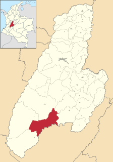
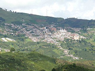
Calarcá is a municipality in the eastern part of the department of Quindío, Colombia. It is located 4 km east of the departmental capital Armenia. Its nickname is La Villa del Cacique in homage of its writers. The city was founded in 1886 by Segundo Henao during the time of colonization by people from Antioquia Department. It is the second city in Quindío with major quantity of inhabitants. In 2016 it had an estimated population of 78,779, of which 59,986 live in the main urban zone. Located along the Colombian coffee growing axis, it was made part of the "Coffee Cultural Landscape" UNESCO World Heritage Site in 2011.
La Gloria is a municipality and town in the Department of Cesar, northern Colombia by the Magdalena River.

Uribia is town and municipality of the La Guajira department of Colombia. It is the youngest municipality of this Department since the year 2000. Northern Zone of the Cerrejón coal mines are located in this municipality. The municipality also contains the Serranía de Macuira mountain range which is an isolated low altitude mountain range in the middle of La Guajira Desert. One third of this mountain range is also a National Natural Park of Colombia.

Dibulla is a town and municipality located in the Department of La Guajira, Colombia by the Caribbean sea and the Sierra Nevada de Santa Marta mountains on the Guajira Peninsula. It was proclaimed municipality in 1995.
Chibolo is a town and municipality of the Colombian Department of Magdalena. Chibolo was founded in 1820 and became a municipality on March 8, 1974. Its economy is based on farming, but also attracts by having a historic church of Saint Catherine of Alexandria and the Santa Catalina Plaza. Chibolo celebrated Carnivals, the Christian Holy Week, Day of Maria Auxiliadora every May 24, Virgen del Carmen, Saint Judas Thaddeus, town celebration of Saint Catherine of Alexandria on December 25.

El Piñón is a town and municipality of the Colombian Department of Magdalena. Officially founded in 1760 by Francisco Sayas, Ignacio Crespo, Vicente De la Hoz and others. On April 20, 1915 was proclaimed a municipality. Its economy is based on agriculture and farming. Its main tourist attraction is the Iglesia San Pedro Mártir and the Ave Maria Monument. The town celebrates carnivals, the Saint Peter of Verona Day in April, El Milagroso in September, the Unedited Song Festival and the Decimates Festival.

San Gil is a town municipality in the Department of Santander in northeastern Colombia, located roughly 300 km (192 mi) from Bogotá and 95 km from the department's capital, Bucaramanga. As of 2020, San Gil had a population of roughly 46,000 people within the total municipal area, making it the third largest urban area in the department, after Bucaramanga and Barrancabermeja. Founded in 1689, San Gil is over 300 years old. It was officially named the tourist capital of the region in 2004, thanks to its outdoor activity opportunities such as rafting, caving, kayaking and hiking.

Riosucio is a municipality and town in the Department of Chocó, Colombia. The municipality and town are located in the Atrato River basin, on the Chocoan side of Urabá, a region spanning the departments Chocó and Antioquia.

Granada is a town and municipality in the Meta Department, Colombia. The municipality area is 350 square kilometres (135 sq mi) and number of inhabitants 100 837. The municipality is located between 3° 26" latitude north and 73° 43" longitude west and between 372 and 410 metres above sea level. The daily mean air temperature varies between 24 and 25.6 °C. Annual rainfall is between 2,400 and 2,800 millimetres. The town is connected to Santa Fé de Bogotá along a 180 kilometres (110 mi) road and lies about 80 kilometres or 50 miles from the regional capital Villavicencio.

La Macarena is a town and municipality in the Meta Department, located about 280 km south of Bogotá, Colombia.

Lejanías is a town and municipality in the Meta Department, Colombia.

Mesetas is a town and municipality in the Meta Department, Colombia.

Vista Hermosa is a town and municipality in the Meta Department, Colombia. That is located approximately 6 hours from Bogotá D.C. It has fully paved access roads that allow a quick movement to the urban area and the visualization of its beautiful landscapes that live up to its name.
La Primavera is a town and municipality located in the Department of Vichada, Colombia.

Chingaza National Natural Park is located in the Eastern Ranges of the Colombian Andes, northeast of Bogotá, Colombia in the departments of Cundinamarca and Meta. The elevation in the park, to the east of the Altiplano Cundiboyacense, ranges from 800 metres (2,600 ft) to 4,020 metres (13,190 ft), and the temperature ranges from 4 to 21.5 °C. The park extends over the Cundinamarca municipalities La Calera, Fómeque, Guasca and San Juanito (Meta).