
Adjuntas is a small mountainside town and municipality in Puerto Rico located central midwestern portion of the island on the Cordillera Central, north of Yauco, Guayanilla, and Peñuelas; southeast of Utuado; east of Lares and Yauco; and northwest of Ponce. Adjuntas is spread over 16 barrios and Adjuntas Pueblo. Adjuntas is about two hours by car westward from the capital, San Juan.

Cerro Maravilla is Puerto Rico's fourth highest peak at 1,205 meters (3,953 ft). It is located on the northern edge Barrio Anón in Ponce, close to the border with the municipality Jayuya, and is part of the Cordillera Central. It is known as El Cerro de los Mártires and characterized as the most infamous peak in Puerto Rico, due to the 1978 Cerro Maravilla murders which took place here.
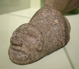
Yúcahu —also written as Yucáhuguama Bagua Maórocoti, Yukajú, Yocajú, Yokahu or Yukiyú— was the masculine spirit of fertility in Taíno mythology. He was the supreme deity or zemi of the Pre-Columbian Taíno people along with his mother Atabey who was his feminine counterpart. Dominant in the Caribbean region at the time of Columbus’ First voyages of Discovery, the peoples associated with Taíno culture inhabited the islands of the Bahamas, the Greater Antilles, and the Lesser Antilles.

Cerro de Punta or just Cerro Punta is the highest peak in Puerto Rico, rising to 1,338 meters (4,390 ft) above sea level. The mountain is part of the Cordillera Central and is located in the municipality of Ponce.

The Sierra Morena is one of the main systems of mountain ranges in Spain. It stretches for 450 kilometres from east to west across the south of the Iberian Peninsula, forming the southern border of the Meseta Central plateau and providing the watershed between the valleys of the Guadiana to the north and the west, and the Guadalquivir to the south.

Villa Guerrero Municipality is located in the north of the state of Jalisco, México, between 103°22′30″ and 103°50′00″ longitude west and 21°54′00″ and 22°10′00″ latitude north, at an altitude of 1,767 metres (5,797 ft) above sea level. The municipality covers an area of 1,092 square kilometres (422 sq mi).

Cordillera Central, is the main mountain range in Puerto Rico. The range crosses the island from west to east and divides it into its northern and southern coastal plains. The Cordillera Central runs eastward from the municipality of Maricao in the west to Aibonito in the central eastern region, and on to the Caribbean in the southeast through the Sierra de Cayey. The Central Mountain Range consists of the Cordillera Central proper and numerous subranges, foothills and ridges that extend throughout the island. Cerro de Punta is both the highest peak of the Cordillera Central and the highest point in Puerto Rico. The Sierra de Luquillo, where El Yunque is located, is sometimes included as a subrange or eastward extension of the Cordillera Central.
Félix Sánchez Olympic Stadium is a multi-purpose stadium in Santo Domingo, Dominican Republic, built in 1974 for the XII Central American & Caribbean Games.

Puerto Rico Highway 10 (PR-10) is a major highway in Puerto Rico. The primary state road connects the city of Ponce in the south coast to Arecibo in the north; it is also the shortest route between the two cities.

Puerto Rico Highway 123 (PR-123) is a secondary highway that connects the city Arecibo to the city of Ponce. It runs through the towns of Utuado and Adjuntas, before reaching Ponce. A parallel road is being built, PR-10, that is expected to take on most of the traffic currently using PR-123.

Río Portugués is a river in the municipality of Ponce, Puerto Rico. In the 19th century, it was also known as Río de Ponce. Twenty-one bridges for motor vehicle traffic span Río Portugués in the municipality of Ponce alone. The river is also known as Río Tibes in the area where it flows through barrio Tibes in the municipality of Ponce. Río Portugués has a length of nearly 30 kilometers (19 mi) and runs south from the Cordillera Central mountain range into the Caribbean Sea. The Portugués is one of the best-known rivers in Ponce because of its prominent zigzagging through the city and its historical significance. The river is historically significant because the city of Ponce had its origins on its banks. It was originally known as Río Baramaya. It has its mouth at 17°58′51″N66°37′26″W. This river is one of the 14 rivers in the municipality.

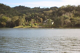
Toro Negro State Forest is one of the 21 forests that make up the public forests system in Puerto Rico. It is also Puerto Rico's highest cloud forest. It is in the Cordillera Central region of the island and covers 8,204 cuerdas, of mountains. Toro Negro's mountains have heights reaching up to 4,400 feet (1,300 m) and include Cerro de Punta, Cerro Jayuya and Cerro Rosa, the three highest peaks in the island. Nested among these mountains is Lake Guineo, the island's highest lake. The forest has 18 kilometers (11 mi) of trails, an observation tower, two natural swimming pools (Spanish:"charcos"), camping and picnic areas, nine rivers, and numerous creeks and waterfalls. The forest spans areas within the municipalities of Ponce, Jayuya, Orocovis, Ciales, and Juana Díaz, and consists of seven non-contiguous tracts of land. The largest contiguous segment of the forest is located in the municipalities of Ponce and Jayuya. Some 40% of the area of Toro Negro State Forest is located in Ponce's Barrio Anón.

The Río Grande de Arecibo is a river of Puerto Rico. The headwaters lie in the mountains to the south of Adjuntas. From there it flows north until it reaches the Atlantic Ocean near Arecibo. The tributaries lie along the side of the Cerro de Punta and the Utuado pluton. It flows through the northern, passing along a gorge that is 200 m deep and 800–1,200 m wide. It flows through the middle of Puerto Rico.

The Yahuecas River is a river of Adjuntas, Puerto Rico. This river aids the hydroelectric dams named Yauco I and Yauco II.

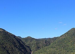
A breast-shaped hill is a hill in the shape of a breast. Some such hills are named "Pap", an archaic word for the breast or nipple of a woman. Such anthropomorphic geographic features are to be found in different places of the world and in some cultures they were revered as the attributes of the Mother Goddess, such as the Paps of Anu, named after Anu, an important female deity of pre-Christian Ireland.
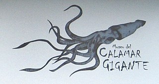
Museo del Calamar Gigante is a natural history museum located in Luarca, Asturias, Spain.
Garzas is a rural barrio in the municipality of Adjuntas, Puerto Rico. Its population in 2010 was 1,337.

Guilarte State Forest is one of the 20 forests that make up the public forests system in Puerto Rico. The forest is located in the eastern half of the Central Mountain Range or Cordillera Central. The main geographical feature of the forest reserve is Monte Guilarte, which is Puerto Rico's 7th highest mountain at 3,950 feet above sea level. While Monte Guilarte is located in the municipality of Adjuntas, the forest's borders also include parts of Guayanilla, Peñuelas and Yauco.
The Planadas-Yeyesa Nature Reserve is a protected nature reserve located in the Sierra de Cayey, in the municipality of Salinas in central Puerto Rico. The reserve is located close to the famous Cerro Las Tetas. Two of the most prominent features of the reserve are Cerro Planada, a 2,480 feet high mountain peak, and La Yeyesa, a heavily forested canyon formed by the Lapa River and other streams which feed into the Nigua River. La Yeyesa can be accessed through a lightly trafficked yet moderate trail.
Cerro Gregorio is a mountain of the Sierra de Cayey measuring 2,043 feet in elevation. The mountain is located in the barrios Jagual and Quebrada Honda in the municipality of San Lorenzo, Puerto Rico, close to the municipal boundary with Caguas. The mountain is the site of El Cerro de Nandy, a restaurant and local tourism destination.

