Cordillera Central | |
---|---|
Highest point | |
Peak | Cerro de Punta |
Elevation | 4,390 ft (1,340 m) |
Coordinates | 18°10′21″N66°35′31″W / 18.17250°N 66.59194°W |
Geography | |
Location of the highest point of the Cordillera Central in Puerto Rico. | |
Location | Puerto Rico |
Region | Caribbean |
The Cordillera Central (English: Central Mountain Range), is the main mountain range in Puerto Rico. The range crosses the island from west to east and divides it into its northern and southern coastal plains. The Cordillera Central runs eastward from the municipality of Maricao in the west to Aibonito in the central eastern region, and on to the Caribbean in the southeast through the Sierra Cayey .
The Central Mountain Range consists of the Cordillera Central proper and numerous subranges (such as the Sierra de Cayey), foothills and ridges that extend throughout the island. [1] Cerro de Punta is both the highest peak of the Cordillera Central and the highest point in Puerto Rico. The Sierra de Luquillo, where El Yunque is located, is sometimes included as a subrange or eastward extension of the Cordillera Central. [2]
The region of the Cordillera Central has been inhabited since the pre-Hispanic era. During the Spanish colonization of Puerto Rico, the Cordillera Central was likely shared by different Taíno cacicazgos or chiefdoms: Yagüecax, Otoao, Jatibonico, Guaynia and Turabon. [3] [4] Many of the indigenous Taínos fled to the central mountainous region during the Spanish conquest of Borinquen, and the region today hosts a number of related archaeological sites. [5]
Throughout the history of Puerto Rico, this mountain range has been important for the economy of the island. Due to its climate, the range has been ideal for the cultivation of fruit, vegetables and, most famously, coffee. The coffee cultivation and production in the Cordillera Central intensified throughout the 19th century. This helped develop the mountainous region of the island and attracted a high influx of immigrants from coastal cities such as San Juan and Ponce, but also from Europe thanks to the Royal Decree of Graces of 1815 which encouraged non-Spanish Europeans to settle and cultivate the land. Coffee was one of the most lucrative industries of the region at the time, and it was developed particularly by Corsican immigrants. [6] [7]
The first paved road to span the mountain range was the Carretera Central, which was functional by 1886 and completed in 1898, connecting San Juan in the Atlantic coast to Ponce in the Caribbean coast. Many of the workers involved in its construction were confined Chinese workers from Cuba between the years 1865 and 1880. [8] The original road goes through the municipalities of San Juan (formerly the municipality of Río Piedras), Guaynabo, Caguas, Cidra, Cayey, Aibonito, Coamo, Juana Díaz and Ponce. This was the most important engineering project built by the Spanish government in Puerto Rico during the 19th century and it highly influenced the human development of the region. The original route is now listed in the US National Register of Historic Places. This road is also known as the Military Road (Spanish: Carretera Militar) for its strategic importance and it was used both by the Spanish and US Army during the Puerto Rico campaign of the Spanish-American War of 1898. [9] [10] [11]
The Puerto Rico Central Mountain Range or Cordillera Central is considered the largest of the three geographical and physiographic provinces of the island, along with the Karst regions and the coastal plains. [2] The mountain range begins in the western part of the island in the municipalities of Maricao, Las Marías and Mayagüez close to the Mona Passage in the west coast of Puerto Rico. Another western portion of the range that is sometimes included in the Cordillera Central, called the Santa Marta Hills, is located to the southwest in the municipalities of Sabana Grande, San Germán, Lajas and Cabo Rojo. This subrange forms the division between the Lajas Valley and the Guanajibo or Sabana Grande Valley, and it connects to the main range of the Cordillera Central in the border between Yauco and Sabana Grande. The Cordillera Central proper keeps eastward through the municipalities of Maricao, Lares, Utuado, Yauco, Adjuntas, Guayanilla, Peñuelas, Ponce, Jayuya, Juana Díaz, Villalba, Ciales, Orocovis, Corozal, Barranquitas, Coamo, Comerío and Aibonito; this section contains the highest peaks of the range and Puerto Rico, such as Cerro de Punta which is the highest point in the island. The Aibonito Pass (also known as Asomante Pass) creates a division between the Cordillera Central proper and its eastward subrange, the Sierra de Cayey, which crosses Cayey, Salinas, Guayama, Caguas, San Lorenzo and Patillas. From this point the range splits in two ridges (often called cuchillas in Spanish): the Sierra de Guardarraya between Patillas and Maunabo in the north, and the Sierra Pandura between Maunabo and Yabucoa in the south; these two small ranges end in the southeastern coast of Puerto Rico next to the Caribbean Sea, forming the plains of the Valley of Maunabo between them. [12] [13] [14] [15]
The Sierra de Luquillo is often included as a subrange of the Cordillera Central, [1] however it is separated from it by the Loíza hydrological basin in the Caguas Valley and numerous other geographical features such as the San Lorenzo batholith. [16]
The northern edge of the Cordillera Central was formed throughout millions of years through the interactions between the North American and Caribbean plate tectonics. The relief was shaped by an accordion-like motion between both plate tectonics through subduction and transform fault line collisions. In addition to the seismic orogeny, the central mountain ranges are also the product of volcanic activity from 120 million years ago in the Early Cretaceous period, and what is the Cordillera Central today used to be the tips of small islands surrounding larger volcanic islands. [17] [18]
Given its volcanic origin, most of the rocks are of Eocene, Paleocene and Cretaceous volcanic and sedimentary composition. There are also deposits of intrusive rock, composed of quartz diorite, diorite and granodiorite, in addition to alluvium in the central and northern regions, and metamorphic serpentine sedimentary and igneous rock in the western portion. [19]
The Cordillera Central is home to most of the endemic plant and animal species in Puerto Rico. The majority of the range is home to Puerto Rican moist forests, belonging to both the tropical and subtropical moist broadleaf forest ecoregion of the Caribbean. This habitat style is often known as jungle (Spanish: selva) and it extends to other geographical provinces of the island such as the karst zones and the coastal lowlands. [20]
The Cordillera Central is home to several types of forests such as the tropical montane forest, which includes the cloud and dwarf forests, and the subtropical moist forest. Trees at middle elevations tend to be the tallest while those closer to the mountain summits tend to be smaller. Some of the most common plant species are the West Indian treefern ( Cyathea arborea ), the trumpet tree ( Cecropia peltata ), the nemoca tree ( Ocotea moschata ), the West Indian sumac ( Brunellia comocladifolia ), the yucca plum pine ( Podocarpus coriaceus ), the candlewood or tabonuco tree ( Dacryodes excelsa ), the bulletwood ( Manilkara bidentata ), the Puerto Rican magnolia ( Magnolia portoricensis ), the maga tree ( Thespesia grandiflora ), and the Sierra palm tree ( Prestoea montana ). The foothills are home to plants such as the coroso palm tree ( Acrocomia media ) and the West Indian locust ( Hymenaea courbaril ). Most of the endangered species are also endemic, and they include species such as the Cordillera maiden fern ( Amauropelta inabonensis ), only found in Cerro Rosa, Cook's holly ( Ilex cookii ) which is only found in Cerro de Punta and Mount Jayuya, and the palo de ramon ( Banara vanderbiltii ) of which only 20 wild individuals remain. The Caribbean pine (Pinus caribaea) and the West Indian ( Swietenia mahagoni ) and Honduran mahogany trees ( S. macrophylla ) have been introduced and successfully adapted to the mountain forests. [21] [22]
This region is home to a high number of endemic animal species, most of which are birds and amphibians. In addition to the common coqui ( Eleutherodactylus coqui ), the mountain forests are home to at least 10 other species of coqui ( Eleutherodactylus sp.), some of which are endangered. Some reptile species found in the forest are the Puerto Rican ground lizard (Pholidoscelis exsul), the blind worm lizard ( Amphisbaena caeca ), the endangered Puerto Rican boa (Chilabothrus inornatus) and the Puerto Rican racer ( Borikenophis portoricensis ). The most common birds are the Puerto Rican woodpecker (Melanerpes portoricensis), the Puerto Rican tody (Todus mexicanus), the Puerto Rican lizard cuckoo (Coccyzus vieilloti), the zenaida dove (Zenaida aurita), the Puerto Rican emerald hummingbird (Riccordia maugeaus) and the red-tailed hawk (Buteo jamaicensis). The Puerto Rican parrot ( Amazona vittata ) used to be very common in the region but it is now critically endangered; other endangered birds are the Puerto Rican broad-winged hawk, Bicknell's thrush and the Puerto Rican sharp-shinned hawk. [23] [24] [25]
The rivers and streams that originate in the mountains are home to species such as the mountain mullet (Dajaus monticola) and the gata shrimp ( Atya lanipes ). There is also a number of bat species found throughout the region including the Antillean ghost-faced bat (Mormoops blainvillei), the greater bulldog bat ( Noctilio leporinus ) and the sooty mustached bat (Pteronotus quadridens). The invasive small Indian mongoose (Urva auropunctata) and black rat ( Rattus rattus ) are very common and considered a threat to many endangered native species. [26] [27] [28]
The Central Mountain Range or Cordillera Central contains most of the protected state forests of Puerto Rico:
The Cordillera Central extends from west to east creating a geographic division between the north and the south of the island. The altitude of these mountains blocks the easterly trade winds and creates a rain shadow that cause the southern plains to have a drier and semi-arid weather than the more tropical humid weather found in the northern part of the island. The Cordillera is the rainiest region of Puerto Rico outside the Sierra de Luquillo. The rainiest periods are between the months of May and December, correlating with the wet season (often used interchangeably with hurricane season), with the months between December and March being relatively the driest. [29]
Some of the lowest temperatures in Puerto Rico have been recorded in mountain towns and municipalities located on or along the Cordillera Central. [30] [31] The lowest temperature ever recorded was of 38 °F (3 °C) in the eastern portion of the range at Aibonito in March 1911, followed by 40 °F (4 °C) in the central portion of the range at Adjuntas in 1966 and 1993. [32] [33] Based on the current global climate patterns it is impossible for it to snow in the Cordillera Central or anywhere else in Puerto Rico. [34]
The following table lists the 50 highest mountain peaks of Puerto Rico that are located in the Cordillera Central, including those of the Sierra de Cayey. Note that some unnamed peaks in the region are not included. [35]
Rank | Mountain Peak | Municipality and (Barrio) | Location Reference | Elevation | Elevation Reference |
---|---|---|---|---|---|
1 | Cerro de Punta | Ponce (Anón) | [36] [37] [38] [39] [40] [41] | 4,357 ft (1,328 m) | [42] [43] |
2 | Monte Jayuya | Jayuya (Saliente), Ponce (Anón) | [44] | 4,252 ft (1,296 m) | [42] |
3 | Cerro Rosa | Ciales (Toro Negro), Jayuya (Saliente) | [45] | 4,144 ft (1,263 m) | [42] |
4 | Piedra Blanca | Jayuya (Veguitas) | [46] | 4,042 ft (1,232 m) | [47] |
5 | Cerro Maravilla | Ponce (Anón) | [48] [49] | 3,960 ft (1,207 m) | [47] |
6 | Monte Guilarte | Adjuntas (Guilarte) | [50] | 3,934 ft (1,199 m) | [42] |
7 | Los Tres Picachos [51] | Ciales (Toro Negro), Jayuya (Coabey) | [52] | 3,894 ft (1,187 m) | [47] |
8 | Cerro Saliente | Jayuya (Saliente) | [53] | 3,845 ft (1,172 m) | [54] |
9 | Monte Membrillo | Yauco (Río Prieto) | [55] | 3,579 ft (1,091 m) | [47] |
10 | Cerro El Bolo | Orocovis (Ala de la Piedra), Villalba (Villalba Arriba) | [56] | 3,527 ft (1,075 m) | [54] |
11 | Cerro Doña Juana | Orocovis (Ala de la Piedra) | [57] | 3,471 ft (1,058 m) | [54] |
12 | Cerro Vaquiña | Adjuntas (Guilarte) | [58] | 3,369 ft (1,027 m) | [58] |
13 | Cerro Garrote | Peñuelas (Rucio) | [59] | 3,356 ft (1,023 m) | [59] |
14 | Cerrote de Peñuelas | Peñuelas (Rucio) | [60] | 3,307 ft (1,008 m) | [60] |
15 | Cerro El Gigante | Adjuntas (Saltillo) | [61] | 3,175 ft (968 m) | [61] |
16 | Cerro Morales | Jayuya (Jayuya Abajo), Utuado (Tetuán) | [62] | 3,126 ft (953 m) | [62] |
17 | Las Tres Palmas | Jayuya (Coabey) | [63] | 3,106 ft (947 m) | [63] |
18 | La Torrecilla | Barranquitas (Barrancas) | [64] | 3,057 ft (932 m) | [64] |
19 | Cerro Roncador | Utuado (Guaonico) | [65] | 3,038 ft (926 m) | [65] |
20 | Peña La Francia | Orocovis (Bauta Abajo) | [65] | 3,028 ft (923 m) | [65] |
21 | Cerro Prieto | Utuado (Viví Arriba) | [66] | 3,021 ft (921 m) | [66] |
22 | Cerro El Malo | Orocovis (Bermejales) | [67] | 3,005 ft (916 m) | [67] |
23 | Cerro Taita | Orocovis (Bauta Abajo) | [68] | 2,985 ft (910 m) | [68] |
24 | Cerro Novillo | Adjuntas (Portillo) | [69] | 2,952 ft (900 m) | [69] |
25 | Cerro La Santa | Caguas (San Salvador), Cayey (Farallón), San Lorenzo (Espino) | [70] | 2,903 ft (885 m) | [70] |
26 | Cerro Palo de Café | Jayuya (Mameyes Arriba) | [35] | 2,896 ft (883 m) | [35] |
27 | Cerro El Peligro | Guayanilla (Jagua Pasto, Quebrada Honda), Peñuelas (Macaná) | [71] | 2,890 ft (880 m) | [71] |
28 | Cerro Lloroso | Adjuntas (Tanamá, Yayales) | [72] | 2,883 ft (879 m) | [72] |
29 | Pico Rodadero | Yauco (Aguas Blancas, Duey, Sierra Alta) | [73] | 2,864 ft (873 m) | [73] |
30 | Cerro Pío | Orocovis (Damián Arriba, Saltos) | [74] | 2,841 ft (866 m) | [74] |
31 | Cerro Lucero | Caguas (San Salvador), Cayey (Farallón) | [75] | 2,831 ft (863 m) | [75] |
32 | Monte Hormiga | Adjuntas (Capáez) | [76] | 2,831 ft (863 m) | [76] |
33 | Cerro Medina | Adjuntas (Tanamá, Yayales) | [76] | 2,824 ft (861 m) | [76] |
34 | Cerro de La Tabla | Cayey (Jájome Alto), Guayama (Carite, Guamaní) | [76] | 2,808 ft (856 m) | [76] |
35 | Cerro Honoré | Patillas (Muñoz Rivera), San Lorenzo (Espino) | [77] | 2,795 ft (852 m) | [77] |
36 | Cerro Avispa | Cayey (Cercadillo) | [78] | 2,778 ft (847 m) | [78] |
37 | Cerro Magoyo | Jayuya (Mameyes Arriba) | [79] | 2,762 ft (842 m) | [79] |
38 | Cerro Las Tetas | Salinas (Lapa) | [80] | 2,759 ft (841 m) | [42] |
39 | Cerro La Chorrera | Adjuntas (Capáez), Utuado (Guaonico) | [81] | 2,739 ft (835 m) | [81] |
40 | Cerro Pulguillas | Coamo (Pulguillas) | [82] | 2,739 ft (835 m) | [82] |
41 | Cerro Curet | Yauco (Aguas Blancas) | [83] | 2,690 ft (820 m) | [83] |
42 | Cerro Mata de Plátano | Peñuelas (Jaguas) | [84] | 2,673 ft (815 m) | [84] |
43 | Monte El Gato | Cayey (Sumido) | [85] | 2,673 ft (815 m) | [85] |
44 | Cerro Garzas | Adjuntas (Garzas) | [86] | 2,641 ft (805 m) | [86] |
45 | Peña Domingo | Cayey (Pasto Viejo, Piedras) | [87] | 2,637 ft (804 m) | [87] |
46 | Cerro Don Quiño | Adjuntas (Yahuecas, Yayales) | [88] | 2,621 ft (799 m) | [88] |
47 | Cerro El Pico | Coamo (Pulguillas) | [89] | 2,598 ft (792 m) | [89] |
48 | Peñon de los Soldados | Cayey (Cercadillo), Salinas (Palmas) | [90] | 2,552 ft (778 m) | [90] |
49 | Cerro Mercado | Adjuntas (Portillo, Yahuecas) | [91] | 2,532 ft (772 m) | [91] |
50 | Cerro Farallón | Barranquitas (Quebradillas) | [92] | 2,552 ft (778 m) | [92] |
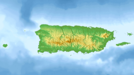
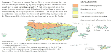
The geography of Puerto Rico consists of an archipelago located between the Caribbean Sea and the North Atlantic Ocean, east of Hispaniola, west of the Virgin Islands, and north of Venezuela. As the smallest and easternmost of the Greater Antilles, the main island of Puerto Rico is about 178 kilometers long and about 65 kilometers wide. With a land and internal costal water area of 9,100 square kilometres, it is the 4th largest in the Caribbean and 81st largest island in the world. Various smaller islands and cays, including Vieques, Culebra, Palomino, Mona, Desecheo, and Caja de Muertos, comprise the rest of the archipelago, with only Culebra and Vieques being inhabited year-round.
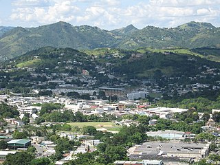
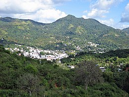
Cayey, officially Cayey de Muesas, is a mountain town and municipality in central Puerto Rico located on the Sierra de Cayey within the Central Mountain range, north of Salinas and Guayama; south of Cidra and Caguas; east of Aibonito and Salinas; and west of San Lorenzo. Cayey is spread over 21 barrios plus Cayey Pueblo. It is part of the San Juan-Caguas-Guaynabo Metropolitan Statistical Area.
Aibonito is a small mountain town and municipality in Puerto Rico located in the Sierra de Cayey mountain range, north of Salinas; south of Barranquitas and Comerío; east of Coamo; and west of Cidra, and Cayey. Aibonito is spread over 8 barrios and Aibonito Pueblo. It is part of the San Juan-Caguas-Guaynabo Metropolitan Statistical Area.
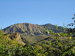
Cerro Maravilla is Puerto Rico's fourth highest peak at 1,205 meters (3,953 ft). It is located on the northern edge Barrio Anón in Ponce, close to the border with the municipality Jayuya, and is part of the Cordillera Central. It is known as El Cerro de los Mártires and characterized as the most infamous peak in Puerto Rico, due to the 1978 Cerro Maravilla murders which took place here.
Puerto Rico Highway 52 (PR-52), a major toll road in Puerto Rico, is also known as Autopista Luis A. Ferré. It was formerly called Expreso Las Américas. It runs from PR-1 in southwest Río Piedras and heads south until it intersects with highway PR-2 in Ponce. At its north end, the short PR-18 continues north from PR-52 towards San Juan. This short segment is known as Expreso Las Américas, the only segment of the route still unofficially bearing this name, since PR-18 is officially named Roberto Sánchez Vilella Expressway. The combined route of PR-18 and PR-52 runs concurrent with the unsigned Interstate Highway PRI-1. Toll stations are located in San Juan, Caguas, Salinas, Juana Díaz, and Ponce.
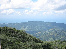
Cerro de Punta or Cerro Punta is the highest peak in Puerto Rico, rising to 1,338 meters (4,390 ft) above sea level. The mountain is part of the Cordillera Central and is located in the municipality of Ponce.
Guayama, officially the Autonomous Municipality of Guayama, is a city and municipality on the Caribbean coast of Puerto Rico. As of the 2020 U.S. Census, the city had a population of 36,614. It is the center of the Guayama metropolitan area with a population of 68,442 in 2020.
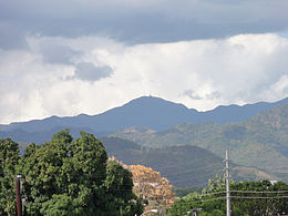
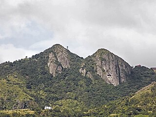
Cerro Las Tetas, nicknamed Las Tetas de Cayey but officially Las Piedras del Collado, are two mountain peaks located in the municipality of Salinas, Puerto Rico, north of the city of Salinas proper. Since September 1, 2000, the peaks have become part of the Las Piedras del Collado Nature Reserve and are protected by law. Their height is 2,762 feet (842 m) above sea level.
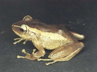
Eleutherodactylus portoricensis is a frog native to Puerto Rico that belongs to the family Eleutherodactylidae. Its vernacular English names are upland coqui, mountain coqui, and Puerto Rican robber frog. The species’ range spans the Luquillo Mountains of northeastern Puerto Rico and the Cordillera Central, which forms the highland “backbone” of Puerto Rico and includes an eastern extension beginning at the city of Cayey. However, the species is likely extirpated from the western Cordillera Central.
Puerto Rico Highway 1 (PR-1) is a highway in Puerto Rico that connects the city of Ponce to San Juan. Leaving Ponce, the road heads east and follows a somewhat parallel route along the southern coast of the island heading towards Salinas. At Salinas, the road turns north to cut through the Cordillera Central in its approach to San Juan. Before reaching San Juan, it climbs to make its way to the mountain town of Cayey and then it winds down into the city of Caguas on its final approach to San Juan.
Puerto Rico Highway 14 (PR-14) is a main highway connecting Ponce to Cayey, Puerto Rico. The road runs the same course as the historic Carretera Central. The Ponce-to-Coamo section of PR-14 was built under the direction of Spanish engineer Raimundo Camprubí Escudero.
The Ruta Panorámica, officially the Ruta Panorámica Luis Muñoz Marín, is a 167-mile (269 km) network of some 40 secondary roads which traverse the island of Puerto Rico from west to east along its Cordillera Central. Most of the route consists of three roads, PR-105, PR-143, and PR-182. The route starts in Mayagüez and ends in Maunabo. The first major segment of the route runs from Mayagüez to Maricao as Route 105, then from Adjuntas to Aibonito as Route 143, and then follows Route 182 toward Maunabo.
The Carretera Central is a historic north–south central highway in Puerto Rico, linking the cities of San Juan and Ponce by way of Río Piedras, Caguas, Cayey, Aibonito, Coamo, and Juana Díaz. It crosses the Cordillera Central. Plans for the road started in the first half of the 19th century, and the road was fully completed in 1898. At the time the United States took possession of Puerto Rico in 1898, the Americans called it "the finest road in the Western Hemisphere."
This portion of National Register of Historic Places listings in Puerto Rico is along the central mountain region, from Las Marías and Maricao in the central-west to Juncos in the central-east, including the slopes of the Cordillera.
Porta Cordillera, or simply Central Region, is a land-locked tourism region located in the central mountainous area of Puerto Rico. Porta Cordillera was officially launched in July 2012 by the Puerto Rico Tourism Company. It consists of 16 municipalities: Aguas Buenas, Cidra, Cayey, Comerío, Aibonito, Naranjito, Barranquitas, Corozal, Orocovis, Morovis, Ciales, Jayuya, Florida, Utuado, Adjuntas and Lares.
Cerro del Diablo is a mountain in the municipality of Ponce, Puerto Rico, located north-northwest of the city of Ponce. The 2,234-foot high hill sits at the foothills of the Cordillera Central and is located in Barrio Tibes.
The Sierra Cayey is a mountain range in the main island of Puerto Rico. It is located in the southeast section of the island. Its elevations do not exceed 1000 m .
Carite State Forest is a state forest and nature reserve located in the Sierra de Cayey mountain range in southeastern Puerto Rico. The forest extends over approximately 2,600 hectares and is located in the municipalities of Caguas, Cayey, Guayama, Patillas and San Lorenzo. The forest is located along the Ruta Panorámica, which offers access to the forest.
Cerro La Santa is a 2,962 feet high mountain and the highest point in the Sierra de Cayey in Puerto Rico. The peak of Cerro La Santa is located in the Carite State Forest, at a tri-point shared by the municipalities of Caguas, Cayey (Farallón) and San Lorenzo (Espino).
{{cite book}}
: CS1 maint: numeric names: authors list (link)