
Adjuntas is a small mountainside town and municipality in Puerto Rico located central midwestern portion of the island on the Cordillera Central, north of Yauco, Guayanilla, and Peñuelas; southeast of Utuado; east of Lares and Yauco; and northwest of Ponce. Adjuntas is spread over 16 barrios and Adjuntas Pueblo. Adjuntas is about two hours by car westward from the capital, San Juan. It is the principal city of and comprises the Adjuntas Micropolitan Statistical Area.
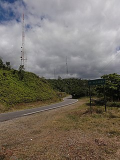
Cerro Maravilla is Puerto Rico's fourth highest peak at 1,205 meters (3,953 ft). It is located on the northern edge Barrio Anón in Ponce, close to the border with the municipality Jayuya, and is part of the Cordillera Central. It is known as El Cerro de los Mártires and characterized as the most infamous peak in Puerto Rico, due to the 1978 Cerro Maravilla murders which took place here.

El Yunque National Forest, formerly known as the Caribbean National Forest, is a forest located in northeastern Puerto Rico. It is the only tropical rainforest in the United States National Forest System and the United States Forest Service. El Yunque National Rainforest is located on the slopes of the Sierra de Luquillo mountains, encompassing 28,000 acres of land, making it the largest block of public land in Puerto Rico.
Jayuya is a town and municipality of Puerto Rico located in the mountainous center region of the island, north of Ponce; east of Utuado; and west of Ciales. Jayuya is spread over 10 barrios and Jayuya Pueblo. It is the principal city of the Jayuya Micropolitan Statistical Area.

Yauco is a town and municipality in southwestern Puerto Rico. Although the downtown is inland, the municipality stretches to a southern coast facing the Caribbean Sea. Yauco is located south of Maricao, Lares and Adjuntas; east of Sabana Grande and Guánica; and west of Guayanilla. The municipality consists of 20 barrios and Yauco Pueblo. It is both a principal town of the Yauco Metropolitan Statistical Area and the Ponce-Yauco-Coamo Combined Statistical Area.

Cerro de Punta or just Cerro Punta is the highest peak in Puerto Rico, rising to 1,338 meters (4,390 ft) above sea level. The mountain is part of the Cordillera Central and is located in the municipality of Ponce.

Cerro Las Tetas, nicknamed Las Tetas de Cayey but officially Las Piedras del Collado, are two mountain peaks located in the municipality of Salinas, Puerto Rico, north of the city of Salinas proper. Since September 1, 2000, the peaks have become part of the Las Piedras del Collado Nature Reserve and are protected by law. Their height is 2,762 feet (842 m) above sea level.
Cordillera Central, is the main mountain range in Puerto Rico. The range crosses the island from west to east and divides it into its northern and southern coastal plains. The Cordillera Central runs eastward from the municipality of Maricao in the west to Aibonito in the central eastern region, and on to the Caribbean in the southeast through the Sierra de Cayey. The Central Mountain Range consists of the Cordillera Central proper and numerous subranges, foothills and ridges that extend throughout the island. Cerro de Punta is both the highest peak of the Cordillera Central and the highest point in Puerto Rico. The Sierra de Luquillo, where El Yunque is located, is sometimes included as a subrange or eastward extension of the Cordillera Central.
Puerto Rico Highway 10 (PR-10) is a major highway in Puerto Rico. The primary state road connects the city of Ponce in the south coast to Arecibo in the north; it is also the shortest route between the two cities.
The Ruta Panorámica, officially the Ruta Panorámica Luis Muñoz Marín, is a 167-mile (269 km) network of some 40 secondary roads which traverse the island of Puerto Rico from west to east along its Cordillera Central. Most of the route consists of three roads, PR-105, PR-143, and PR-182. The route starts in Mayagüez and ends in Maunabo. The first major segment of the route runs from Mayagüez to Maricao as Route 105, then from Adjuntas to Aibonito as Route 143, and then follows Route 182 toward Maunabo.

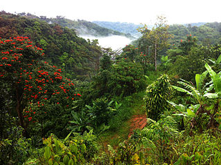
Toro Negro State Forest is one of the 21 forests that make up the public forests system in Puerto Rico. It is also Puerto Rico's highest cloud forest. It is in the Cordillera Central region of the island and covers 8,204 cuerdas, of mountains. Toro Negro's mountains have heights reaching up to 4,400 feet (1,300 m) and include Cerro de Punta, Cerro Jayuya and Cerro Rosa, the three highest peaks in the island. Nested among these mountains is Lake Guineo, the island's highest lake. The forest has 18 kilometers (11 mi) of trails, an observation tower, two natural swimming pools (Spanish:"charcos"), camping and picnic areas, nine rivers, and numerous creeks and waterfalls. The forest spans areas within the municipalities of Ponce, Jayuya, Orocovis, Ciales, and Juana Díaz, and consists of seven non-contiguous tracts of land. The largest contiguous segment of the forest is located in the municipalities of Ponce and Jayuya. Some 40% of the area of Toro Negro State Forest is located in Ponce's Barrio Anón.

Anón is one of the 31 barrios in the municipality of Ponce, Puerto Rico. Along with Marueño, Coto Laurel, Guaraguao, Quebrada Limon, Real, and San Patricio, and the coastal barrios of Canas and Capitanejo, Anón is one of the municipality's nine bordering barrios. Anón borders the municipalities of Jayuya and Juana Diaz. The name of this barrio is of native Indian origin. It was founded in 1878. Barrio Anón is one of three Ponce barrios located on the Cordillera Central mountain range.

Tibes is one of the 31 barrios in the municipality of Ponce, Puerto Rico. Together with Magueyes, Portugués, Montes Llanos, Maragüez, Machuelo Arriba, Sabanetas, and Cerrillos, barrio Tibes is one of the municipality's eight rural interior barrios. Tibes attracted attention recently when, in 1975, what was to become the discovery of the oldest cemetery in the West Indies came about as a result of rainstorms. The name of this barrio is of native Indian origin. It was organized in 1831.
Duey is a barrio in the municipality of Yauco, Puerto Rico. Its population in 2010 was 1,108.

Cerro del Vigía is a hill in the municipality of Ponce, Puerto Rico, located just north of the city of Ponce. A tourist destination, it is home to Museo Castillo Serrallés, Cruceta del Vigía, and the former Hotel Ponce Intercontinental.

Cerro del Diablo is a mountain in the municipality of Ponce, Puerto Rico, located north-northwest of the city of Ponce. The 2,234-foot high hill sits at the foothills of the Cordillera Central and is located in Barrio Tibes.

Carite State Forest is a state forest and nature reserve located in the Sierra de Cayey mountain range in southeastern Puerto Rico. The forest extends over approximately 6,500 acres and is located in the municipalities of Caguas, Cayey, Guayama, Patillas and San Lorenzo. The forest is located along the Ruta Panorámica, which offers access to the forest.

Guilarte State Forest is one of the 20 forests that make up the public forests system in Puerto Rico. The forest is located in the eastern half of the Central Mountain Range or Cordillera Central. The main geographical feature of the forest reserve is Monte Guilarte, which is Puerto Rico's 7th highest mountain at 3,950 feet above sea level. While Monte Guilarte is located in the municipality of Adjuntas, the forest's borders also include parts of Guayanilla, Peñuelas and Yauco.

Lake Luchetti is a reservoir located in the municipality of Yauco, Puerto Rico, in the barrios of Naranjo and Vegas. The lake was formerly known as the Vegas Lake after the barrio it is located in. The lake was created at the junction of the Naranjo River and some minor streams with the Yauco River under Puerto Rico Electric Power Authority's (PREPA) Yauco Project in 1959 and revitalized for further hydroelectric use in 1991. The lake is named after Antonio S. Luchetti, a Puerto Rican engineer who was vital in the development of the hydroelectrical energy system in Puerto Rico.

