Elbow Lake, Grant County, Minnesota

Last updated

Elbow Lake
Elbow Lake, Minnesota 01.jpg
Central Avenue North in Elbow Lake
Grant County Minnesota Incorporated and Unincorporated areas Elbow Lake Highlighted.svg
Location of Elbow Lake
within Grant County, Minnesota
Coordinates: 45°59′39″N95°58′36″W / 45.99417°N 95.97667°W / 45.99417; -95.97667
CountryUnited States
State Minnesota
County Grant
Founded1886
IncorporatedAugust 30, 1887
Government
   Mayor Deb Hengel
Area
[1]
  Total1.76 sq mi (4.55 km2)
  Land1.38 sq mi (3.58 km2)
  Water0.37 sq mi (0.97 km2)
Elevation
1,220 ft (372 m)
Population
 (2020) [2]
  Total1,276
  Estimate 
(2022) [3]
1,284
  Density921.97/sq mi (355.93/km2)
Time zone UTC-6 (Central)
  Summer (DST) UTC-5 (CDT)
ZIP code
56531
Area code 218
FIPS code 27-18458 [4]
GNIS feature ID0643230 [5]
Website thecityofelbowlake.com

Elbow Lake is a city and county seat of Grant County, Minnesota, United States. [6] The population was 1,276 at the 2020 census. [2]

Contents

History

Grant County Courthouse Grant County Courthouse 2012.jpg
Grant County Courthouse

Elbow Lake was platted in 1886. [7] The city took its name from nearby Elbow Lake. [7]

Geography

According to the United States Census Bureau, the city has an area of 1.34 square miles (3.47 km2), all land. [8]

U.S. Highway 59 and Minnesota State Highways 55 and 79 are four of the main routes in the city. Elbow Lake is 12 miles west of Interstate Highway 94.

Elbow Lake is in telephone area code 218.

Demographics

Historical population
CensusPop.Note
1890 267
1900 625134.1%
1910 77624.2%
1920 86711.7%
1930 9034.2%
1940 1,15027.4%
1950 1,39821.6%
1960 1,5218.8%
1970 1,484−2.4%
1980 1,358−8.5%
1990 1,186−12.7%
2000 1,2757.5%
2010 1,176−7.8%
2020 1,2768.5%
2022 (est.)1,284 [3] 0.6%
U.S. Decennial Census [9]
2020 Census [2]

2010 census

As of the census of 2010, there were 1,176 people, 538 households, and 313 families residing in the city. The population density was 877.6 inhabitants per square mile (338.8/km2). There were 623 housing units at an average density of 464.9 per square mile (179.5/km2). The racial makeup of the city was 97.4% White, 0.2% African American, 0.3% Native American, 0.2% Asian, 0.3% from other races, and 1.7% from two or more races. Hispanic or Latino of any race were 1.2% of the population.

There were 538 households, of which 27.7% had children under the age of 18 living with them, 44.8% were married couples living together, 9.9% had a female householder with no husband present, 3.5% had a male householder with no wife present, and 41.8% were non-families. 37.9% of all households were made up of individuals, and 19% had someone living alone who was 65 years of age or older. The average household size was 2.16 and the average family size was 2.86.

The median age in the city was 40.9 years. 24.1% of residents were under the age of 18; 5.8% were between the ages of 18 and 24; 24.3% were from 25 to 44; 26.9% were from 45 to 64, and 18.9% were 65 years of age or older. The gender makeup of the city was 45.1% male and 54.9% female.

2000 census

As of the census of 2000, there were 1,275 people, 560 households, and 348 families residing in the city. The population density was 944.9 inhabitants per square mile (364.8/km2). There were 624 housing units at an average density of 462.5 per square mile (178.6/km2). The racial makeup of the city was 97.41% White, 0.24% Native American, 0.47% Asian, 0.78% from other races, and 1.10% from two or more races. Hispanic or Latino of any race were 1.33% of the population.

There were 560 households, out of which 27.9% had children under the age of 18 living with them, 51.6% were married couples living together, 8.8% had a female householder with no husband present, and 37.7% were non-families. 33.9% of all households were made up of individuals, and 23.6% had someone living alone who was 65 years of age or older. The average household size was 2.26 and the average family size was 2.93.

In the city, the population was spread out, with 24.9% under the age of 18, 7.8% from 18 to 24, 25.2% from 25 to 44, 17.4% from 45 to 64, and 24.7% who were 65 years of age or older. The median age was 40 years. For every 100 females, there were 84.5 males. For every 100 females age 18 and over, there were 82.5 males.

The median income for a household in the city was $30,441, and the median income for a family was $38,611. Males had a median income of $28,839 versus $20,515 for females. The per capita income for the city was $16,429. About 6.3% of families and 7.7% of the population were below the poverty line, including 10.7% of those under age 18 and 6.2% of those age 65 or over.

Education

Elbow Lake is part of the West Central Area School system, which includes Barrett, Hoffman, Kensington, Wendell, and many other communities. Elementary school facilities are in Elbow Lake and Kensington, and the secondary school, which opened in 1995, is in Barrett, seven miles from Elbow Lake.

Parks

Elbow Lake has several parks within city limits that offer a variety of recreational opportunities, including softball fields, a volleyball court, lighted tennis courts, an ice skating rink with a warming house, a running track, playground equipment, picnic shelters, and a bandshell for summer entertainment.

The Tipsinah Mounds Campground and park, four miles east of Elbow Lake on Pomme de Terre Lake, has a public swimming beach, playground equipment, hiking and nature trails, and an above-ground tornado shelter. Fairhaven Beach, on Pomme de Terre Lake, is a public swimming beach.

Libraries

Thorson Memorial Public Library [10] is in Elbow Lake. It is Grant County's only library. It is in the Scofield Memorial Building, [11] built in 1933 with funding from the Public Works Administration (PWA) and donated funds. The building was placed on the National Register of Historic Places in 2016.

Thorson Memorial Library is a member of Viking Library Regional Library System. [12]

Related Research Articles

<span class="mw-page-title-main">Grant County, Minnesota</span> County in Minnesota, United States

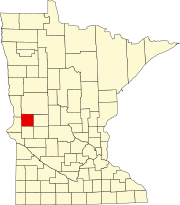
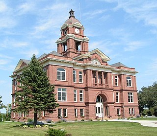
Grant County is a county in the U.S. state of Minnesota. As of the 2020 census, the population was 6,074. Its county seat is Elbow Lake.

<span class="mw-page-title-main">Clinton, Kentucky</span> City in Kentucky, United States

Clinton is a home rule-class city and the county seat of Hickman County, Kentucky, United States. The population was 1,388 at the 2010 census, a decline from 1,415 in 2000.

Eagle View Township is a township in Becker County, Minnesota, United States. The population was 165 as of the 2000 census.

Round Lake Township is a township in Becker County, Minnesota, United States. The population was 157 as of the 2000 census.

<span class="mw-page-title-main">Lake Shore, Minnesota</span> City in Minnesota, United States

Lake Shore is a city in Cass County, Minnesota, United States. The population was 1,056 at the 2020 census. It is part of the Brainerd Micropolitan Statistical Area.

Ponto Lake Township is a township in Cass County, Minnesota, United States. The population was 530 as of the 2000 census. The etymology of the name Ponto is obscure.

<span class="mw-page-title-main">Barrett, Minnesota</span> City in Minnesota, United States

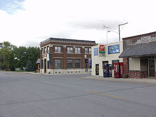
Barrett is a city in Grant County, Minnesota, United States. The population was 415 at the 2010 census.

Elbow Lake Township is a township in Grant County, Minnesota, United States. The population was 157 at the 2000 census.

<span class="mw-page-title-main">Wendell, Minnesota</span> City in Minnesota, United States

Wendell is a city in Grant County, Minnesota, United States. The population was 167 at the 2010 census.

<span class="mw-page-title-main">Lastrup, Minnesota</span> City in Minnesota, United States

Lastrup is a city in Morrison County, Minnesota, United States. The population was 120 at the 2020 census.

<span class="mw-page-title-main">Le Roy, Minnesota</span> City in Minnesota, United States

Le Roy is a city in Mower County, Minnesota, United States, surrounded by Le Roy Township. The population was 957 at the 2020 census. Lake Louise State Park is just outside the town.

<span class="mw-page-title-main">Hadley, Minnesota</span> City in Minnesota, United States

Hadley is a city in Murray County, Minnesota, United States. The population was 54 at the 2020 census.

Beatty Township is a township in Saint Louis County, Minnesota, United States. Beatty Township bears the name of a family of pioneer settlers. The population was 372 at the 2010 census.

Clinton Township is a township in Saint Louis County, Minnesota, United States. Clinton Township was named for Clinton Markell, a prominent settler. The population was 1,015 at the 2010 census.

<span class="mw-page-title-main">Winton, Minnesota</span> City in Minnesota, United States

Winton is a city in Saint Louis County, Minnesota, United States. The population was 172 at the 2010 census. The city is home to a small hydroelectric dam on the edge of Garden Lake, one of 11 stations owned by Minnesota Power.

<span class="mw-page-title-main">Landfall, Minnesota</span> City in Minnesota, United States

Landfall is a city in Washington County, Minnesota, United States. The population was 686 at the 2010 census and is the smallest community in Washington County in terms of area. It lies on the eastern shore of Tanner's Lake on Interstate 94.

<span class="mw-page-title-main">Maple Lake, Minnesota</span> City in Minnesota, United States

Maple Lake is a city in Wright County, Minnesota, United States. The population was 2,159 at the 2020 census. Minnesota State Highway 55 serves as a main route in the city.

<span class="mw-page-title-main">Ortonville, Minnesota</span> City in Minnesota, United States

Ortonville is a city and the county seat of Big Stone County in the U.S. state of Minnesota at the southern tip of Big Stone Lake, along the border with South Dakota. The population was 2,021 at the 2020 census. Big Stone Lake State Park is nearby.

<span class="mw-page-title-main">Minnesota Lake, Minnesota</span> City in Minnesota, United States

Minnesota Lake is a city in Blue Earth and Faribault counties in the State of Minnesota. The population was 661 at the 2020 census. The bulk of the city is in Faribault County; a small part extends into Blue Earth County.

<span class="mw-page-title-main">Elbow Lake, Becker County, Minnesota</span> Census-designated place in Minnesota, US

Elbow Lake is a census-designated place in Becker and Clearwater counties in Minnesota, United States. Its population was 95 at the 2010 census.

References

  1. "2020 U.S. Gazetteer Files". United States Census Bureau. Retrieved July 24, 2022.
  2. 1 2 3 "Explore Census Data". United States Census Bureau . Retrieved April 26, 2023.
  3. 1 2 "City and Town Population Totals: 2020-2022". United States Census Bureau. June 25, 2023. Retrieved June 25, 2023.
  4. "U.S. Census website". United States Census Bureau . Retrieved January 31, 2008.
  5. "US Board on Geographic Names". United States Geological Survey. October 25, 2007. Retrieved January 31, 2008.
  6. "Find a County". National Association of Counties. Archived from the original on July 12, 2012. Retrieved June 7, 2011.
  7. 1 2 Upham, Warren (1920). Minnesota Geographic Names: Their Origin and Historic Significance. Minnesota Historical Society. p.  214.
  8. "US Gazetteer files 2010". United States Census Bureau. Archived from the original on January 25, 2012. Retrieved November 13, 2012.
  9. United States Census Bureau. "Census of Population and Housing" . Retrieved September 11, 2013.
  10. "Elbow Lake Public Library". Elbow Lake Public Library. Retrieved August 2, 2016.
  11. National Register of Historic Places listings in Minnesota
  12. "Viking Library System". Viking Library System. Retrieved August 2, 2016.

Commons-logo.svg Media related to Elbow Lake, Grant County, Minnesota at Wikimedia Commons

45°59′39″N95°58′36″W / 45.99417°N 95.97667°W / 45.99417; -95.97667