Related Research Articles

Electoral districts of Victoria are the electoral districts, commonly referred to as "seats" or "electorates", into which the Australian State of Victoria is divided for the purpose of electing members of the Victorian Legislative Assembly, one of the two houses of the Parliament of the State. The State is divided into 88 single-member districts. The Legislative Assembly has had 88 electorates since the 1985 election, increased from 81 previously.
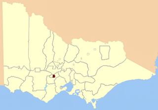
Ballarat East was an electoral district of the Legislative Assembly in the Australian state of Victoria. Prior to its abolition, it was a 3,323 km² part-urban and part-rural electorate covering areas to the east of the regional centre of Ballarat. It included the Ballarat suburbs of Ballarat East, Bakery Hill, Golden Point, Eureka, Canadian, Mount Pleasant, Mount Clear, Mount Helen and Warrenheip, and the rural towns of Ballan, Buninyong, Bungaree, Creswick, Daylesford, Dunnstown, Hepburn Springs, Kyneton, Lal Lal, Malmsbury, Meredith and Steiglitz. The electorate had a population of 54,127 as of the 2006 census, with 40,578 enrolled electors at the 2010 state election.
The Electoral district of Doncaster was a metropolitan electorate of the Victorian Legislative Assembly, located approximately 13 kilometres north-east of Melbourne. It was part of the Upper House Eastern Metropolitan Region and sat entirely within the City of Manningham. It was abolished and divided between the Electoral district of Bulleen and the Electoral district of Warrandyte The seat was abolished due to new boundary changes in preparation for the 2014 election.
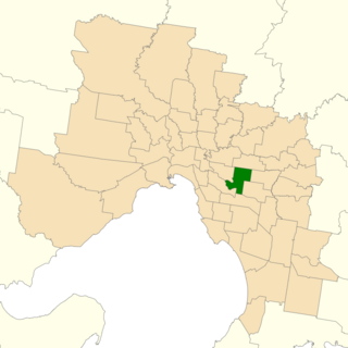
The electoral district of Burwood is an electorate for the Victorian Legislative Assembly in Australia. It is located approximately 13 kilometres east of Melbourne, and covers an area of 25 km2. It includes the suburbs of Ashburton, Ashwood, Box Hill South, Burwood, and parts of Camberwell, Chadstone, Glen Iris, and Surrey Hills. It was created in 1955 as part of the expansion of the Legislative Assembly, and abolished in 1967, replaced by Glen Iris. It was recreated in 1976, replacing Glen Iris.

The Electoral district of Rodney was a Victorian Legislative Assembly electorate in Northern Victoria.

The electoral district of Albert Park is one of the electoral districts of Victoria, Australia, for the Victorian Legislative Assembly. It covers an area of 22 square kilometres (8.5 sq mi) in inner suburban Melbourne, and includes the suburbs of Albert Park, Middle Park, Port Melbourne, St Kilda West, Southbank, South Melbourne, South Wharf, and parts of St Kilda. It lies within the Southern Metropolitan Region of the upper house, the Legislative Council.

The Electoral district of Ballarat West was an electoral district of the Victorian Legislative Assembly in Australia. It existed from 1859–1927 and from 1992–2014.

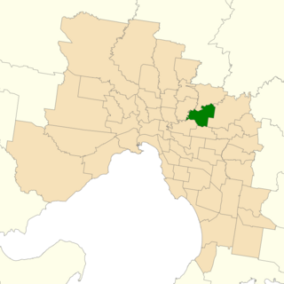
The electoral district of Bayswater is one of the electoral districts of Victoria, Australia, for the Victorian Legislative Assembly. It covers an area of 40 square kilometres (15 sq mi) in outer eastern Melbourne, and includes the suburbs of Bayswater, Heathmont, Kilsyth South and The Basin, and parts of Bayswater North, Boronia, Ringwood and Wantirna. It lies within the Eastern Metropolitan Region of the upper house, the Legislative Council.

The electoral district of Yan Yean is an electoral district of the Victorian Legislative Assembly. It is located on the fringes of Melbourne's northern suburbs and contains the towns of Hurstbridge, Plenty, Whittlesea and Yan Yean.

The electoral district of Thomastown is an electorate of the Victorian Legislative Assembly. It currently includes the suburbs of Lalor and Thomastown, and parts of Fawkner, Reservoir and Wollert, and has been in existence since 1985.
The Electoral district of Clayton is a former electoral district of the Victorian Legislative Assembly. It was named for the Melbourne suburb of Clayton, and also includes Clarinda, Notting Hill as well as parts of surrounding suburbs.
Derrimut was an electoral district of the Victorian Legislative Assembly. It was located in the western suburbs of Melbourne and contained the suburbs of Albion, Derrimut as well as parts of St Albans and Sunshine.

The electoral district of Niddrie is a metropolitan electorate approximately 8 kilometres (5 mi) northwest of Melbourne, Australia in Victoria's Legislative Assembly.

The electoral district of Broadmeadows is an electorate of the Victorian Legislative Assembly. It covers an area of 49 square kilometres (19 sq mi) in outer northern Melbourne, and includes the suburbs of Broadmeadows, Campbellfield, Coolaroo, Dallas, Fawkner, Jacana and Meadow Heights. It also includes parts of Glenroy, Roxburgh Park, Somerton and Westmeadows. It lies within the Northern Metropolitan Region of the upper house, the Legislative Council.
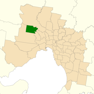
The electoral district of Bulleen is an electoral district of the Victorian Legislative Assembly. It covers an area of 36 square kilometres (14 sq mi) in eastern Melbourne, including the suburbs of Bulleen, Doncaster, Templestowe Lower, and part of Templestowe. It lies within the Eastern Metropolitan Region of the upper house, the Legislative Council.
Kilsyth was an electoral district of the Legislative Assembly in the Australian state of Victoria. It was a 41 km² electorate located in the outer eastern suburbs of Melbourne, encompassing the suburbs of Bayswater North and Croydon South and parts of the suburbs of Kilsyth, Lilydale and Montrose. The electorate had a population of 52,701 at the 2001 census.

The electoral district of Bellarine is one of the electoral districts of Victoria, Australia, for the Victorian Legislative Assembly. It covers an area of 367 square kilometres (142 sq mi) stretching from the Bellarine Peninsula to the outer eastern suburbs of Geelong. It includes the towns of Barwon Heads, Clifton Springs, Drysdale, Indented Head, Ocean Grove, Point Lonsdale, Portarlington and Queenscliff and the Geelong suburbs of Leopold and Moolap. It lies within the Western Victoria Region of the upper house, the Legislative Council.

Natalie Maree Hutchins, also known as Natalie Sykes-Hutchins, is an Australian politician. She has been a Labor Party member of the Victorian Legislative Assembly since 2010, representing the electorates of Keilor (2010–2014) and Sydenham (2014–present). She was Minister for Local Government, Minister for Aboriginal Affairs and Minister for Industrial Relations in the First Andrews Ministry from December 2014 to December 2018. In June 2020, she rejoined the cabinet as Minister for Victim Support and Minister for Corrections, Youth Justice and Crime Prevention.
The electoral district of Sydenham is an electoral district of the Victorian Legislative Assembly in Australia. It was created in the redistribution of electoral boundaries in 2013, and came into effect at the 2014 state election.

The Division of Fraser is an Australian electoral division in the state of Victoria, which was contested for the first time at the 2019 federal election.
References
- ↑ "Re-Member (Former Members)". State Government of Victoria. Retrieved 29 May 2014.
| | This Victoria (Australia) government-related article is a stub. You can help Wikipedia by expanding it. |