Related Research Articles
Politics of the Australian state of Victoria takes place in the context of a constitutional monarchy with a bicameral parliamentary system, and like other Australian states, Victoria is part of the federation known as the Commonwealth of Australia.
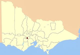
Ballarat East was an electoral district of the Legislative Assembly in the Australian state of Victoria. Prior to its abolition, it was a 3,323 km² part-urban and part-rural electorate covering areas to the east of the regional centre of Ballarat. It included the Ballarat suburbs of Ballarat East, Bakery Hill, Golden Point, Eureka, Canadian, Mount Pleasant, Mount Clear, Mount Helen and Warrenheip, and the rural towns of Ballan, Buninyong, Bungaree, Creswick, Daylesford, Dunnstown, Hepburn Springs, Kyneton, Lal Lal, Malmsbury, Meredith and Steiglitz. The electorate had a population of 54,127 as of the 2006 census, with 40,578 enrolled electors at the 2010 state election.
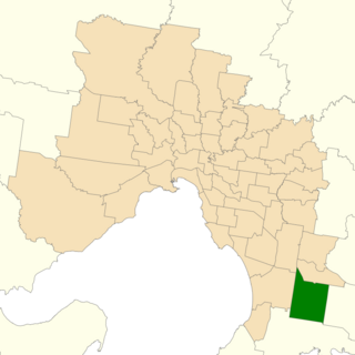
Cranbourne is an electoral district of the Victorian Legislative Assembly. It is located south-east of Melbourne and includes the suburbs of Botanic Ridge, Cranbourne, Cranbourne East, Cranbourne North, Cranbourne West, Junction Village, as well as parts of Clyde, Clyde North, Cranbourne South, Devon Meadows, Lynbrook and Lyndhurst. It was created prior to the 1992 state election.

The electoral district of Bass is one of the electoral districts of Victoria, Australia, for the Victorian Legislative Assembly. It covers an area of 1,383 square kilometres (534 sq mi) south east of Melbourne, stretching from outer suburban Pakenham through rural areas to the coast at Inverloch and Phillip Island. It includes the towns of Bass, Cape Paterson, Corinella, Cowes, Grantville, Inverloch, Kilcunda, Koo Wee Rup, Lang Lang, Rhyll, San Remo, Ventnor, Wonthaggi, and part of suburban Pakenham. It lies within the Eastern Victoria Region of the upper house, the Legislative Council.

The electoral district of Bayswater is one of the electoral districts of Victoria, Australia, for the Victorian Legislative Assembly. It covers an area of 40 square kilometres (15 sq mi) in outer eastern Melbourne, and includes the suburbs of Bayswater, Heathmont, Kilsyth South and The Basin, and parts of Bayswater North, Boronia, Ringwood and Wantirna. It lies within the Eastern Metropolitan Region of the upper house, the Legislative Council.

The electoral district of Essendon is an electoral district of the Victorian Legislative Assembly. It was first created in 1904 after the abolition of the larger Essendon and Flemington electorate, and covers some of the north-western suburbs of Melbourne, including Essendon, Moonee Ponds and Ascot Vale.

The electoral district of Eltham is an electoral district of the Victorian Legislative Assembly. It is an outer metropolitan electorate and contains Eltham, Lower Plenty as well as parts of Greensborough and Kangaroo Ground.

The electoral district of Yan Yean is an electoral district of the Victorian Legislative Assembly. It is located on the fringes of Melbourne's northern suburbs and contains the towns of Hurstbridge, Plenty, Whittlesea and Yan Yean.

The electoral district of Thomastown is an electorate of the Victorian Legislative Assembly. It currently includes the suburbs of Lalor and Thomastown, and parts of Fawkner, Reservoir and Wollert, and has been in existence since 1985.
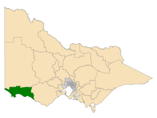
The electoral district of South-West Coast is an electorate of the Victorian Legislative Assembly. It was created prior to the 2002 election in order to replace the abolished seats of Portland and Warrnambool.

The electoral district of Frankston is an electoral district of the Victorian Legislative Assembly. It currently includes the suburbs of Frankston and Frankston South south east of Melbourne.

The electoral district of Kororoit is an electorate of the Victorian Legislative Assembly covering Albanvale, Caroline Springs as well as some parts of Deer Park and St Albans in the western suburbs of Melbourne.

The electoral district of Warrandyte is an Australian electoral district of the Victorian Legislative Assembly. It is an outer metropolitan electorate and contains Warrandyte, Warranwood as well as parts of Croydon and Ringwood.
The Electoral district of Clayton is a former electoral district of the Victorian Legislative Assembly. It was named for the Melbourne suburb of Clayton, and also includes Clarinda, Notting Hill as well as parts of surrounding suburbs.
Derrimut was an electoral district of the Victorian Legislative Assembly. It was located in the western suburbs of Melbourne and contained the suburbs of Albion, Derrimut as well as parts of St Albans and Sunshine.
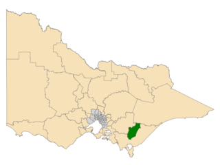
The electoral district of Morwell is an electoral district of the Victorian Legislative Assembly. It covers the regional centres of Morwell and Traralgon as well as the surrounding rural areas in the middle of Gippsland.

South Barwon is an electoral district of the Legislative Assembly in the Australian state of Victoria. Located in a mixed urban and rural area south of the Barwon River, it covers an area of 621 km², including the Geelong suburbs of Belmont and Grovedale, Waurn Ponds and part of Highton, the coastal centre of Torquay and the rural towns of Barrabool, Bellbrae, Connewarre, Gnarwarre, Modewarre, Moriac and Mount Moriac. The electorate had a population of 52,241 at the 2001 census.

The electoral district of Broadmeadows is an electorate of the Victorian Legislative Assembly. It covers an area of 49 square kilometres (19 sq mi) in outer northern Melbourne, and includes the suburbs of Broadmeadows, Campbellfield, Coolaroo, Dallas, Fawkner, Jacana and Meadow Heights. It also includes parts of Glenroy, Roxburgh Park, Somerton and Westmeadows. It lies within the Northern Metropolitan Region of the upper house, the Legislative Council.

Bendigo West is an electoral district of the Legislative Assembly in the Australian state of Victoria. It is a 1,524 square kilometres (588 sq mi) electorate centred on the city of Bendigo west of the Yungera railway line, and including surrounding rural towns to the west and south-west. It encompasses the localities of Bendigo City, California Gully, Castlemaine, Harcourt, Long Gully, Maldon, Marong, Newstead and West Bendigo. It also includes parts of the Bendigo suburbs of Eaglehawk, Golden Square and Kangaroo Flat. It lies within the Northern Victoria Region of the upper house, the Legislative Council.
Benedict (Ben) Paul Hardman is an Australian politician. He was a Labor Party member of the Victorian Legislative Assembly from 1999 to 2010, representing the electorate of Seymour.
References
- ↑ "Re-Member (Former Members)". State Government of Victoria. Retrieved 29 May 2014.
| | This Victoria (Australia) government-related article is a stub. You can help Wikipedia by expanding it. |