Eleva, Wisconsin

Last updated

Eleva, Wisconsin
Eleva, Wisconsin.jpg
Trempealeau County Wisconsin Incorporated and Unincorporated areas Eleva Highlighted.svg
Location of Eleva in Trempealeau County, Wisconsin.
Coordinates: 44°34′31″N91°28′16″W / 44.57528°N 91.47111°W / 44.57528; -91.47111
Country Flag of the United States.svg  United States
State Flag of Wisconsin.svg  Wisconsin
County Trempealeau
Area
[1]
  Total0.58 sq mi (1.50 km2)
  Land0.56 sq mi (1.46 km2)
  Water0.02 sq mi (0.04 km2)
Elevation
[2]
863 ft (263 m)
Population
 (2020) [3]
  Total685
  Density1,266.51/sq mi (489/km2)
Time zone UTC−6 (Central (CST))
  Summer (DST) UTC−5 (CDT)
ZIP Code
54738
Area code(s) 715 & 534
FIPS code 55-23175 [4]
GNIS feature ID1564504 [2]

Eleva is a village within the Town of Albion in Trempealeau County, Wisconsin, along the Buffalo River. The population was 670 at the 2010 Census and reached 685 in the 2020 Census.

Contents

History

Before white settlement, Lakota and Ho-Chunk Indians controlled the area that would become Eleva, but Ojibwe territory lay only ten miles north, across the Chippewa River. The first settlers in what would become the town of Albion arrived in 1856. Most settled east of the future Eleva, around what would be called Hamlin, on the stage road from Whitehall to Eau Claire. In these early days some Indians still migrated through in the spring and fall, camping just west of where Eleva would grow. William Moon, one of the first settlers, harvested potatoes that first fall of 1856 - the first harvest in Albion. In following years more settlers arrived, and began growing wheat and corn. [5]

The first building in what would become Eleva was constructed in 1863, when Joseph and Elizabeth Cooper built a cabin of tamarack logs near Big Creek. They left when Joseph volunteered in the Union Army, but returned to their cabin after the war. David J. O'dell settled nearby in 1867. [5]

In 1876 John Redford and Marsh Goddard arrived, starting a combination general store and blacksmith shop. Goddard hauled most of his goods by horse and wagon from the train station in Augusta. That same year, Philo Englesby built a hotel. The following year E.J. Carpenter started a grist mill on Big Creek which ground wheat between two big flat stones. That year the community added a second general store, a hardware store, a drug store, a confectionery, a meat shop, and a boarding house. Perhaps because the community was growing so fast, an 1877 map labelled it "New Chicago." [5]

The village was platted in 1877. The source of the name "Eleva" has long been debated, with these possible origins:

  1. Some say "Eleva" is how Indians pronounced "I leave you" when they left.
  2. Some say it was named after a place in Ireland.
  3. Some say that "ELEVA" was painted on a grain elevator, and then winter struck before the painter could finish "TOR". Newcomers assumed the letters were the name of the village. [6]
  4. Some say the town was named after a French village by Goddard, who was from France.
  5. Some say it was named for Goddard's daughter Eva, who died young. [5]

The community's first school was built in 1885, but it was two miles east, called Grant School for the farmer who rented the school land. This Grant was also the chairman of the school district, and a second cousin of President Ulysses S. Grant. [5] A post office called Eleva started operation in one of the town's stores the same year. [7]

In 1889 Nathaniel Foster's Fairchild and Mississippi Railroad reached Eleva, following the Buffalo (then Beef) River. Foster added a lumber yard in Eleva and the railroad built a depot in 1890. A few years later Foster's railroad was acquired by the Chicago, St. Paul, Minneapolis and Omaha Railway. [5]

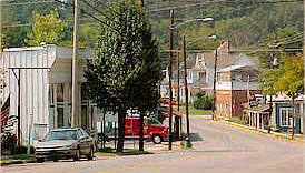
In 1890 Henry Ruseling replaced his old stone grist mill with the modern-for-the-time Eleva Roller Mills, powered by water or coal, producing 50 barrels of wheat per day. That year, the town built its own school in town, serving grades one through eight. The town was booming, with two elevators, a cheese factory, a flour and feed mill, a hardware store, a drug store, a printer, a photographer, a tailor, a shoemaker, two plumbers, two blacksmiths, a doctor, an implement dealer, two hay buyers, and two livestock dealers. The town had no saloons. With all these services in Eleva and the railroad bypassing Hamlin two miles to the east, Hamlin gradually dried up. [5]

In 1901 the Osseo Telephone Company opened an exchange in Eleva. In 1902 Eleva incorporated as a village, with population around 314. That same year, Eleva replaced its 1890 school with a new brick school that taught grades one through ten, making it a state-graded school. The following year the Bank of Eleva was organized. [5]

In 1914 the village began to furnish electric service. At first the electricity was on only in the evenings, with extended hours on Tuesdays so the women could do their ironing. [5]

In 1917, Eleva's school became a high school, running through grade twelve. That served the community until 1950, when the shared Eleva-Strum high school was built midway between the two towns. Eleva itself built a new grade school in 1960. [5]

Geography

Eleva is located at 44°34′31″N91°28′16″W / 44.57528°N 91.47111°W / 44.57528; -91.47111 (44.575298, −91.471019). [8]

According to the United States Census Bureau, the village has a total area of 0.60 square miles (1.55 km2), of which, 0.58 square miles (1.50 km2) of it is land and 0.02 square miles (0.05 km2) is water. [9]

Demographics

Historical population
CensusPop.Note
1910 319
1920 37918.8%
1930 357−5.8%
1940 40613.7%
1950 47918.0%
1960 54814.4%
1970 5744.7%
1980 5933.3%
1990 491−17.2%
2000 63529.3%
2010 6705.5%
2020 6852.2%
U.S. Decennial Census [10]

2010 census

As of the census [3] of 2010, there were 670 people, 292 households, and 181 families living in the village. The population density was 1,155.2 inhabitants per square mile (446.0/km2). There were 305 housing units at an average density of 525.9 per square mile (203.1/km2). The racial makeup of the village was 97.9% White, 0.1% Native American, 0.3% Asian, 0.7% from other races, and 0.9% from two or more races. Hispanic or Latino of any race were 1.3% of the population.

There were 292 households, of which 33.6% had children under the age of 18 living with them, 44.2% were married couples living together, 11.6% had a female householder with no husband present, 6.2% had a male householder with no wife present, and 38.0% were non-families. Of all households, 31.2% were made up of individuals, and 16.8% had someone living alone who was 65 years of age or older. The average household size was 2.29 and the average family size was 2.86.

The median age in the village was 39.5 years. 24.5% of residents were under the age of 18; 8.1% were between the ages of 18 and 24; 26% were from 25 to 44; 23.9% were from 45 to 64; and 17.6% were 65 years of age or older. The gender makeup of the village was 48.7% male and 51.3% female.

2000 census

As of the census [4] of 2000, there were 635 people, 277 households, and 175 families living in the village. The population density was 1,169.0 people per square mile (454.0/km2). There were 290 housing units at an average density of 533.9 per square mile (207.4/km2). The racial makeup of the village was 98.43% White, 0.16% African American, 0.16% Native American, 0.16% Asian, and 1.10% from two or more races.

There were 277 households, out of which 26.7% had children under the age of 18 living with them, 49.5% were married couples living together, 9.4% had a female householder with no husband present, and 36.8% were non-families. Of all households, 33.9% were made up of individuals, and 15.9% had someone living alone who was 65 years of age or older. The average household size was 2.29 and the average family size was 2.89.

In the village, the population was spread out, with 23.5% under the age of 18, 7.1% from 18 to 24, 28.7% from 25 to 44, 21.3% from 45 to 64, and 19.5% who were 65 years of age or older. The median age was 38 years. For every 100 females, there were 98.4 males. For every 100 females age 18 and over, there were 92.1 males.

The median income for a household in the village was $31,250, and the median income for a family was $41,964. Males had a median income of $30,294 versus $21,618 for females. The per capita income for the village was $15,814. About 5.6% of families and 9.5% of the population were below the poverty line, including 11.6% of those under age 18 and 8.1% of those age 65 or over.

Related Research Articles

<span class="mw-page-title-main">Springville, Alabama</span> City in Alabama, United States

Springville is a city in St. Clair County, Alabama, United States. It incorporated in December 1880. At the 2020 census the population was 4,786, up from 4,080 in 2010.

<span class="mw-page-title-main">Buncombe, Illinois</span> Village in Illinois, United States

Buncombe is a village in Johnson County, Illinois, United States. The population was 203 at the 2010 census and as of 2018, the population had declined to an estimated 173.

<span class="mw-page-title-main">Trafalgar, Indiana</span> Town in Indiana, United States

Trafalgar is a town in Nineveh and Hensley townships, Johnson County, Indiana, United States. The population was 1,101 at the 2010 census.

<span class="mw-page-title-main">Minot, Maine</span> Town in the state of Maine, United States

Minot is a town in Androscoggin County, Maine, United States. The population was 2,766 at the 2020 census. The town includes the villages of West Minot and Minot Center. It is part of both the Lewiston-Auburn, Maine metropolitan statistical area and the Lewiston-Auburn, Maine metropolitan New England city and town area.

<span class="mw-page-title-main">Caswell, Maine</span> Town in the state of Maine, United States

Caswell is a town in Aroostook County, Maine, United States. The population was 293 at the 2020 census.

<span class="mw-page-title-main">Hamlin, Maine</span> Town in the state of Maine, United States

Hamlin is a town in Aroostook County, Maine, United States. It is located on the Canada–US border with a border crossing into Grand Falls, New Brunswick and is the closest continental location to Europe in the United States. Hamlin's northeastern corner is the closest point in the mainland United States to Western Europe, situated at a distance of 2,508 miles (4,018 km) from the closest point in Europe to the USA, Achill Head. The population was 166 at the 2020 census.

<span class="mw-page-title-main">Appleton, Maine</span> Town in the state of Maine, United States

Appleton is a town in Knox County, Maine, United States. It is about 15 miles inland from Penobscot Bay and coastal towns such as Camden and Rockland, about 30 miles east of the state capital of Augusta. The population was 1,411 at the 2020 census.

<span class="mw-page-title-main">Brookview, Maryland</span> Town in Maryland, United States

Brookview is a town in Dorchester County, Maryland, United States. The population was 48 at the 2020 census. Brookview was incorporated in 1953. Brookview is governed by a three-person town council. Each member of the town council is elected by voters to a three-year term in office. The now deceased Richard E. Sullivan had previously served as mayor of the town since 1996 and was recognized at the 2017 Annual Maryland Municipal League Summer Conference as a long-serving mayor of over 25 years. The 2018 council consisted of Mayor J.D. Hurley, Commissioner Clint Falduto, Commissioner Shelly Hurley. The present 2021 council consists of Mayor Clint Falduto, Commissioner Mary Falduto, Commissioner Shelly Hurley.

<span class="mw-page-title-main">Carsonville, Michigan</span> Village in Michigan, United States

Carsonville is a village in Sanilac County of the U.S. state of Michigan. The population was 527 at the 2010 census. The village is situated at 43°25′37″N82°40′17″W on the boundary between Bridgehampton Township and Washington Township, with about half the village in each.

<span class="mw-page-title-main">Osyka, Mississippi</span> Town in Mississippi, United States

Osyka is a town in Pike County, Mississippi, United States. It is located on the Mississippi–Louisiana state line. The population was 440 at the 2010 census. It is part of the McComb, Mississippi Micropolitan Statistical Area. The peak of its population was in 1910.

<span class="mw-page-title-main">Hamlin, New York</span> Town in New York, United States

Hamlin is a town in Monroe County, New York, United States. The population was 8,725 at the 2020 census.

<span class="mw-page-title-main">Bethesda, Ohio</span> Village in Ohio, United States

Bethesda is a village in west-central Belmont County, Ohio, United States. The population was 1,211 at the 2020 census. It is part of the Wheeling metropolitan area.

<span class="mw-page-title-main">Mingo Junction, Ohio</span> Village in Ohio, United States

Mingo Junction is a village in eastern Jefferson County, Ohio, United States, along the Ohio River. The population was 3,347 at the 2020 census. It is part of the Weirton–Steubenville metropolitan area.

<span class="mw-page-title-main">Commercial Point, Ohio</span> Village in Ohio, United States

Commercial Point is a village in Pickaway County, Ohio, United States. The population was 3,078 at the 2020 census. It is the fastest-growing affluent community in Pickaway County and one of the fastest-growing villages in central Ohio. It is a suburb of Columbus, OH

<span class="mw-page-title-main">Hayti, South Dakota</span> Town in South Dakota, United States

Hayti is a town in and county seat of Hamlin County, South Dakota, United States. The population was 393 at the 2020 census. It is part of the Watertown, South Dakota Micropolitan Statistical Area. It is the county seat of Hamlin County.

<span class="mw-page-title-main">Hamlin, West Virginia</span> Town in West Virginia, United States

Hamlin is a town in and the county seat of Lincoln County, West Virginia, United States, along the Mud River. The population was recorded as 1,040 at the 2020 census. It is part of the Huntington–Ashland metropolitan area.

<span class="mw-page-title-main">West Hamlin, West Virginia</span> Town in West Virginia, United States

West Hamlin is a town in Lincoln County, West Virginia, United States, along the Guyandotte River. The population was 519 at the 2020 census, and is now down to 509, according to the 2021 census. West Hamlin is a part of the Huntington-Ashland, WV-KY-OH, Metropolitan Statistical Area (MSA). West Hamlin is west of the county seat at Hamlin, hence the name.

<span class="mw-page-title-main">West Salem, Wisconsin</span> Village in Wisconsin, United States

West Salem is a village in La Crosse County, Wisconsin, United States, along the La Crosse River. It is part of the La Crosse-Onalaska, WI-MN Metropolitan Statistical Area. The population was 5,277 as of the 2020 census.

<span class="mw-page-title-main">Strum, Wisconsin</span> Village in Wisconsin, United States

Strum is a village in Trempealeau County, Wisconsin, along the Buffalo River. The population was 1,114 at the 2010 census.

<span class="mw-page-title-main">Randolph, Maine</span> Town in the state of Maine, United States

Randolph is a town and a census-designated place (CDP) in Kennebec County, Maine, United States. The population was 1,743 at the 2020 census. The town was named for Randolph, Massachusetts. Randolph is included in the Augusta, Maine micropolitan New England City and Town Area.

References

  1. "2019 U.S. Gazetteer Files". United States Census Bureau. Retrieved August 7, 2020.
  2. 1 2 "US Board on Geographic Names". United States Geological Survey. October 25, 2007. Retrieved January 31, 2008.
  3. 1 2 "U.S. Census website". United States Census Bureau . Retrieved November 18, 2012.
  4. 1 2 "U.S. Census website". United States Census Bureau . Retrieved January 31, 2008.
  5. 1 2 3 4 5 6 7 8 9 10 Fimreite, Clifford (1977). History of Eleva.
  6. Dictionary of Wisconsin History, Source: Osseo News, April 29, 1937; Wisconsin Tales and Trails, Summer 1961, p.32; Retrieved January 28, 2007
  7. "Trempealeau County". Jim Forte Postal History. Archived from the original on April 8, 2015. Retrieved April 3, 2015.
  8. "US Gazetteer files: 2010, 2000, and 1990". United States Census Bureau. February 12, 2011. Retrieved April 23, 2011.
  9. "US Gazetteer files 2010". United States Census Bureau. Archived from the original on January 25, 2012. Retrieved November 18, 2012.
  10. "Census of Population and Housing". Census.gov. Retrieved June 4, 2015.