
Ore is natural rock or sediment that contains one or more valuable minerals concentrated above background levels, typically containing metals, that can be mined, treated and sold at a profit. The grade of ore refers to the concentration of the desired material it contains. The value of the metals or minerals a rock contains must be weighed against the cost of extraction to determine whether it is of sufficiently high grade to be worth mining, and is therefore considered an ore. A complex ore is one containing more than one valuable mineral.
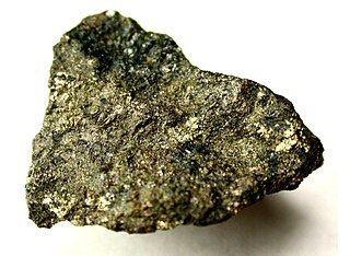
Pentlandite is an iron–nickel sulfide with the chemical formula (Fe,Ni)9S8. Pentlandite has a narrow variation range in nickel to iron ratios (Ni:Fe), but it is usually described as 1:1. In some cases, this ratio is skewed by the presence of pyrrhotite inclusions. It also contains minor cobalt, usually at low levels as a fraction of weight.

Economic geology is concerned with earth materials that can be used for economic and industrial purposes. These materials include precious and base metals, nonmetallic minerals and construction-grade stone. Economic geology is a subdiscipline of the geosciences; according to Lindgren (1933) it is “the application of geology”. It may be called the scientific study of the Earth's sources of mineral raw materials and the practical application of the acquired knowledge.
Skarns or tactites are coarse-grained metamorphic rocks that form by replacement of carbonate-bearing rocks during regional or contact metamorphism and metasomatism. Skarns may form by metamorphic recrystallization of impure carbonate protoliths, bimetasomatic reaction of different lithologies, and infiltration metasomatism by magmatic-hydrothermal fluids. Skarns tend to be rich in calcium-magnesium-iron-manganese-aluminium silicate minerals, which are also referred to as calc-silicate minerals. These minerals form as a result of alteration which occurs when hydrothermal fluids interact with a protolith of either igneous or sedimentary origin. In many cases, skarns are associated with the intrusion of a granitic pluton found in and around faults or shear zones that commonly intrude into a carbonate layer composed of either dolomite or limestone. Skarns can form by regional or contact metamorphism and therefore form in relatively high temperature environments. The hydrothermal fluids associated with the metasomatic processes can originate from a variety of sources; magmatic, metamorphic, meteoric, marine, or even a mix of these. The resulting skarn may consist of a variety of different minerals which are highly dependent on both the original composition of the hydrothermal fluid and the original composition of the protolith.
Volcanogenic massive sulfide ore deposits, also known as VMS ore deposits, are a type of metal sulfide ore deposit, mainly copper-zinc which are associated with and created by volcanic-associated hydrothermal events in submarine environments.

The Southeast Missouri Lead District, commonly called the Lead Belt, is a lead mining district in the southeastern part of Missouri. Counties in the Lead Belt include Saint Francois, Crawford, Dent, Iron, Madison, Reynolds, and Washington. This mining district is the most important and critical lead producer in the United States.
Various theories of ore genesis explain how the various types of mineral deposits form within Earth's crust. Ore-genesis theories vary depending on the mineral or commodity examined.

Sedimentary exhalative deposits are zinc-lead deposits originally interpreted to have been formed by discharge of metal-bearing basinal fluids onto the seafloor resulting in the precipitation of mainly stratiform ore, often with thin laminations of sulphide minerals. SEDEX deposits are hosted largely by clastic rocks deposited in intracontinental rifts or failed rift basins and passive continental margins. Since these ore deposits frequently form massive sulfide lenses, they are also named sediment-hosted massive sulfide (SHMS) deposits, as opposed to volcanic-hosted massive sulfide (VHMS) deposits. The sedimentary appearance of the thin laminations led to early interpretations that the deposits formed exclusively or mainly by exhalative processes onto the seafloor, hence the term SEDEX. However, recent study of numerous deposits indicates that shallow subsurface replacement is also an important process, in several deposits the predominant one, with only local if any exhalations onto the seafloor. For this reason, some authors prefer the term "Clastic-dominated zinc-lead deposits". As used today, therefore, the term SEDEX is not to be taken to mean that hydrothermal fluids actually vented into the overlying water column, although this may have occurred in some cases.
Kambalda type komatiitic nickel ore deposits are a class of magmatic iron-nickel-copper-platinum-group element ore deposit in which the physical processes of komatiite volcanology serve to deposit, concentrate and enrich a Fe-Ni-Cu-(PGE) sulfide melt within the lava flow environment of an erupting komatiite volcano.
Anthony James "Tony" Naldrett, FRSC was an English and Canadian geologist. He was an authority on the geology and origin of nickel-copper-platinum group element deposits, the tectonic setting in which they occur, the petrology of associated rocks, and controls on their composition. He was an expert on the reaction between sulfide and silicate melts, fractional crystallization of sulfide melts, and the role of hydrothermal fluids.
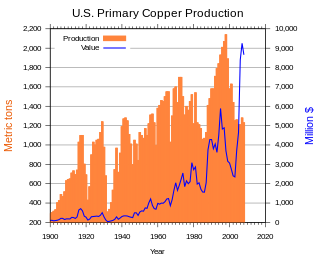
In the United States, copper mining has been a major industry since the rise of the northern Michigan copper district in the 1840s. In 2017, the US produced 1.27 million metric tonnes of copper, worth $8 billion, making it the world's fourth largest copper producer, after Chile, China, and Peru. Copper was produced from 23 mines in the US. Top copper producing states in 2014 were Arizona, Utah, New Mexico, Nevada, and Montana. Minor production also came from Idaho, and Missouri. As of 2014, the US had 45 million tonnes of known remaining reserves of copper, the fifth largest known copper reserves in the world, after Chile, Australia, Peru, and Mexico.
The Admiralty mining district is a mining area in the U.S. state of Alaska which consists of Admiralty Island. Silver and base metals are mined, with gold recovered as a by-product.

The Nonesuch Shale is a Proterozoic geologic formation that outcrops in Michigan and Wisconsin, United States, but has been found by drill holes to extend in the subsurface as far southwest as Iowa.
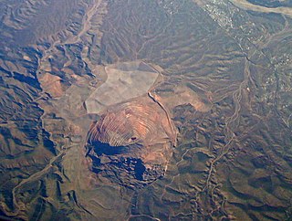
The San Manuel Copper Mine was a surface and underground porphyry copper mine located in San Manuel, Pinal County, Arizona. Frank Schultz was the original discoverer, in 1879, but the main body of the deposits were discovered by Henry W. Nichols in 1942. The exploration drilling went on from 1943 to 1948, with the first mine shaft built 1948. Louis Lesser developed a mining city to service Nichols’ newly discovered deposits, and the development was completed about 1954. The first major production began in 1955. The mine and smelter were permanently closed in 2003.

The Iberian Pyrite Belt is a vast geographical area with particular geological features that stretches along much of the south of the Iberian Peninsula, from Portugal to Spain. It is about 250 km long and 30–50 km wide, running northwest to southeast from Alcácer do Sal (Portugal) to Sevilla (Spain). The mining activity in this region goes back thousands of years.
Carl Michael Lesher is an American geologist. He is an authority on the geology and origin of nickel-copper-platinum group element deposits, especially those associated with komatiites, their physical volcanology and localization, the geochemistry and petrology of associated rocks, and controls on their composition.
The Mineral Exploration Research Centre (MERC) is a semi-autonomous research centre associated with the Harquail School of Earth Sciences at Laurentian University in Sudbury Ontario, Canada, and one of the largest mineral exploration research-teaching clusters in the world. MERC is housed in the Willett Green Miller Mineral and Mining Research Centre on the Laurentian University campus, together with the Ontario Geological Survey, Ontario Geoscience Laboratories, the John B. Gammon Mines Library, and the administrative offices of the Minerals and Mining Division of the Ontario Ministry of Northern Development and Mines.
Rampura Agucha is a zinc and lead mine located on a massive sulfide deposit in the Bhilwara district of Rajasthan, India. Rampura Agucha is located 220 km (140 mi) from Jaipur. It is north of Bhilwara, and northwest of Shahpura. Rampura Agucha is 10 km (6.2 mi) southeast of Gulabpura on NH 79. The mine is owned by Hindustan Zinc Limited (HZL), and has the world's largest deposits of zinc and lead.
Hydrothermal mineral deposits are accumulations of valuable minerals which formed from hot waters circulating in Earth's crust through fractures. They eventually create metallic-rich fluids concentrated in a selected volume of rock, which become supersaturated and then precipitate ore minerals. In some occurrences, minerals can be extracted for a profit by mining. Discovery of mineral deposits consumes considerable time and resources and only about one in every one thousand prospects explored by companies are eventually developed into a mine. A mineral deposit is any geologically significant concentration of an economically useful rock or mineral present in a specified area. The presence of a known but unexploited mineral deposit implies a lack of evidence for profitable extraction.
Michel Jébrak is a Franco-Canadian geologist, academic and a researcher. He is an emeritus professor at University of Quebec’s Department of Earth and Atmospheric Sciences. He is a former Vice-Rector for Research and Creation at UQAM and holder of the UQAT-UQAM Mining Entrepreneurship Chair.
