Orange County, Vermont

Last updated

Orange County
Orange county court house vt.jpg
Orange County Superior Court in Chelsea
Map of Vermont highlighting Orange County.svg
Location within the U.S. state of Vermont
Vermont in United States.svg
Vermont's location within the U.S.
Coordinates: 43°59′45″N72°22′30″W / 43.995815°N 72.374886°W / 43.995815; -72.374886
CountryFlag of the United States.svg United States
StateFlag of Vermont.svg  Vermont
Founded1781
Named for William of Orange (William III of England) [1]
Shire Town Chelsea
Largest town Randolph
Area
  Total692 sq mi (1,790 km2)
  Land687 sq mi (1,780 km2)
  Water5.2 sq mi (13 km2)  0.8%
Population
 (2020)
  Total29,277
  Density42/sq mi (16/km2)
Time zone UTC−5 (Eastern)
  Summer (DST) UTC−4 (EDT)
Congressional district At-large

Orange County is a county located in the U.S. state of Vermont. As of the 2020 census, the population was 29,277. [2] Its shire town (county seat) is the town of Chelsea. [3] Orange County was organized on February 2, 1781, as an original county within the state.[ failed verification ]

Contents

Geography

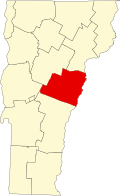
According to the U.S. Census Bureau, the county has an area of 692 square miles (1,790 km2), of which 687 square miles (1,780 km2) is land and 5.2 square miles (13 km2) (0.8%) is water. [4] Orange County is located near the geographic center of the state.

Despite Orange County's hilly terrain, several major routes cross the county. The county is served by both of Vermont's main Interstate highways; with Interstate 89 running north–south through the western side of the county, and Interstate 91 running north–south along the county's eastern edge and the New Hampshire state line. In addition to the Interstates, two U.S. Routes also enter Orange County. U.S. Route 5 parallels I-91 in a north–south route along the county's eastern edge, while U.S. Route 302 runs east–west along the county's northern border with Caledonia County. There are also several Vermont state routes located partially or fully within Orange County. Vermont Route 12, Vermont Route 14, Vermont Route 25, and Vermont Route 110 are all north–south routes, while Vermont Route 66 and Vermont Route 113 are east–west routes.

Adjacent counties

Demographics

Historical population
CensusPop.Note
1790 10,526
1800 18,23873.3%
1810 25,24738.4%
1820 24,681−2.2%
1830 27,28510.6%
1840 27,8732.2%
1850 27,296−2.1%
1860 25,455−6.7%
1870 23,090−9.3%
1880 23,5251.9%
1890 19,575−16.8%
1900 19,313−1.3%
1910 18,703−3.2%
1920 17,279−7.6%
1930 16,694−3.4%
1940 17,0482.1%
1950 17,027−0.1%
1960 16,014−5.9%
1970 17,67610.4%
1980 22,73928.6%
1990 26,14915.0%
2000 28,2267.9%
2010 28,9362.5%
2020 29,2771.2%
U.S. Decennial Census [5]
1790–1960 [6] 1900–1990 [7]
1990–2000 [8] 2010–2018 [2]

2000 census

As of the census [9] of 2000, the county had 28,226 people, 10,936 households, and 7,611 families. The population density was 41 people per square mile (16 people/km2). There were 13,386 housing units at an average density of 19 per square mile (7.3/km2).

The county's racial makeup was 98.02% White, 0.24% Black or African American, 0.27% Native American, 0.35% Asian, 0.04% Pacific Islander, 0.13% from other races, and 0.95% from two or more races. 0.58% of the population were Hispanic or Latino of any race. 24.3% were of English, 12.8% French, 11.5% American, 10.8% Irish, 6.0% German and 5.5% French Canadian ancestry. 97.4% spoke English and 1.5% French as their first language.

There were 10,936 households, of which 33.40% had children under the age of 18 living with them, 56.10% were married couples living together, 8.90% had a female householder with no husband present, and 30.40% were non-families. 23.40% of all households were made up of individuals, and 9.20% had someone living alone who was 65 years of age or older. The average household size was 2.52 and the average family size was 2.97.

25.60% of the county's population was under age 18, 7.80% was from age 18 to 24, 28.20% was from age 25 to 44, 25.60% was from age 45 to 64, and 12.80% was age 65 or older.

The median age was 39 years. For every 100 females, there were 99.20 males. For every 100 females age 18 and over, there were 96.60 males.

The county's median household income was $39,855, and the median family income was $45,771. Males had a median income of $30,679 versus $24,144 for females. The county's per capita income was $18,784. About 6.10% of families and 9.10% of the population were below the poverty line, including 11.40% of those under age 18 and 8.80% of those age 65 or over.

2010 census

As of the 2010 United States Census, the county had 28,936 people, 11,887 households, and 7,865 families. [10] The population density was 42.1 inhabitants per square mile (16.3/km2). There were 14,845 housing units at an average density of 21.6 per square mile (8.3/km2). [11]

The county's racial makeup was 97.0% white, 0.5% Asian, 0.4% black or African American, 0.3% American Indian, 0.3% from other races, and 1.5% from two or more races. Those of Hispanic or Latino origin made up 1.0% of the population. [10] The largest ancestry groups were English (22.4%), Irish (16.5%); French (14.7%), German (10.4%), "American" (7.3%), French Canadian (7.1%), Italian (6.5%); Scottish (6.5%). [12]

Of the 11,887 households, 28.3% had children under age 18 living with them, 51.9% were married couples living together, 9.3% had a female householder with no husband present, 33.8% were non-families, and 25.9% of all households were made up of individuals. The average household size was 2.37 and the average family size was 2.83. The median age was 43.8 years. [10]

The county's median household income was $52,079 and the median family income was $61,221. Males had a median income of $41,281 versus $35,938 for females. The county's per capita income was $25,951. About 6.2% of families and 10.0% of the population were below the poverty line, including 13.2% of those under age 18 and 7.2% of those age 65 or over. [13]

Government

As in all Vermont counties, there is a small executive function that is mostly consolidated at the state level. Remaining county government is judicial. There are no "county taxes."

Legislators

Towns in Orange County are represented in four Vermont Senate Districts. The Orange Senate district includes most of Orange County. It is represented in the Vermont Senate by Mark A. MacDonald (D).

The Washington Senate district includes the Towns of Braintree and Orange, both in Orange County, as well as all of Washington County and the Town of Stowe in Lamoille County. It is represented in the Vermont Senate by Ann Cummings (D), Andrew Perchlik (D), and Anne Watson (D).

The Windsor Senate district includes the Town of Thetford, in Orange County, as well as most of Windsor County. It is represented in the Vermont Senate by Alison Clarkson (D), Dick McCormack (D), and Rebecca White (D).

The Caledonia Senate district includes the Town of Newbury, in Orange County, as well as most of Caledonia County. It is represented in the Vermont Senate by Jane Kitchel (D).

Politics

In 1828, Orange County was won by National Republican Party candidate John Quincy Adams.

In 1832, the county was won by Anti-Masonic Party candidate William Wirt.

From William Henry Harrison in 1836 to Winfield Scott in 1852, the county would vote the Whig Party candidates.

From John C. Frémont in 1856 to Richard Nixon in 1960 (barring 1912, where the county was won by Progressive Party candidate and former president Theodore Roosevelt), the Republican Party would have a 104-year winning streak in the county.

In 1964, the county was won by Democratic Party incumbent President Lyndon B. Johnson, who became not only the first Democratic presidential candidate to win Orange County, but the first to win the state of Vermont entirely.

Following the Democrats victory in 1964, the county went back to voting for Republican candidates for another 20 year winning streak starting with Richard Nixon in 1968 and ending with George H. W. Bush in 1988.

The county would be won by Bill Clinton in both the 1992 and 1996 presidential elections.

George W. Bush would win Orange County in 2000 and would be the last time a Republican presidential candidate would carry the county.

John Kerry won the county in 2004, and Orange County has been won by the Democratic candidates in presidential elections since then.

United States presidential election results for Orange County, Vermont [14]
Year Republican Democratic Third party
No.%No.%No.%
2020 6,18736.13%10,30460.18%6313.69%
2016 5,00734.18%7,54151.48%2,10114.34%
2012 4,58832.65%9,07664.58%3892.77%
2008 5,04733.25%9,79964.56%3332.19%
2004 6,42143.11%8,15954.78%3152.11%
2000 6,85846.67%6,69445.55%1,1437.78%
1996 4,04332.96%6,10749.79%2,11617.25%
1992 4,24931.69%5,77443.06%3,38725.26%
1988 6,15154.35%4,97743.97%1901.68%
1984 6,40760.24%4,08838.44%1401.32%
1980 4,65649.52%3,07932.75%1,66717.73%
1976 4,76858.61%3,17138.98%1962.41%
1972 5,38969.12%2,33229.91%760.97%
1968 4,13566.16%1,87930.06%2363.78%
1964 2,72341.00%3,91858.99%10.02%
1960 5,36377.23%1,58122.77%00.00%
1956 5,61683.95%1,07216.02%20.03%
1952 5,61083.49%1,08216.10%270.40%
1948 4,06176.97%1,13921.59%761.44%
1944 4,11773.77%1,46426.23%00.00%
1940 4,52768.81%2,02930.84%230.35%
1936 4,95673.28%1,79626.56%110.16%
1932 4,30569.30%1,83029.46%771.24%
1928 5,22384.69%91414.82%300.49%
1924 4,65782.85%72412.88%2404.27%
1920 3,71378.93%93819.94%531.13%
1916 2,15159.31%1,37938.02%972.67%
1912 1,28934.19%95625.36%1,52540.45%
1908 2,26274.46%66721.96%1093.59%
1904 2,25977.13%58720.04%832.83%
1900 2,51575.32%74022.16%842.52%
1896 3,06780.20%56714.83%1904.97%
1892 2,39566.18%1,08830.06%1363.76%
1888 2,79262.61%1,27728.64%3908.75%
1884 2,35160.50%1,39235.82%1433.68%
1880 3,10765.14%1,63134.19%320.67%

Education

Vermont State University Randolph, known as Vermont Technical College until July 2023, has its campus in the village of Randolph Center. Vermont technical college 20040926.jpg
Vermont State University Randolph, known as Vermont Technical College until July 2023, has its campus in the village of Randolph Center.

The county is served by four school districts (supervisory unions): [15]

The town of Randolph is also home to the campus of Vermont State University Randolph (which was known as Vermont Technical College, or Vermont Tech, until July 2023). [17]

Orange North Supervisory Union

The union's superintendent is Douglas Shiok, [18] and it includes: [18]

Recreation

Allis State Park [23] is located in the town of Brookfield, and features a hiking trail, picnic pavilion, fire tower, and small campground.

Communities

Towns

Villages

Census-designated places

Unincorporated community

See also

Related Research Articles

<span class="mw-page-title-main">Washington County, Vermont</span> County in Vermont, United States

Washington County is a county located in the U.S. state of Vermont. Named after George Washington, its shire town is the city of Montpelier and the most populous municipality is the city of Barre. As of the 2020 census, the population was 59,807, making it the third-most populous county in Vermont, but the third-least populous capital county in the United States after Hughes County, South Dakota and Franklin County, Kentucky. Washington County comprises the Barre, Vermont micropolitan statistical area. In 2010, the center of population of Vermont was located in Washington County, in the town of Warren.

<span class="mw-page-title-main">Rutland County, Vermont</span> County in Vermont, United States

Rutland County is a county located in the U.S. state of Vermont. As of the 2020 census, the population was 60,572, making it the second-most populous county in Vermont. Its county seat and most populous municipality is the city of Rutland.

<span class="mw-page-title-main">Essex County, Vermont</span> County in Vermont, United States

Essex County is a county located in the northeastern part of the U.S. state of Vermont. As of the 2020 census, the population was 5,920, making it the least-populous county in both Vermont and New England. Its shire town is the municipality of Guildhall. The county was created in 1792 and organized in 1800. Bordered by the Connecticut River next to New Hampshire, Essex County is south of the Canadian province of Quebec. It is the county with the lowest household-income in Vermont.

<span class="mw-page-title-main">Bennington County, Vermont</span> County in Vermont, United States

Bennington County is a county in the U.S. state of Vermont. As of the 2020 census, the population was 37,347. The shire towns are jointly Bennington and Manchester, and the largest municipality is Bennington. The county was created in 1778.

<span class="mw-page-title-main">Addison County, Vermont</span> County in Vermont, United States

Addison County is a county located in the U.S. state of Vermont. As of the 2020 census, the population was 37,363. Its shire town is the town of Middlebury.

<span class="mw-page-title-main">Granville, Vermont</span> Town in Vermont, United States

Granville is a town in Addison County, Vermont, United States. The population was 301 at the 2020 census. The town was originally called Kingston but was renamed in 1833.

<span class="mw-page-title-main">Groton, Vermont</span> Town in Vermont, United States

Groton is a town in Caledonia County, Vermont, United States. The population was 984 at the 2020 census. It contains the places Groton Pond, Rickers Mills, Rickers and West Groton. The unincorporated village of Groton in the southeast corner of town is recorded as the Groton census-designated place (CDP), with a population of 419 at the 2020 census.

<span class="mw-page-title-main">Ryegate, Vermont</span> Town in Vermont, United States

Ryegate is a town in Caledonia County, Vermont, United States. The population was 1,165 at the 2020 census. The town contains the villages of South Ryegate, East Ryegate, and Ryegate Corner.

<span class="mw-page-title-main">Waterford, Vermont</span> Town in Vermont, United States

Waterford is a town in Caledonia County, Vermont, United States. The population was 1,268 at the 2020 census.

<span class="mw-page-title-main">Fairlee, Vermont</span> Town in Vermont, United States

Fairlee is a town in Orange County, Vermont, United States. The population was 988 at the 2020 census. It includes the village of Ely. Fairlee is home to Lake Morey, which claims to have the longest ice skating trail in the United States.

<span class="mw-page-title-main">Randolph, Vermont</span> Town in Vermont, United States

Randolph is a town in Orange County, Vermont, United States. The population was 4,774 at the 2020 census, making Randolph the largest town in Orange County. The town is a commercial center for many of the smaller, rural farming communities that surround it.

<span class="mw-page-title-main">Wells River, Vermont</span> Village in Vermont, United States

Wells River is a village in the town of Newbury in Orange County, Vermont, United States. The population was 431 at the 2020 census. The village center is located at the junction of U.S. Routes 5 and 302.

<span class="mw-page-title-main">West Fairlee, Vermont</span> Town in Vermont, United States

West Fairlee is a town in Orange County, Vermont, United States. The population was 621 at the 2020 census.

<span class="mw-page-title-main">Williamstown, Vermont</span> Town in Vermont, United States

Williamstown is a town in Orange County, Vermont, United States. The population was 3,515 at the 2020 census, making it the second largest municipality in the county.

<span class="mw-page-title-main">Bethel, Vermont</span> Town in Vermont, United States

Bethel is a town in Windsor County, Vermont, United States. The population was 1,942 at the 2020 census. The town includes the locations of Bethel village, Bethel-Gilead, East Bethel, Lilliesville, Lympus, and West Bethel. Bethel is best known for being the source of Bethel White granite which was used to build Union Station and the National Museum of Natural History. Bethel was the first town created by the independent Republic of Vermont in 1779 and was named after the Biblical village of Bethel.

<span class="mw-page-title-main">Newbury (village), Vermont</span> Village in Vermont, United States

Newbury is an incorporated village in the town of Newbury in Orange County, Vermont, United States. The population was 447 at the 2020 census.

<span class="mw-page-title-main">Newbury (town), Vermont</span> Town in Vermont, United States

Newbury is a town in Orange County, Vermont, United States. The population was 2,293 at the 2020 census. Newbury includes the villages of Newbury, Center Newbury, West Newbury, South Newbury, Boltonville, Peach Four Corners, and Wells River.

<span class="mw-page-title-main">Northfield, Vermont</span> Town in Vermont, United States

Northfield is a town in Washington County, Vermont, United States. The town lies in a valley within the Green Mountains and has been home to Norwich University since 1866. It contains the village of Northfield, where over half of the population lives. The town's total population was 5,918 at the 2020 census.

<span class="mw-page-title-main">Bradford, Vermont</span> Town in Vermont, United States

Bradford is a town in Orange County, Vermont, United States. The population was 2,790 at the 2020 census. Bradford is located on the county's eastern border, bordering both the Connecticut River and New Hampshire, and is a commercial center for some of its surrounding towns.

<span class="mw-page-title-main">Addison, Vermont</span> Town in Vermont, United States

Addison is a town in Addison County, Vermont, United States. It was founded October 14, 1761. The population was 1,365 at the 2020 census.

References

  1. "Orange County, Vermont: History and Information".
  2. 1 2 "State & County QuickFacts". United States Census Bureau. Retrieved October 28, 2021.
  3. "Find a County". National Association of Counties. Archived from the original on May 3, 2015. Retrieved June 7, 2011.
  4. "2010 Census Gazetteer Files". United States Census Bureau. August 22, 2012. Retrieved June 29, 2015.
  5. "U.S. Decennial Census". United States Census Bureau. Retrieved June 29, 2015.
  6. "Historical Census Browser". University of Virginia Library. Retrieved June 29, 2015.
  7. Forstall, Richard L., ed. (March 27, 1995). "Population of Counties by Decennial Census: 1900 to 1990". United States Census Bureau. Retrieved June 29, 2015.
  8. "Census 2000 PHC-T-4. Ranking Tables for Counties: 1990 and 2000" (PDF). United States Census Bureau. April 2, 2001. Archived (PDF) from the original on October 9, 2022. Retrieved June 29, 2015.
  9. "U.S. Census website". United States Census Bureau . Retrieved May 14, 2011.
  10. 1 2 3 "DP-1 Profile of General Population and Housing Characteristics: 2010 Demographic Profile Data". United States Census Bureau. Archived from the original on February 13, 2020. Retrieved January 20, 2016.
  11. "Population, Housing Units, Area, and Density: 2010 - County". United States Census Bureau. Archived from the original on February 13, 2020. Retrieved January 20, 2016.
  12. "DP02 SELECTED SOCIAL CHARACTERISTICS IN THE UNITED STATES – 2006-2010 American Community Survey 5-Year Estimates". United States Census Bureau. Archived from the original on February 13, 2020. Retrieved January 20, 2016.
  13. "DP03 SELECTED ECONOMIC CHARACTERISTICS – 2006-2010 American Community Survey 5-Year Estimates". United States Census Bureau. Archived from the original on February 13, 2020. Retrieved January 20, 2016.
  14. Leip, David. "Dave Leip's Atlas of U.S. Presidential Elections". uselectionatlas.org. Retrieved June 8, 2018.
  15. Education, Vermont Department of (April 30, 2009). "Directories : Vermont Supervisory Unions/Districts (O–R)". Archived from the original on June 12, 2009. Retrieved May 30, 2009.
  16. Union, Orange East Supervisory. "Home Page". Archived from the original on May 6, 2013. Retrieved May 30, 2009.
  17. Vermont Technical College
  18. 1 2 Union, Orange North Supervisory. "ONSU Office Staff" . Retrieved May 30, 2009.
  19. School, Orange Center (May 16, 2009). "Message From The Principal". Archived from the original on September 19, 2007. Retrieved May 30, 2009.
  20. School, Washington Village. "Copy: principal's message". Archived from the original on June 8, 2009. Retrieved May 30, 2009.
  21. School, Williamstown Elementary. "homepage". Archived from the original on June 9, 2009. Retrieved May 30, 2009.
  22. School, Williamstown Middle High. "Williamstown Middle High School, Vermont". Archived from the original on February 1, 2009. Retrieved May 30, 2009.
  23. "Vermont State Parks - Allis".

44°01′N72°23′W / 44.01°N 72.38°W / 44.01; -72.38