Northfield, Vermont

Last updated

Northfield
Depot Square, Downtown Northfield.jpg
Depot Square, Downtown Northfield
Motto: 
"Where the Good Life Begins" [1]
Washington County Vermont Incorporated and Unincorporated areas Northfield highlighted.svg
Location in Washington County and the state of Vermont
Usa edcp location map.svg
Red pog.svg
Northfield
Location in the United States
Coordinates: 44°8′28″N72°39′52″W / 44.14111°N 72.66444°W / 44.14111; -72.66444
CountryUnited States
State Vermont
County Washington
Chartered1781 [1]
Incorporated1855 [2]
Area
  Total43.6 sq mi (113.0 km2)
  Land43.5 sq mi (112.7 km2)
  Water0.1 sq mi (0.3 km2)
Elevation
735 ft (441 m)
Population
 (2020)
  Total5,918
  Density140/sq mi (52/km2)
Time zone UTC−5 (EST)
  Summer (DST) UTC−4 (EDT)
ZIP Code
05663
Area code 802
FIPS code 50-50275 [3]
GNIS feature ID1462163 [4]
Website www.northfield-vt.gov

Northfield is a town in Washington County, Vermont, United States. The town lies in a valley within the Green Mountains and has been home to Norwich University since 1866. It contains the village of Northfield, where over half of the population lives. The town's total population was 5,918 at the 2020 census. [5]

Contents

History

Northfield was chartered in 1781. [1] The community was named after Northfield, Massachusetts. [6]

Northfield, was settled between 1785 and the 1820s by Yankees from Connecticut, Massachusetts, and older Vermont towns. The period saw the development of four distinct villages: South Village, Center Village, Factory Village, and Northfield Falls. South Village, with numerous small businesses, became the first to have a distinct identity. Center Village followed, where the first post office, town clerk’s office, and churches were established, coming to serve as Northfield's social and political center. Factory Village (now the village of Northfield), named for the woolen mill, developed next. Lastly, Northfield Falls thrived by the late 1820s. [7]

Initially centered around farming and barter, Northfield's economic activities diversified. Potash production thrived until about 1814, after which Elijah Paine's woolen mill became a major employer. Wool prices declined in the 1840s, but Charles Paine, Elijah Paine's son and president of the Vermont Central Railroad constructed the railroad through town and established its headquarters in Northfield. Hundreds worked for the line. In 1852, the railroad changed ownership and gradually moved to St. Albans, causing the town's population to decline. [7]

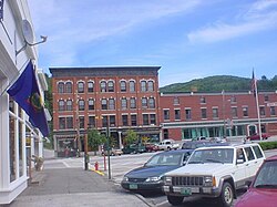
The arrival of the railroad in the 1840s transformed Factory Village into the local hub. Residents began to demand improved infrastructure and services, and petitioned the legislature to establish a separate Village of Northfield. This led to the incorporation of the Village of Northfield on November 14, 1855. [7] [2]

Slate quarrying provided a temporary economic boost in the 1860s and 1870s. [7] Norwich University relocated to Northfield in 1866. [8] In 1889, the first granite shed was built. More were constructed, and by the outbreak of World War I, over 525 people were employed in the granite sheds. Later, the granite industry faced challenges, leading to closures, and by 1954, only the Rock of Ages plant was left. The last plant, Cetrangolo Finishing Works, was closed in 1999. [7]

Geography

According to the United States Census Bureau, the town has a total area of 43.6 square miles (113.0 km2), of which 43.5 square miles (112.7 km2) is land and 0.12 square miles (0.3 km2), or 0.29%, is water. [9]

The geographic center of Vermont is located within the town, with markers on the university campus of the geographical and magnetic centers.

Climate

Northfield has a humid continental climate (Köppen Dfb).

Climate data for Northfield, Vermont (1991–2020 normals, extremes 1887–2018)
MonthJanFebMarAprMayJunJulAugSepOctNovDecYear
Record high °F (°C)68
(20)
71
(22)
82
(28)
90
(32)
93
(34)
96
(36)
98
(37)
97
(36)
95
(35)
85
(29)
76
(24)
68
(20)
98
(37)
Mean daily maximum °F (°C)28.7
(−1.8)
32.4
(0.2)
40.9
(4.9)
53.8
(12.1)
68.0
(20.0)
76.3
(24.6)
80.9
(27.2)
79.2
(26.2)
72.4
(22.4)
58.8
(14.9)
45.6
(7.6)
34.5
(1.4)
56.0
(13.3)
Daily mean °F (°C)17.5
(−8.1)
19.9
(−6.7)
28.8
(−1.8)
41.5
(5.3)
54.3
(12.4)
63.4
(17.4)
68.0
(20.0)
66.1
(18.9)
58.9
(14.9)
46.7
(8.2)
35.8
(2.1)
24.5
(−4.2)
43.8
(6.6)
Mean daily minimum °F (°C)6.3
(−14.3)
7.4
(−13.7)
16.7
(−8.5)
29.1
(−1.6)
40.7
(4.8)
50.6
(10.3)
55.0
(12.8)
53.1
(11.7)
45.5
(7.5)
34.7
(1.5)
25.9
(−3.4)
14.5
(−9.7)
31.6
(−0.2)
Record low °F (°C)−35
(−37)
−39
(−39)
−23
(−31)
−1
(−18)
18
(−8)
27
(−3)
33
(1)
27
(−3)
16
(−9)
8
(−13)
−14
(−26)
−41
(−41)
−41
(−41)
Average precipitation inches (mm)3.21
(82)
2.65
(67)
3.07
(78)
3.66
(93)
3.93
(100)
4.43
(113)
5.04
(128)
3.79
(96)
3.29
(84)
4.62
(117)
3.35
(85)
3.70
(94)
44.74
(1,136)
Average snowfall inches (cm)17.9
(45)
15.0
(38)
13.9
(35)
3.3
(8.4)
0.0
(0.0)
0.0
(0.0)
0.0
(0.0)
0.0
(0.0)
0.0
(0.0)
0.3
(0.76)
4.1
(10)
21.3
(54)
75.8
(193)
Average precipitation days (≥ 0.01 in)10.48.28.310.212.112.911.310.08.711.49.411.4124.3
Average snowy days (≥ 0.1 in)7.35.94.51.20.00.00.00.00.00.32.26.728.1
Source: NOAA [10] [11]

Demographics

Historical population
CensusPop.Note
1800 204
1810 426108.8%
1820 69062.0%
1830 1,412104.6%
1840 2,01342.6%
1850 2,92245.2%
1860 4,32948.2%
1870 3,410−21.2%
1880 2,836−16.8%
1890 2,628−7.3%
1900 2,8558.6%
1910 3,22613.0%
1920 3,096−4.0%
1930 3,43811.0%
1940 3,6014.7%
1950 4,31419.8%
1960 4,5114.6%
1970 4,8708.0%
1980 5,43511.6%
1990 5,6103.2%
2000 5,7913.2%
2010 6,2077.2%
2020 5,918−4.7%
U.S. Decennial Census [12] [13]

As of the census [3] of 2000, there were 5,791 people, 1,819 households, and 1,224 families residing in the town. The population density was 132.5 people per square mile (51.2/km2). There were 1,958 housing units at an average density of 44.8 per square mile (17.3/km2). The racial makeup of the town was 95.41% White, 1.02% Black or African American, 0.36% Native American, 1.33% Asian, 0.43% from other races, and 1.45% from two or more races. Hispanic or Latino of any race were 2.21% of the population.

There were 1,819 households, out of which 32.4% had children under the age of 18 living with them, 53.5% were couples living together and joined in either marriage or civil union, 10.0% had a female householder with no husband present, and 32.7% were non-families. Of all households 24.3% were made up of individuals, and 9.7% had someone living alone who was 65 years of age or older. The average household size was 2.46 and the average family size was 2.95.

In the town, the population was spread out, with 19.4% under the age of 18, 27.2% from 18 to 24, 22.8% from 25 to 44, 18.9% from 45 to 64, and 11.6% who were 65 years of age or older. The median age was 30 years. For every 100 females, there were 122.0 males. For every 100 females age 18 and over, there were 122.5 males.

The median income for a household in the town was $41,523, and the median income for a family was $51,818. Males had a median income of $32,168 versus $24,781 for females. The per capita income for the town was $15,592. About 3.2% of families and 6.7% of the population were below the poverty line, including 6.4% of those under age 18 and 6.2% of those age 65 or over.

Education

Norwich University is a senior military college that enrolls undergraduate students, and has a large online graduate program. [14]

Northfield is part of Paine Mountain Union School District and has two schools: Northfield Elementary School and Northfield Middle/High School. [15]

Winter at Norwich University, the town's main employer, located just south of downtown NorwichUniversityWinter.JPG
Winter at Norwich University, the town's main employer, located just south of downtown

Landmarks

Northfield has five covered bridges. Three covered bridges—Upper Cox, Lower Cox, and Northfield Falls—cross Cox Brook and Dog River within a quarter mile of each other on Cox Brook Road. Just below those bridges, the Slaughterhouse Covered Bridge crosses the Dog River. The Stony Brook Covered Bridge, constructed in 1899, is the last kingpost truss covered bridge built on a Vermont public highway. [16]

Media

Published locally is the Northfield News & Transcript . [17] [18] It is a weekly newspaper and was established in 1878 by George Richmond.

Economy

The town's largest employer is Norwich University, followed by Cabot Hosiery Mills. [19]

Infrastructure

Transportation

Bus

Northfield is served by Green Mountain Transit Agency's commuter route 93 between Montpelier and Northfield.

Roads

Notable people

See also

Related Research Articles

<span class="mw-page-title-main">Norwich, Vermont</span> Town in Vermont, United States

Norwich is a town in Windsor County, Vermont, United States. The population was 3,612 at the 2020 census. Home to some of the state of Vermont's wealthiest residents, the municipality is a commuter town for nearby Hanover, New Hampshire across the Connecticut River. The town is part of the Dresden School District, the first interstate school district in the United States, signed into law by President John F. Kennedy. The town contains the Norwich Mid-Century Modern Historic District.

<span class="mw-page-title-main">Montpelier, Vermont</span> Capital city of Vermont, United States

Montpelier is the capital of the U.S. state of Vermont and the county seat of Washington County. The site of Vermont's state government, it is the least populous state capital in the United States. As of the 2020 census, the population was 8,074. However, the daytime population grows to about 21,000, due to the large number of jobs within city limits. The Vermont College of Fine Arts is located in the municipality. It was named after Montpellier, a city in the south of France.

<span class="mw-page-title-main">Windsor County, Vermont</span> County in Vermont, United States

Windsor County is a county located in the U.S. state of Vermont. As of the 2020 census, the population was 57,753. The shire town is the town of Woodstock. The county's largest municipality is the town of Hartford.

<span class="mw-page-title-main">Washington County, Vermont</span> County in Vermont, United States

Washington County is a county located in the U.S. state of Vermont. Named after George Washington, its shire town is the city of Montpelier and the most populous municipality is the city of Barre. As of the 2020 census, the population was 59,807, making it the third-most populous county in Vermont, but the third-least populous capital county in the United States after Hughes County, South Dakota and Franklin County, Kentucky. Washington County comprises the Barre, Vermont micropolitan statistical area. In 2010, the center of population of Vermont was located in Washington County, in the town of Warren.

<span class="mw-page-title-main">Danville, Vermont</span> Town in Vermont, United States

Danville is a town in Caledonia County, Vermont, United States. The population was 2,335 at the 2020 census. The primary settlement in town is recorded as the Danville census-designated place (CDP) and had a population of 385 at the 2020 census.

<span class="mw-page-title-main">Eden, Vermont</span> Town in Vermont, United States

Eden is a town in Lamoille County, Vermont, United States. The population was 1,338 at the 2020 census.

<span class="mw-page-title-main">Braintree, Vermont</span> Town in Vermont, United States

Braintree is a town in Orange County, Vermont, United States created by Vermont charter on August 1, 1781. The population was 1,207 at the 2020 census. Braintree includes the places Braintree Center, Braintree Hill, East Braintree, West Braintree, Peth and Snowsville.

<span class="mw-page-title-main">Brookfield, Vermont</span> Town in Vermont, United States

Brookfield is a town in Orange County, Vermont, United States. It was created by Vermont charter on August 5, 1781. The population was 1,244 at the 2020 census. Brookfield is best known for its floating bridge which spans Sunset Lake buoyed by pontoons. The bridge, which is the only floating bridge east of the Mississippi River, was originally built in 1820 by Luther Adams and his neighbors. Sunset Lake is also the site of an annual ice harvesting festival. Brookfield boasts that it has Vermont's oldest continually operating library dating back to 1791. In 2006, Brookfield was one of the first American towns to have its citizens pass a resolution endorsing the impeachment of President George W. Bush. As of September 2010, the floating bridge was closed for repairs. Work began in 2014, and was completed May 2015. There was a celebration from May 23–24, 2015, to memorialize the event. Governor Peter Shumlin attended, and cadets from Norwich University provided traffic control.

<span class="mw-page-title-main">Orange, Vermont</span> Town in Vermont, United States

Orange is a town in Orange County, Vermont, United States. The population was 1,048 at the 2020 census.

<span class="mw-page-title-main">Wells River, Vermont</span> Village in Vermont, United States

Wells River is a village in the town of Newbury in Orange County, Vermont, United States. The population was 431 at the 2020 census. The village center is located at the junction of U.S. Routes 5 and 302.

<span class="mw-page-title-main">Proctor, Vermont</span> Town in Vermont, United States

Proctor is a town in Rutland County, Vermont, United States. The population was 1,763 at the 2020 census. Proctor is home to the Vermont Marble Museum and Wilson Castle.

<span class="mw-page-title-main">Berlin, Vermont</span> Town in Vermont, United States

Berlin is a town in Washington County, Vermont, United States, founded in 1763.

<span class="mw-page-title-main">Roxbury, Vermont</span> Town in Vermont, United States

Roxbury is a town in Washington County, Vermont, United States, created by Vermont charter on August 6, 1781. The population was 678 at the 2020 census.

<span class="mw-page-title-main">White River Junction, Vermont</span> Census-designated place in Vermont, United States

White River Junction is an unincorporated village and census-designated place (CDP) in the town of Hartford in Windsor County, Vermont, United States. The population was 2,528 at the 2020 census, up from 2,286 in 2010, making it the largest community within the town of Hartford.

<span class="mw-page-title-main">Windsor, Vermont</span> Town in Vermont, United States

Windsor is a town in Windsor County, Vermont, United States. As the "Birthplace of Vermont", the town is where the Constitution of Vermont was adopted in 1777, thus marking the founding of the Vermont Republic, a sovereign state until 1791, when Vermont joined the United States. Over much of its history, Windsor was home to a variety of manufacturing enterprises. Its population was 3,559 at the 2020 census.

<span class="mw-page-title-main">Northfield, Massachusetts</span> Town in Massachusetts, United States

Northfield is a town in Franklin County, Massachusetts, United States. Northfield was first settled in 1673. The population was 2,866 at the 2020 census. It is part of the Springfield, Massachusetts Metropolitan Statistical Area. The Connecticut River runs through the town, dividing West Northfield from East Northfield and the village of Northfield, where the town hall is located.

<span class="mw-page-title-main">Middlebury, Vermont</span> Town in Vermont, United States

Middlebury is the shire town of Addison County, Vermont, United States. As of the 2020 census, the population was 9,152. Middlebury is home to Middlebury College and the Henry Sheldon Museum of Vermont History.

<span class="mw-page-title-main">Albany, Vermont</span> Town in Vermont, United States

Albany is a town in Orleans County, Vermont, United States. The population was 976 at the 2020 census. Albany contains four villages: the incorporated village of Albany, and the unincorporated villages of Albany Center, East Albany and South Albany.

<span class="mw-page-title-main">Ludlow (village), Vermont</span> Village in Vermont, United States

Ludlow is an incorporated village within the town of Ludlow, Windsor County, Vermont, United States. It is sometimes called Ludlow Village, to distinguish it from the surrounding town of the same name. The population was 773 at the 2020 census.

<span class="mw-page-title-main">Rutland (town), Vermont</span> Town in Vermont, United States

Rutland is a town in Rutland County, Vermont, United States. As of the 2020 census, the population was 3,924. Rutland Town completely surrounds Rutland City, which is a separate municipality. The villages of the town effectively comprise the inner suburbs of Rutland City.

References

  1. 1 2 3 "Town of Northfield official website". Town of Northfield official website. Retrieved November 6, 2012.
  2. 1 2 "Northfield Vermont". City-Data.com. Retrieved November 6, 2012.
  3. 1 2 "U.S. Census website". United States Census Bureau . Retrieved January 31, 2008.
  4. "US Board on Geographic Names". United States Geological Survey. October 25, 2007. Retrieved January 31, 2008.
  5. "Census - Geography Profile:Northfield town, Washington County, Vermont". United States Census Bureau . Retrieved January 3, 2022.
  6. "Profile for Northfield, Vermont, VT". ePodunk. Retrieved November 6, 2012.
  7. 1 2 3 4 5 "Northfield Town History". Northfield Historical Society. Archived from the original on June 5, 2023. Retrieved December 16, 2023.
  8. "This Place in History: Norwich University". Vermont Historical Society. Retrieved December 16, 2023.
  9. "Geographic Identifiers: 2010 Demographic Profile Data (G001): Northfield town, Washington County, Vermont". United States Census Bureau . Retrieved September 18, 2012.
  10. "NOWData - NOAA Online Weather Data". National Oceanic and Atmospheric Administration. Retrieved December 16, 2023.
  11. "Summary of Monthly Normals 1991-2020". National Oceanic and Atmospheric Administration. Retrieved December 16, 2023.
  12. "Census of Population and Housing". Census.gov. Retrieved June 4, 2015.
  13. "Vermont History Explorer" . Retrieved August 7, 2015.
  14. Norwich University
  15. "Paine Mountain School District Board / About PMSD". Central Vermont Supervisory Union. Retrieved December 16, 2023.
  16. Bell, Shannon. "Covered Bridges of Northfield". National Park Service. Retrieved December 16, 2023.
  17. "The Northfield News". The Northfield News. Retrieved November 6, 2012.
  18. "Times Argus". Times Argus. Retrieved November 6, 2012.
  19. "Darn Tough sock factory expansion will add 250 to 300 jobs in Northfield". VTDigger. February 8, 2015. Retrieved February 4, 2017.
  20. Cherrington, Ernest Hurst (1925). Standard Encyclopedia of the Alcohol Problem. Vol. 1. American Issue Publishing Company. p. 203. Retrieved July 27, 2022 via Internet Archive.PD-icon.svg This article incorporates text from this source, which is in the public domain .
  21. Baldwin, Frederick W. (1916). History of Bank of Orleans, Irasburgh National Bank of Orleans, Barton National Bank, Barton Savings Bank and Trust Company. Burlington, VT: Free Press Printing Company. pp. 109–110.
  22. Lasher, George Starr (November 1, 1946). "Makes Adjutant General a Member". The Rattle of Theta Chi. Trenton, NJ: Theta Chi Fraternity: 19.
  23. Doyle, William (2003). "Joint Senate Resolution 130". leg.state.vt.us. Vermont State Senate.
  24. "Obituary, Beatrice Corliss". The Boston Globe . Boston, MA. January 17, 1995. p. 17 via Newspapers.com.
  25. Vermont Birth Records, 1909–2008, entry for Reginald Maurice Cram, retrieved December 12, 2013
  26. Ellis, William Arba (1911). Norwich University, 1819–1911; Her History, Her Graduates, Her Roll of Honor. The Capital City Press. pp.  391. joseph h. denny vermont.
  27. Duffy, John J. (2003). The Vermont Encyclopedia. UPNE. p. 169. ISBN   9781584650867.
  28. Beckwith, Albert Clayton (1912). History of Walworth County, Wisconsin. Vol. I. Indianapolis, IN: B. F. Bowen & Company. pp. 534–535 via Google Books.
  29. White, James T. (1922). The National Cyclopaedia of American Biography. Vol. 18. New York, NY: James T. White & Company. p. 327.
  30. Spofford, Ainsworth R. (1898). The National Cyclopaedia of American Biography. Vol. VIII. New York, NY: James T. White & Company. p. 318 via Google Books.
  31. "PLUMLEY, Charles Albert, (1875 – 1964)". Biographical Directory of the United States Congress. Retrieved November 6, 2012.
  32. "PLUMLEY, Frank, (1844 – 1924)". Biographical Directory of the United States Congress. Retrieved November 6, 2012.
  33. Ellis, William Arba (1898). Norwich University: Her History, Her Graduates, Her Roll of Honor. Concord, NH: Rumford Press. p. 115 via Google Books.
  34. Civil Government, State of Vermont. Montpelier, VT: Vermont Secretary of State. 2005. p. 355 via Google Books.
  35. Mearhoff, Sarah; Keays, Alan J.; Weinstein, Ethan (June 22, 2022). "Phil Scott appoints former Administration Secretary Susanne Young to complete attorney general's term". VT Digger. Montpelier, VT.