Elkton, Minnesota

Last updated

Elkton, Minnesota
Mower County Minnesota Incorporated and Unincorporated areas Elkton Highlighted.svg
Location in Mower County and the state of Minnesota
Coordinates: 43°39′37″N92°42′23″W / 43.66028°N 92.70639°W / 43.66028; -92.70639
CountryUnited States
State Minnesota
County Mower
PlattedJanuary 25, 1887
Incorporated February 6, 1906
Government
   Mayor Sally Vietor
Area
[1]
  Total1.281 sq mi (3.318 km2)
  Land1.281 sq mi (3.318 km2)
  Water0.000 sq mi (0.000 km2)
Elevation
[2]
1,381 ft (421 m)
Population
 (2020) [3]
  Total130
  Estimate 
(2022) [4]
133
  Density103.8/sq mi (40.1/km2)
Time zone UTC–6 (Central (CST))
  Summer (DST) UTC–5 (CDT)
ZIP Code
55933
Area code 507
FIPS code 27-18728
GNIS feature ID2394660 [2]
Sales tax 7.375% [5]

Elkton is a city in Marshall Township, Mower County, Minnesota, United States. The population was 130 at the 2020 census. [3]

Contents

History

Elkton was platted on January 25, 1887, by W.E. Richardson and Frank A. Day. It was incorporated on January 2, 1906. On January 30, 1906, the people of the township elected a president of the city council, three councilmen, a recorder, a treasurer, two justices of the peace, two constables and an assessor. A sidewalk was constructed on Main Street in 1908, electricity was brought in the late 1920s, and the water system was built in 1946. Curbs, gutters and new streets were added in 1965.

Geography

Elkton is in central Mower County, 15 miles (24 km) east of Austin, the county seat. It is bordered to the south, east, and west by Marshall Township and to the north by Dexter Township.

According to the U.S. Census Bureau, Elkton has a total area of 1.281 square miles (3.32 km2), all land. [1] The city is drained by Schwerin Creek, which flows northwest to Rose Creek, a tributary of the Cedar River.

Demographics

Historical population
CensusPop.Note
1910 86
1920 10218.6%
1930 91−10.8%
1940 11728.6%
1950 14120.5%
1960 1474.3%
1970 134−8.8%
1980 1393.7%
1990 1422.2%
2000 1494.9%
2010 141−5.4%
2020 130−7.8%
2022 (est.)133 [4] 2.3%
U.S. Decennial Census [6]
2020 Census [3]

2010 census

As of the 2010 census, there were 141 people, 58 households, and 40 families living in the city. The population density was 108.5 inhabitants per square mile (41.9/km2). There were 59 housing units at an average density of 45.4 per square mile (17.5/km2). The racial makeup of the city was 93.6% White, 0.7% Pacific Islander, 1.4% from other races, and 4.3% from two or more races. Hispanic or Latino of any race were 1.4% of the population.

There were 58 households, of which 32.8% had children under the age of 18 living with them, 51.7% were married couples living together, 15.5% had a female householder with no husband present, 1.7% had a male householder with no wife present, and 31.0% were non-families. 27.6% of all households were made up of individuals, and 12% had someone living alone who was 65 years of age or older. The average household size was 2.43 and the average family size was 3.00.

The median age in the city was 40.8 years. 29.8% of residents were under the age of 18; 5.6% were between the ages of 18 and 24; 22% were from 25 to 44; 28.4% were from 45 to 64; and 14.2% were 65 years of age or older. The gender makeup of the city was 47.5% male and 52.5% female.

2000 census

As of the 2000 census, there were 149 people, 52 households, and 37 families living in the city. The population density was 113.7 inhabitants per square mile (43.9/km2). There were 59 housing units at an average density of 45.0 per square mile (17.4/km2). The racial makeup of the city was 99.33% White, and 0.67% from two or more races. Hispanic or Latino of any race were 4.03% of the population.

There were 52 households, out of which 40.4% had children under the age of 18 living with them, 63.5% were married couples living together, 1.9% had a female householder with no husband present, and 28.8% were non-families. 26.9% of all households were made up of individuals, and 15.4% had someone living alone who was 65 years of age or older. The average household size was 2.87 and the average family size was 3.54.

In the city, the population was spread out, with 35.6% under the age of 18, 6.0% from 18 to 24, 24.8% from 25 to 44, 22.1% from 45 to 64, and 11.4% who were 65 years of age or older. The median age was 30 years. For every 100 females, there were 112.9 males. For every 100 females age 18 and over, there were 104.3 males.

The median income for a household in the city was $32,813, and the median income for a family was $43,125. Males had a median income of $26,875 versus $29,688 for females. The per capita income for the city was $14,950. There were 2.9% of families and 5.8% of the population living below the poverty line, including 10.4% of under eighteens and none of those over 64.

Notable people

Related Research Articles

<span class="mw-page-title-main">Mower County, Minnesota</span> County in Minnesota, United States

Mower County is a county in the U.S. state of Minnesota. As of the 2020 census, the population was 40,029. The county seat is Austin. Mower County comprises the Austin Micropolitan Statistical Area and is included in the Rochester-Austin Combined Statistical Area. Lake Louise State Park is in southeastern Mower County, near Le Roy.

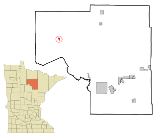
Elkton Township is a township in Clay County, Minnesota, United States. The population was 283 at the 2000 census.

<span class="mw-page-title-main">Squaw Lake, Minnesota</span> City in Minnesota, United States

Squaw Lake is a city in Itasca County, Minnesota, United States. The population was 98 at the 2020 census.

<span class="mw-page-title-main">Lake Bronson, Minnesota</span> City in Minnesota, United States

Lake Bronson is a city in Kittson County, Minnesota, United States. The population was 178 at the 2020 census. Lake Bronson State Park is nearby.

<span class="mw-page-title-main">Elmdale, Minnesota</span> City in Minnesota, United States

Elmdale is a city in Morrison County, Minnesota, United States. The population was 114 at the 2020 census.

<span class="mw-page-title-main">Adams, Minnesota</span> City in Minnesota, United States

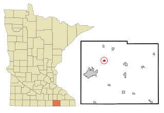
Adams is a city in Adams Township, Mower County, Minnesota, United States. The population was 683 at the 2020 census, down from 787 in 2010.

<span class="mw-page-title-main">Brownsdale, Minnesota</span> City in Minnesota, United States

Brownsdale is a city in Mower County, Minnesota, United States. The population was 633 at the 2020 census.

<span class="mw-page-title-main">Dexter, Minnesota</span> City in Minnesota, United States

Dexter is a city Mower County, Minnesota, United States. The population was 324 at the 2020 census.

Dexter Township is a township in Mower County, Minnesota, United States. The population was 289 at the 2000 census. The largest town in the township is Dexter with a population of 333 people. All other areas of the township are unincorporated areas. It is named for Dexter Parritt, an early settler.

<span class="mw-page-title-main">Grand Meadow, Minnesota</span> City in Minnesota, United States

Grand Meadow is a city in Mower County, Minnesota, United States. The city is on the boundary between Grand Meadow Township and Frankford Township, and it is politically independent of both townships. The population was 1,127 at the 2020 census.

<span class="mw-page-title-main">Le Roy, Minnesota</span> City in Minnesota, United States

Le Roy is a city in Mower County, Minnesota, United States, surrounded by Le Roy Township. The population was 957 at the 2020 census. Lake Louise State Park is just outside the town.

<span class="mw-page-title-main">Mapleview, Minnesota</span> City in Minnesota, United States

Mapleview is a city in Lansing Township, Mower County, Minnesota, United States. It is situated directly to the north of Austin's Oakwood Cemetery and can more or less be considered a suburb of Austin, although it is politically independent of it. The population was 176 at the 2010 census. It was named for a row of maple trees that once stood on the west side of town.

Marshall Township is a township in Mower County, Minnesota, United States. The population was 382 at the 2000 census. The largest town in the township is Elkton with a population of 149 people. All other area in the township is unincorporated.

Pleasant Valley Township is a township in Mower County, Minnesota, United States. The population was 308 at the 2000 census. There are no recognized cities or towns and the township is entirely an unincorporated area.

<span class="mw-page-title-main">Racine, Minnesota</span> City in Minnesota, United States

Racine is a city in Racine Township, Mower County, Minnesota, United States. The population was 442 at the 2010 census.

<span class="mw-page-title-main">Rose Creek, Minnesota</span> City in Minnesota, United States

Rose Creek is a city in Windom Township, Mower County, Minnesota, United States. The population was 394 at the 2010 census.

<span class="mw-page-title-main">Sargeant, Minnesota</span> City in Minnesota, United States

Sargeant is a city in Sargeant Township, Mower County, Minnesota, United States. The population was 61 at the 2010 census.

<span class="mw-page-title-main">Taopi, Minnesota</span> City in Minnesota, United States

Taopi is a city in Lodi Township, Mower County, Minnesota, United States. The population was 58 at the 2010 census. It is located near the source of the Wapsipinicon River.

Udolpho Township is a township in Mower County, Minnesota, United States. The population was 458 at the 2000 census. There are no recognized cities or towns and the whole township is an unincorporated area. Blooming Prairie is only about a quarter of a mile away in Steele County to the north. The township's name is taken from a gothic novel titled The Mysteries of Udolpho by the English author Ann Radcliffe.

<span class="mw-page-title-main">Waltham, Minnesota</span> City in Minnesota, United States

Waltham is a city in Waltham Township, Mower County, Minnesota, United States. The population was 151 at the 2010 census.

References

  1. 1 2 "2023 U.S. Gazetteer Files: Minnesota". United States Census Bureau. Retrieved February 9, 2024.
  2. 1 2 U.S. Geological Survey Geographic Names Information System: Elkton, Minnesota
  3. 1 2 3 "Explore Census Data". United States Census Bureau . Retrieved February 2, 2024.
  4. 1 2 "City and Town Population Totals: 2020-2022". United States Census Bureau. February 2, 2024. Retrieved February 2, 2024.
  5. "Elkton (MN) sales tax rate" . Retrieved February 2, 2024.
  6. "Census of Population and Housing". census.gov. Retrieved June 4, 2015.
  7. Wisconsin Blue Book 1995-1996, "Biographical Sketch of Alvin Baldus", pg. 41

Further reading

43°39′46″N92°42′31″W / 43.66278°N 92.70861°W / 43.66278; -92.70861