Coppull is a village and civil parish in Lancashire, England. It is part of the Borough of Chorley, lies around 300 feet (91 m) above sea level. Its population is around 8,000, having been counted at 8,300 in the 2021Census. It is bounded by Whittle Brook, Clancutt Brook, the River Yarrow, Eller Brook, Hic-Bibi Brook and Stars Brook. Coppull is located between Chorley and Standish, Greater Manchester, to the east of the A49 road near Charnock Richard.
Agecroft Colliery was a coal mine on the Manchester Coalfield that opened in 1844 in the Agecroft district of Pendlebury, Lancashire, England. It exploited the coal seams of the Middle Coal Measures of the Lancashire Coalfield. The colliery had two spells of use; the first between 1844 and 1932, when the most accessible coal seams were exploited, and a second lease of life after extensive development in the late 1950s to access the deepest seams.

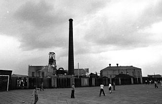
Chisnall Hall Colliery was a coal mine in Coppull in Lancashire, England. It was the largest coal mine on the Lancashire Coalfield north of Wigan. The colliery on Coppull Moor was owned by Pearson and Knowles Coal and Iron Company in 1896 when it employed 135 underground and 48 surface workers. The colliery appeared on maps in 1908 as a coal mine with two shafts and railway sidings connecting its 1.5-mile mineral railway to the London and North Western Railway's West Coast Main Line. In 1930, Pearson & Knowles merged with the Wigan Coal and Iron Company and others and their collieries became the property of the Wigan Coal Corporation. More than 1,000 people were employed there in 1933 and more than 300,000 tonnes of coal were produced annually.

The Lancashire Coalfield in North West England was an important British coalfield. Its coal seams were formed from the vegetation of tropical swampy forests in the Carboniferous period over 300 million years ago.
The Astley and Tyldesley Collieries Company formed in 1900 owned coal mines on the Lancashire Coalfield south of the railway in Astley and Tyldesley, then in the historic county of Lancashire, England. The company became part of Manchester Collieries in 1929 and some of its collieries were nationalised in 1947.
Tyldesley Coal Company was a coal mining company formed in 1870 in Tyldesley, on the Manchester Coalfield in the historic county of Lancashire, England that had its origins in Yew Tree Colliery, the location for a mining disaster that killed 25 men and boys in 1858.
Bedford Colliery, also known as Wood End Pit, was a coal mine on the Manchester Coalfield in Bedford, Leigh, Lancashire, England. The colliery was owned by John Speakman, who started sinking two shafts on land at Wood End Farm in the northeast part of Bedford, south of the London and North Western Railway's Tyldesley Loopline in about 1874. Speakman's father owned Priestners, Bankfield, and Broadoak collieries in Westleigh. Bedford Colliery remained in the possession of the Speakman family until it was amalgamated with Manchester Collieries in 1929.
Manchester Collieries was a coal mining company with headquarters in Walkden formed from a group of independent companies operating on the Manchester Coalfield in 1929. The Mining Industry Act of 1926 attempted to stem the post-war decline in coal mining and encourage independent companies to merge in order to modernise and better survive the economic conditions of the day. Robert Burrows of the Atherton company Fletcher Burrows proposed a merger of several independent companies operating to the west of Manchester. The merger was agreed and took place in March 1929.
The Clifton and Kersley Coal Company or Clifton and Kearsley Coal Company was a coal mining company that operated in Clifton and Kearsley on the south side of the Irwell Valley, then in the historic county of Lancashire, England. Its collieries exploited the coal mines (seams) of the middle coal measures in the Manchester Coalfield. Pits had been sunk in the 1730s and in the 1740s John Heathcote who owned the pits employed Matthew Fletcher. The Fletchers had extensive interests in coal mining in the area and, by the 1750s, Fletcher owned the collieries.

Astley Green Colliery was a coal mine in Astley, Greater Manchester, then in the historic county of Lancashire, England. It was the last colliery to be sunk in Astley. Sinking commenced in 1908 by the Pilkington Colliery Company, a subsidiary of the Clifton and Kersley Coal Company, at the southern edge of the Manchester Coalfield, working the Middle Coal Measures where they dipped under the Permian age rocks under Chat Moss. The colliery was north of the Bridgewater Canal. In 1929 it became part of Manchester Collieries, and in 1947 was nationalised and integrated into the National Coal Board. It closed in 1970, and is now Astley Green Colliery Museum.
The Wigan Coal and Iron Company was formed when collieries on the Lancashire Coalfield owned by John Lancaster were acquired by Lord Lindsay, the Earl of Crawford and Balcarres, owner of the Haigh Colliery in 1865. The company owned collieries in Haigh, Aspull, Standish, Westhoughton, Blackrod, Westleigh and St Helens and large furnaces and iron-works near Wigan and the Manton Colliery in Nottinghamshire.
Parsonage Colliery was a coal mine operating on the Lancashire Coalfield in Leigh, then in the historic county of Lancashire, England. The colliery, close to the centre of Leigh and the Bolton and Leigh Railway was sunk between 1913 and 1920 by the Wigan Coal and Iron Company and the first coal was wound to the surface in 1921. For many years its shafts to the Arley mine were the deepest in the country. The pit was close to the town centre and large pillars of coal were left under the parish church and the town's large cotton mills.

Gibfield Colliery was a coal mine owned by Fletcher, Burrows and Company in Atherton, then in the historic county of Lancashire, England.
Gin Pit was a coal mine operating on the Lancashire Coalfield from the 1840s in Tyldesley, Greater Manchester then in the historic county of Lancashire, England. It exploited the Middle Coal Measures of the Manchester Coalfield and was situated to the south of the Tyldesley Loopline.
Peelwood Colliery was a coal mine operating on the Manchester Coalfield after 1883 in Shakerley, Tyldesley, Greater Manchester, then in the historic county of Lancashire, England.
Mosley Common Colliery was a coal mine originally owned by the Bridgewater Trustees operating on the Manchester Coalfield after 1866 in Mosley Common, Greater Manchester, then in the historic county of Lancashire, England. The colliery eventually had five shafts and became the largest colliery on the Lancashire Coalfield with access to around 270 million tons of coal under the Permian rocks to the south.

Bradford Colliery was a coal mine in Bradford, Manchester, England. Although part of the Manchester Coalfield, the seams of the Bradford Coalfield correspond more closely to those of the Oldham Coalfield. The Bradford Coalfield is crossed by a number of fault lines, principally the Bradford Fault, which was reactivated by mining activity in the mid-1960s.

Haydock Collieries were collieries situated in and around Haydock on the Lancashire Coalfield, England. The company which operated the collieries was Richard Evans & Co Ltd.

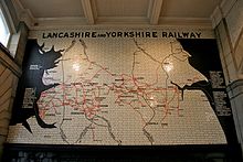
The Burnley Coalfield is the most northerly portion of the Lancashire Coalfield. Surrounding Burnley, Nelson, Blackburn and Accrington, it is separated from the larger southern part by an area of Millstone Grit that forms the Rossendale anticline. Occupying a syncline, it stretches from Blackburn past Colne to the Yorkshire border where its eastern flank is the Pennine anticline.
Towneley Colliery or Towneley Desmesne was a coal mine on the Burnley Coalfield in Burnley, Lancashire, England. Sunk in the late 1860s, it was linked to the Lancashire and Yorkshire Railway's Burnley to Todmorden line which became known as the Copy Pit route and, by tramway, to the Leeds and Liverpool Canal.