
The city of Davenport, Iowa, United States has neighborhoods dating back to the 1840s. The Davenport Plan and Zoning Commission divided the city into five areas: downtown, central, east end, near north, and northwest and west end. The neighborhoods contain many architectural designs, including Victorian, Queen Anne, and Tudor Revival. Many of the original neighborhoods were first inhabited by German settlers.

Mount Pleasant Historic District is a historic district encompassing a cluster of well-preserved 19th-century residential buildings on Forest Street and Mount Pleasant Avenue in the Roxbury neighborhood of Boston, Massachusetts. First developed in 1833, it was one Roxbury's first speculative residential subdivision developments. The district features Greek Revival, Italianate, and Romanesque architecture, and was added to the National Register of Historic Places in 1989.

The Sumner Hill Historic District encompasses a predominantly residential area of high-quality late 19th-century residences in the Jamaica Plain neighborhood of Boston, Massachusetts. It is roughly bounded by Seaverns Avenue, Everett Street, Carolina Avenue, and Newbern Street just east of the neighborhoods commercial Centre Street area. The district features Second Empire, Italianate, and Queen Anne style architecture, and was listed on the National Register of Historic Places in 1987.

The Central Street District is a historic district encompassing the traditional heart of Andover, Massachusetts prior to the development in the later 19th century of the current town center. It consists mainly of residential and religious properties along Central Street, from Phillips Street in the south to Essex Street in the north. All of the listed properties have frontage on Central Street, even if their addresses are on one of the adjacent streets.

Fort Hill is a 0.4 square mile neighborhood and historic district of Roxbury, in Boston, Massachusetts. The approximate boundaries of Fort Hill are Malcolm X Boulevard on the north, Washington Street on the southeast, and Columbus Avenue on the southwest.

The Francis Street–Fenwood Road Historic District encompasses a small but cohesive early 20th-century residential area and streetcar suburb in the Longwood area of Boston, Massachusetts. Bounded by Huntington Avenue, Francis Street, Vining Avenue, Fenwood Road, and St. Albans Road, it includes a collection of two and three-family houses, as well as two apartment houses, a school, and one commercial building, all of which predate the large medical complexes that dominate the Longwood area. The district was listed on the National Register of Historic Places in 2016.

The Governor Shirley Square Historic District encompasses a cluster of civic, residential, and religious buildings at the junction of Dudley, Hampden, and Dunmore Streets in the Roxbury neighborhood of Boston, Massachusetts. Named for colonial governor William Shirley in 1913, the square was developed in the 1870s and 1880s as a major locus of civic development after the city of Roxbury was annexed to Boston in 1868. The district was listed on the National Register of Historic Places in 2016.

The Watertown Center Historic District encompasses the historic village center of Watertown, Connecticut. It exhibits architectural and historic changes from the early 1700s into the 20th century. It is roughly bounded by Main, Warren, North, Woodbury, Woodruff, and Academy Hill Roads, and was listed on the National Register of Historic Places in 2001.

The Elm Street Historic District encompasses a colonial-era roadway layout and a cross-section of historical residential architecture styles in Rocky Hill, Connecticut. Elm Street between Silas Deane Highway and Grimes Road is an old colonial road, laid out in the late 17th century, and has retained an unusually wide right-of-way, typical for the period but rarely preserved. The houses lining it date from 1769 to the 1930s. The district was listed on the National Register of Historic Places in 1998.

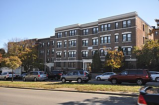
The Columbia Road–Bellevue Street Historic District encompasses a collection of brick residential apartment houses on Columbia Road and Bellevue Street in the Dorchester neighborhood of Boston, Massachusetts. Arrayed mainly on Columbia Road between Wheelock Avenue and Bodwell Street, south of the Uphams Corner commercial area, area collection of primarily late 19th and early 20th-century multiunit residential buildings, built when the area was developed as a streetcar suburb. Most of these are Colonial Revival masonry or frame buildings three and four stories in height, although some exhibit Queen Anne features. There are a few older Greek Revival buildings in the district, and a number of apartment blocks built in the 1920s during a second phase of development.
The Columbia Road–Strathcona Road Historic District encompasses a collection of brick residential apartment houses on Columbia and Strathcona Roads in the Roxbury neighborhood of Boston, Massachusetts. Arrayed on the southeast side of Columbia Road between Washington and Brinsley Streets are several multistory buildings with well-preserved Colonial Revival features. They were constructed in the first two decades of the 20th century, when the area was developed as a streetcar suburb. These were built mainly by Jewish developers Saul E. Moffie and Samuel Levy to serve a growing Jewish population in the area.
The Esmond Street Historic District is a historic district encompassing a small residential area in the Dorchester neighborhood of Boston, Massachusetts. Centered on a stretch of Esmond Street, the area was developed between 1884 and 1928, and includes a fine sample of Colonial Revival and Queen Anne architecture. The district was listed on the National Register of Historic Places in 2018.

The Intervale Street-Columbia Road Historic District is a historic district encompassing a small residential area in the Dorchester neighborhood of Boston, Massachusetts. Centered on a stretch of Intervale Street, the area was developed in the early 20th century during a major Jewish migration, and includes a fine sample of Colonial Revival architecture. The district was listed on the National Register of Historic Places in 2019.

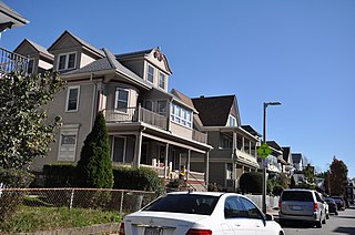
Newport Village Historic District is a neighborhood in Boardman, Ohio. The neighborhood is bordered by the City of Youngstown, Ohio to the north and east, Glenwood Avenue to the west, and Forest Glen Estates Historic District to the south. Newport Village is known for its quaint tree-lined residential streets and early twentieth century Tudor revival and colonial revival architecture.

The Ascension-Caproni Historic District encompasses a mixed collection of late 19th and early 20th century architecture along Washington, Newcomb, and Thorndike Streets in the Roxbury neighborhood of Boston, Massachusetts. Including religious, residential, commercial, and industrial buildings, it encapsulates the area's transition from industrial to residential uses between about 1850 and 1930. The district was listed on the National Register of Historic Places in 2019.

The Intervale Street-Blue Hill Avenue Historic District is a historic district encompassing a densely built residential area in the Dorchester neighborhood of Boston, Massachusetts. Centered on a stretch of Intervale Street near Blue Hill Avenue, the area was developed in the late 19th and early 20th centuries during a major Jewish migration, and includes a fine sample of Colonial Revival architecture. The district was listed on the National Register of Historic Places in 2020.
The Crawford Street Historic District encompasses a collection of primarily residential apartment houses on Crawford Street between Elm Hill Avenue and Warren Street in the Roxbury neighborhood of Boston, Massachusetts. The area was developed in the late 19th and early 20th centuries, and features well-preserved wood frame single and multi-family residences from that period, as well as the city's only extant Brutalist style branch library building. The district was listed on the National Register of Historic Places in 2020.

The Lawrence Avenue Historic District is a historic district encompassing a small residential area in the Dorchester neighborhood of Boston, Massachusetts. Centered on Lawrence Avenue, the area was developed in the late 19th and early 20th century during a major Jewish migration, and includes a fine sample of Colonial Revival and Queen Anne architecture. The district was listed on the National Register of Historic Places in 2021.

The Greenville Street Historic District is a historic district encompassing a primarily residential property in the Roxbury neighborhood of Boston, Massachusetts. Extending along Greenville Street, the district includes a diversity of architecture, and is prominent for significant urban renewal efforts conducted in the city in the 1960s and 1970s. The district was added to the National Register of Historic Places in 2021.
The Humboldt Avenue Historic District is a historic district encompassing a cluster of multifamily brick buildings in the Dorchester neighborhood of Boston, Massachusetts. Centered on the junction of Humboldt Avenue and Hutchings Street, the area was developed in 1915-16 during a major Jewish migration, and includes a fine sample of Colonial Revival architecture. The district was listed on the National Register of Historic Places in 2021.


