The Pan-American Exposition was a World's Fair held in Buffalo, New York, United States, from May 1 through November 2, 1901. The fair occupied 350 acres (0.55 sq mi) of land on the western edge of what is now Delaware Park, extending from Delaware Avenue to Elmwood Avenue and northward to Great Arrow Avenue. It is remembered today primarily for being the location of the assassination of United States President William McKinley at the Temple of Music on September 6, 1901. The exposition was illuminated at night. Thomas A. Edison, Inc. filmed it during the day and a pan of it at night.

A dead end, also known as a cul-de-sac, no through road or no exit road, is a street with only one inlet or outlet.

Canisius High School is a Catholic, private college-preparatory school for young men run by the USA Northeast Province of the Society of Jesus in Buffalo, New York, United States, just north of the Delaware Avenue Historic District. Founded in 1870, the school has historical ties to Canisius College. Canisius operates independently from the New York State guidelines established by the Board of Regents. It has the largest high school student population among private schools in Western New York.
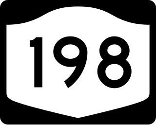
New York State Route 198 (NY 198) is an expressway located entirely within the city of Buffalo, New York, in the United States. It is named the Scajaquada Expressway for Scajaquada Creek, which it covers as it heads across northern Buffalo. NY 198 connects the Niagara Thruway in the Black Rock neighborhood to the Kensington Expressway (NY 33) on Buffalo's east side, dividing the city's premier public park in half.
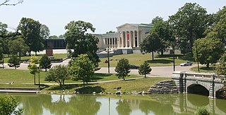
Delaware Park–Front Park System is a historic park system and national historic district in the northern and western sections of Buffalo in Erie County, New York. The park system was designed by Frederick Law Olmsted and Calvert Vaux and developed between 1868 and 1876.

New York State Route 384 (NY 384) is a state highway in Western New York in the United States. It is a north–south route extending from the city of Buffalo, Erie County to the city of Niagara Falls, Niagara County, and is one of several routes directly connecting the two cities. The southern terminus of the route is at NY 5 in downtown Buffalo. NY 384's northern terminus is at the Rainbow Bridge in downtown Niagara Falls. Through its entire course in Erie County, it is known as Delaware Avenue for the street it follows in the city. In Niagara County, NY 384 follows the Niagara River and is named River Road and Buffalo Avenue.
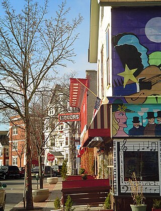
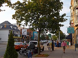
The Allentown district is a neighborhood in Buffalo, New York. The neighborhood is home to the Allentown Historic District.
Many of the public parks and parkways system of Buffalo, New York, were originally designed by Frederick Law Olmsted and Calvert Vaux between 1868 and 1896. They were inspired in large part by the parkland, boulevards, and squares of Paris, France. They include the parks, parkways and circles within the Cazenovia Park–South Park System and Delaware Park–Front Park System, both listed on the National Register of Historic Places and maintained by the Buffalo Olmsted Parks Conservancy.
Southwest Philadelphia is a section of Philadelphia, Pennsylvania, United States. The section can be described as extending from the western side of the Schuylkill River to the city line, with the SEPTA. The northern border is defined by the Philadelphia City Planning Commission as east from the city line along Baltimore Avenue moving south along 51st Street to Springfield Ave. It follows the train tracks until 49th Street. From 49th and Kingsessing Ave the line moves east along Kingsessing Ave. The line then moves south along 46th St to Paschall Ave where it jogs to join Grays Ferry where the line runs to the Schuylkill River.
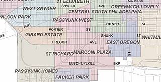
Marconi Plaza is an urban park square located in South Philadelphia, Philadelphia, Pennsylvania, United States. The plaza was named to recognize the 20th-century cultural identity in Philadelphia of the surrounding Italian-American enclave neighborhood and became the designation location of the annual Columbus Day Parade.

North Buffalo, is a neighborhood in the city of Buffalo, New York.
The Upper West Side is a neighborhood in Buffalo, New York.

Packer Park is a neighborhood in the South Philadelphia section of Philadelphia, Pennsylvania, United States that originally included 1,000 homes built in two unique builder developments, of Packer Park in the 1950s and Brinton Estates during the 1990s. It is now one of four residential communities to be designated as Packer Park. The original footprint community is also one of four adjacent communities that form Philadelphia's Sports Complex Special Services District. The approximate boundaries are Packer Avenue to the north, Hartranft Street to the south including FDR Park farther south, Broad Street to the east known as the Southern Parkway, and I-76 to the far west. Packer Park has been considered home to one of the most organized community groups in the South Philadelphia region.

James Addison Johnson was an American architect known for his design of various architectural landmarks in Buffalo, New York, and his use of decorative work that many consider a foreshadowing of art deco design.
Cazenovia Park–South Park System is a historic park system located in the South Buffalo neighborhood at Buffalo in Erie County, New York. The interconnected set of parkways and parks was designed by Frederick Law Olmsted as part of his parks plan for the city of Buffalo, as inspired in large part by the parkland, boulevards, and squares of Paris, France.
The Delaware District is a neighborhood in Buffalo, New York.
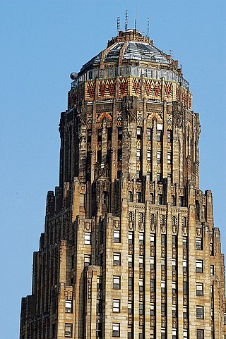
The Architecture of Buffalo, New York, particularly the buildings constructed between the American Civil War and the Great Depression, is said to have created a new, distinctly American form of architecture and to have influenced design throughout the world.

Elmwood Historic District–West is a national historic district located at Buffalo, Erie County, New York. The district encompasses 1,971 contributing buildings, 4 contributing structures, and 13 contributing objects in the Elmwood Village neighborhood of Buffalo. It is built around the Buffalo Parks and Parkways system bounded on the north by Delaware Park, Forest Lawn Cemetery, and the former Buffalo State Asylum, on the south by the Allentown Historic District, and on the east by the Elmwood Historic District–East. This predominantly residential district developed between about 1867 and 1941, and includes notable examples of Queen Anne, Shingle Style, Colonial Revival, Tudor Revival, and American Craftsman style architecture. The district contains one of the most intact collections of built resources from turn of the 20th century in the city of Buffalo and western New York State. Located in the district are six previously listed contributing resources including the Richmond Avenue Methodist-Episcopal Church and the Buffalo Tennis and Squash Club. Other notable building include the H.C. Gerber House (1908), the Fred Dullard House (1910), the William H. Scott House (1904), St. John's-Grace Episcopal Church designed by Bertram Grosvenor Goodhue (1925–26), Davidson House (1885), former Jehle Grocery Store and Residence, St. Luke's Episcopal Church, Temple Beth El, Richmond Avenue Church of Christ (now Bryant Parish Condominiums, and Pilgrim-St. Luke's United Church of Christ.