
Newfoundland and Labrador is the easternmost province of Canada, in the country's Atlantic region. The province comprises the island of Newfoundland and the continental region of Labrador, having a total size of 405,212 km2 (156,453 sq mi) As of January 1, 2024, the population of Newfoundland and Labrador was estimated to be 540,552. The island of Newfoundland is home to around 94 per cent of the province's population, with more than half residing in the Avalon Peninsula. Labrador borders the province of Quebec, and the French overseas collectivity of Saint Pierre and Miquelon lies about 20 km (12 mi) west of the Burin Peninsula.

Labrador is a geographic and cultural region within the Canadian province of Newfoundland and Labrador. It is the primarily continental portion of the province and constitutes 71% of the province's area but is home to only 6% of its population. It is separated from the island of Newfoundland by the Strait of Belle Isle. It is the largest and northernmost geographical region in the four Atlantic provinces.

Nunatsiavut is an autonomous area claimed by the Inuit in Newfoundland and Labrador, Canada. The settlement area includes territory in Labrador extending to the Quebec border. In 2002, the Labrador Inuit Association submitted a proposal for limited autonomy to the government of Newfoundland and Labrador. The constitution was ratified on December 1, 2005, at which time the Labrador Inuit Association ceased to exist, and the new Government of Nunatsiavut was established, initially being responsible for health, education and cultural affairs. It is also responsible for setting and conducting elections, the first of which was executed in October 2006. An election for the ordinary members of the Nunatsiavut Assembly was held on May 4, 2010. Its incumbent president is Johannes Lampe who assumed office in 2016.

Nain is the northernmost permanent settlement in the Canadian province of Newfoundland and Labrador, within the Nunatsiavut region, located about 370 km (230 mi) by air from Happy Valley-Goose Bay. The town was established as a Moravian mission in 1771 by Jens Haven and other missionaries. As of 2021, the population is 1,204 mostly Inuit and mixed Inuit-European. Nain is the administrative capital of the autonomous region of Nunatsiavut.
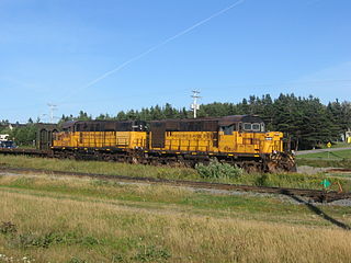
The Wabush Lake Railway is a short line railway operating in the province of Newfoundland and Labrador, Canada.

Happy Valley-Goose Bay is a town in the province of Newfoundland and Labrador, Canada.
Tshiuetin Rail Transportation Inc. is a rail company that owns and operates a 217-kilometre (135 mi) Canadian regional railway that stretches through the wilderness of western Labrador and northeastern Quebec. It connects Emeril, Labrador with Schefferville, Quebec, on the interprovincial boundary. The company also operates a 356-kilometre (221 mi) railway that connects Sept-Îles, Quebec to Emeril. The company is the first railway in North America owned and operated by Indigenous peoples, specifically by the Innu Nation of Matimekush-Lac John, the Naskapi Nation of Kawawachikamach, and the Innu Takuaikan Uashat Mak Mani-Utenam.
Purcell's Harbour is a local service district and designated place in the Canadian province of Newfoundland and Labrador. It is on the southern Twillingate island, about 4 km (2.5 mi) outside the town of Twillingate, near the community of Little Harbour.
Herring Neck is a local service district and designated place in the Canadian province of Newfoundland and Labrador. It is on the northeastern extremity of New World Island, Notre Dame Bay. The community encompasses several small contiguous communities such as Merritt's Harbour, Hatchet Harbour, Salt Harbour, and Sunnyside.
O'Donnells is a local service district and designated place in the Canadian province of Newfoundland and Labrador. It is southeast of Placentia. The first postmistress was Mrs. Theresa M. Hanlon on July 16, 1951. By 1956 there was a population of 244.

Francois is a local service district and designated place in the Canadian province of Newfoundland and Labrador. It is located on the southern coast of Newfoundland on François Bay at the end of a small fjord. There is a general store, a post office and a small museum, accessed by concrete pathways and boardwalks. Most residents pronounce the name "Fran-sway", and its proper spelling is without the cedilla found in the French word françois.
William's Harbour is a former local service district and designated place in the Canadian province of Newfoundland and Labrador. The community was entirely resettled in 2017. The settlement was part of the NunatuKavut territory.

La Poile is a local service district and designated place in the Canadian province of Newfoundland and Labrador. It is on La Poile Bay. The community is inaccessible by road and is served by a ferry via a port in Rose Blanche.
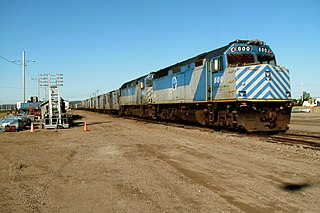
The Quebec North Shore and Labrador Railway is a private Canadian regional railway that stretches 414 kilometres (257 mi) through the wilderness of northeastern Quebec and western Labrador. It connects Labrador City, Labrador, with the port of Sept-Îles, Quebec, on the north shore of the St. Lawrence River. QNS&L is owned by Iron Ore Company of Canada (IOC), and is a common carrier.
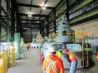
The Menihek Hydroelectric Generating Station is a conventional hydroelectric generating station at Menihek Lake in Labrador. The dam and powerhouse are located in the Canadian province of Newfoundland and Labrador, 40 km (25 mi) south of the isolated town of Schefferville, Quebec and two First Nations communities: Matimekosh-Lac-John and Kawawachikamach. The generating station, two 69 kV power lines and the distribution networks in each community form an independent electricity network, off the main North American grid.
Bear Cove is a local service district and designated place in the Canadian province of Newfoundland and Labrador on the northern peninsula of the island of Newfoundland.

South Dildo is a local service district and designated place in the Canadian province of Newfoundland and Labrador.

