Plaquemines Parish is a parish located in the U.S. state of Louisiana. With a population of 23,515 at the 2020 census, the parish seat is Pointe à la Hache and the largest community is Belle Chasse. The parish was formed in 1807.

Shenandoah is an unincorporated area and census-designated place (CDP) in East Baton Rouge Parish, Louisiana, United States. It is part of the Baton Rouge Metropolitan Statistical Area. The population was 18,399 at the 2010 census, up from 17,070 in 2000. Shenandoah consists of a number of residential subdivisions, including Shenandoah Estates, Shenandoah Park, White Oak Landing, White Oak Estates, The Woods and The Lake at White Oak.

Plaquemine is a city in and the parish seat of Iberville Parish, Louisiana, United States. It is part of the Baton Rouge metropolitan statistical area. At the 2010 United States census, the population was 7,119; the 2020 census determined its population was 6,269.

Jefferson is a census-designated place (CDP) in Jefferson Parish, Louisiana, United States, on the north side of the Mississippi River. Jefferson is part of the New Orleans–Metairie–Kenner metropolitan statistical area. The population was 11,193 at the 2010 census, and 10,533 in 2020. It is often known by locals as "Old Jefferson", but should not be confused with Old Jefferson in East Baton Rouge Parish, Louisiana.
Terrytown is an unincorporated community and census-designated place (CDP) in Jefferson Parish, Louisiana, United States. It is on the "Westbank" of the Mississippi River. It is a suburb within the New Orleans–Metairie–Kenner metropolitan statistical area. The population was 23,319 at the 2010 census, and 25,278 in 2020.
Woodmere is an unincorporated community and census-designated place (CDP) in Jefferson Parish, Louisiana, United States. The population was 12,080 at the 2010 census, and 11,238 at the 2020 census. It is part of the New Orleans–Metairie–Kenner metropolitan statistical area.

Belle Chasse is a census-designated place (CDP) in Plaquemines Parish, Louisiana, United States, on the west bank of the Mississippi River. Belle Chasse is part of the Greater New Orleans metropolitan area. The population was 10,579 at the 2020 United States census. Belle Chasse is the largest community in Plaquemines Parish. It is home to Naval Air Station Joint Reserve Base New Orleans, a Naval Air Station for the U.S. Navy Reserve.
Boothville-Venice is a former census-designated place (CDP) in Plaquemines Parish, Louisiana, United States, which includes the unincorporated communities of Boothville, Venice, and Orchard. The population was 2,220 at the 2000 census. For the 2010 census, Boothville-Venice was split into the CDPs of Boothville and Venice.
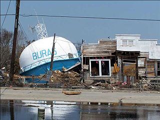
Buras-Triumph is a former census-designated place in Plaquemines Parish, Louisiana, United States. The population was 3,358 at the 2000 census. For the 2010 census, Buras-Triumph was split into the CDPs of Buras and Triumph. On the peninsula, Buras has been located higher, with Triumph located southeast of Buras.

Port Sulphur is a census-designated place (CDP) on the West Bank of the Mississippi River in Plaquemines Parish, Louisiana, United States; at the 2020 census, it had a population of 1,677.

Meraux is a census-designated place (CDP) in St. Bernard Parish, Louisiana, United States. The population was 6,804 in 2020. It is part of the New Orleans–Metairie–Kenner Metropolitan Statistical Area.

Poydras is a census-designated place (CDP) in St. Bernard Parish, Louisiana, United States. The population was 3,886 at the 2000 census and 2,536 in 2020. It is part of the New Orleans–Metairie–Kenner Metropolitan Statistical Area. Poydras is on the East Bank of the Mississippi River, just upriver from the Plaquemines Parish line.

Des Allemands is an unincorporated community and census-designated place (CDP) in Lafourche and St. Charles parishes in the southeastern part of the U.S. state of Louisiana. The population was 2,179 at the 2020 census. The town, known as the "Catfish Capital of the Universe", is along the Bayou des Allemands, which is the boundary of Lafourche and St. Charles parishes. Lac des Allemands is located northwest of the town. The ZIP Code for Des Allemands is 70030.
Venice is an unincorporated community and census-designated place in Plaquemines Parish, Louisiana, United States. As of the 2020 census, its population was 162. It is 77 miles (124 km) south of New Orleans on the west bank of the Mississippi River at 29°16′37″N89°21′17″W. It is the last community down the Mississippi accessible by automobile, and it is the southern terminus of the Great River Road. This has earned the town the nickname "The end of the world." The ZIP code for Venice is 70091.
Boothville is an unincorporated community and census-designated place in Plaquemines Parish, Louisiana, United States. Its population was 854 as of the 2010 census, and 718 at the 2020 U.S. census.
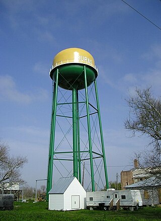
Buras is a census-designated place (CDP) in Plaquemines Parish, Louisiana, United States. Its population was 945 at the 2010 census, and 1,109 in 2020. Prior to the 2010 census, Buras was considered to be part of the Buras-Triumph CDP.
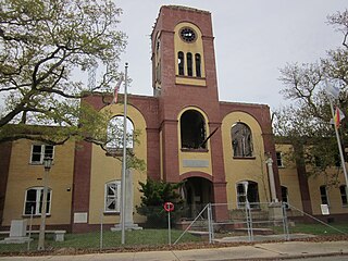
Pointe à la Hache is a census-designated place (CDP) and unincorporated community in Plaquemines Parish, Louisiana, United States. Located on the east bank of the Mississippi River, the village has been the seat for Plaquemines Parish since the formation of the parish. As of the 2020 census, its population was 183, less than half its 1930 population. It suffered severe damage from Hurricane Katrina in 2005 and Tropical Storm Lee in 2011.

Triumph is an unincorporated community and census-designated place in Plaquemines Parish, Louisiana, United States. It is located on the south bank of the Mississippi River. As of the 2020 census, its population was 268.
South Plaquemines High School (SPHS) is a grade 7–12 junior and senior high school in Empire, a census-designated place in Plaquemines Parish, Louisiana; the school has a Buras postal address. A part of Plaquemines Parish School Board, it serves Boothville, Buras, Empire, Port Sulphur, and Venice. In 2006 Jeré Longman of The New York Times described South Plaquemines High as "one of Louisiana’s smaller high schools".
Crescent is an unincorporated community and census-designated place in Iberville Parish, Louisiana, United States. It was first listed as a CDP in the 2010 Census with a population of 959. In 2020, its population was 811.


