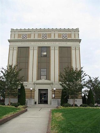
Person County is a county located in the U.S. state of North Carolina. The population was 39,097 as of the 2020 census. The county seat is Roxboro.

Orange County is a county located in the Piedmont region of the U.S. state of North Carolina. As of the 2020 census, the population was 148,696. Its county seat is Hillsborough. Orange County is included in the Durham-Chapel Hill, NC Metropolitan Statistical Area, which is also included in the Raleigh-Durham-Cary, NC Combined Statistical Area, which had an estimated population of 2,368,947 in 2023. It is home to the University of North Carolina at Chapel Hill, the flagship institution of the University of North Carolina System and the oldest state-supported university in the United States.
Halifax County is a county located in the U.S. state of North Carolina. As of the 2020 census, the population was 48,622. Its county seat is Halifax.

Durham County is a county located in the U.S. state of North Carolina. As of the 2020 census, the population was 324,833, making it the sixth-most populous county in North Carolina. Its county seat is Durham, which is the only incorporated municipality predominantly in the county, though very small portions of cities and towns mostly in neighboring counties also extend into Durham County. The central and southern parts of Durham County are highly urban, consisting of the city as well as several unincorporated suburbs. Southeastern Durham County is dominated by the Research Triangle Park, most of which is in Durham County. The northern third of Durham County is rural in nature. Durham County is the core of the Durham-Chapel Hill, NC Metropolitan Statistical Area, which is also included in the Raleigh-Durham-Cary, NC Combined Statistical Area, which had an estimated population of 2,368,947 in 2023.

Scouting in North Carolina has a long history, from the 1910s to the present day, serving thousands of youth in programs that suit the environment in which they live.

The town of Hillsborough is the county seat of Orange County, North Carolina, United States and is located along the Eno River. The population was 6,087 in 2010, but it grew rapidly to 9,660 by 2020.

The Research Triangle, or simply The Triangle, are both common nicknames for a metropolitan area in the Piedmont region of the U.S. state of North Carolina. Anchored by the cities of Raleigh and Durham and the town of Chapel Hill, the region is home to three major research universities: North Carolina State University, Duke University, and the University of North Carolina at Chapel Hill, respectively. The "Triangle" name originated in the 1950s with the creation of Research Triangle Park located between the three anchor cities, which is the largest research park in the United States and home to numerous high tech companies.
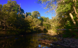
Eno River State Park is a 4,319-acre (17.48 km2) North Carolina state park in Durham and Orange Counties, North Carolina. Together with the adjoining West Point on the Eno city park, the two parks preserve over 14 miles (22.5 km) of the Eno River and surrounding lands.

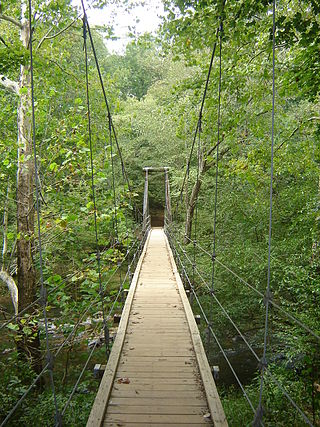
Occoneechee Mountain State Natural Area is a North Carolina state park in Orange County, North Carolina in the United States. Located adjacent to the town of Hillsborough, it covers 221 acres (0.89 km2) and includes Occoneechee Mountain, the highest point (867 ft) in Orange County and a settlement of the Occaneechi tribe.
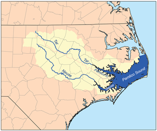
The Neuse River is a river rising in the Piedmont of North Carolina and emptying into Pamlico Sound below New Bern. Its total length is approximately 275 miles (443 km), making it the longest river entirely contained in North Carolina. The Trent River joins the Neuse at New Bern. Its drainage basin, measuring 5,630 square miles (14,600 km2) in area, also lies entirely inside North Carolina. It is formed by the confluence of the Flat and Eno rivers prior to entering the Falls Lake reservoir in northern Wake County. Its fall line shoals, known as the Falls of the Neuse, lie submerged under the waters of Falls Lake. This River also creates the beauty of the Neuse River Trail, a 34.5 miles (55.5 km) long greenway that stretches from Falls Lake Dam, Raleigh, North Carolina to Legend Park, Clayton, North Carolina.

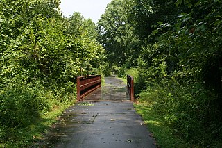
The Mountains-to-Sea State Trail (MST) is a long-distance trail in the US for hiking and backpacking, that traverses North Carolina from the Great Smoky Mountains to the Outer Banks. Its western endpoint is at Kuwohi, where it connects to the Appalachian Trail in the Great Smoky Mountains National Park. Its eastern endpoint is in Jockey's Ridge State Park on the tallest sand dune on the east coast. The trail is envisioned as a scenic backbone of an interconnected trail system spanning the state. As such, its route attempts to connect as many trail systems and natural scenic areas as practicable. A little over half of the trail is complete in multiple segments across the state.
Ellerbe Creek is a tributary of the Neuse River in North Carolina, USA. It is part of the Neuse River Basin, and flows for more than twenty miles through North Durham. The Ellerbe's watershed begins near Orange County north of Interstate 85, near the WDNC radio tower and Bennett Place. The creek flows through many of Durham's most historic and culturally significant areas, including Ninth Street, Downtown Durham, beneath Durham Athletic Park, The North Carolina School of Science and Mathematics, the Museum of Life and Science, the old Durham Landfill, Duke University East Campus, Trinity Park, Walltown, Northgate Mall, and towards the end crosses Fishdam Road. The Ellerbe eventually flows into Falls Lake, about a mile south of the Eno River.

Occoneechee Speedway was one of the first two NASCAR tracks to open. It closed in 1968 and is the only dirt track remaining from the inaugural 1949 season.
William Churton was an early North Carolina surveyor.

North Carolina Highway 157 (NC 157) is a 29.3-mile-long (47.2 km) primary state highway in the U.S. state of North Carolina. The highway runs in a north–south direction from Interstate 85 (I-85), U.S. Route 15 (US 15), US 70, and US 501 in Durham, to US 158, US 501, and NC 57 in Roxboro. The highway serves the cities of Durham and Roxboro, along with the communities of Caldwell and Hurdle Mills. NC 157 is named Guess Road between its southern terminus and Hurdle Mills, and Hurdle Mills Road between Hurdle Mills and the Roxboro city limits. NC 157 does not directly parallel US 501, however, the two highways generally follow a similar alignment between Durham and Roxboro. NC 157 serves the counties of Durham, Orange, and Person.
The Occoneechee Council (421) of the Boy Scouts of America serves some 8,200 youths and 4,600 adults in central North Carolina, US. The Occoneechee Council is the largest Boy Scout council in North Carolina and serves Chatham, Cumberland, Durham, Franklin, Granville, Harnett, Lee, Moore, Orange, Vance, Wake and Warren counties. These twelve counties are divided into four districts. Besides providing administrative support for Scout troops in their council area, they also maintain three large campgrounds.
James Innes was an American military commander and political figure in the Province of North Carolina who led troops both at home and abroad in the service of the Kingdom of Great Britain. Innes was given command of a company of North Carolina's provincial soldiers during the War of Jenkins' Ear, and served as Commander-in-Chief of all colonial soldiers in the Ohio River Valley in 1754 during the French and Indian War. After resigning his commission in 1756, Innes retired to his home on the Cape Fear River. A bequest made by Innes upon his death led to the establishment of Innes Academy in Wilmington, North Carolina.

Lipscomb House, or Lipscombe House, is a historic Federal-style plantation house in Durham, North Carolina, United States. The Lipscomb Plantation, sitting on 2,000 acres between the Eno River and the Little River, was one of the largest forced-labor cotton farms in Durham County. The plantation was part of the Trading Path, used by Catawba and Waxhaw Native American tribes trading between Petersburg, Virginia, and Hillsborough, North Carolina. The house is now run as a bed and breakfast.

Poplar Hill is a historic plantation house in Hillsborough, North Carolina. The home was the center of a large plantation, formerly called Occoneechee Farm and Banks of the Eno. Established on farming and hunting grounds for the Occaneechi and Saponi peoples, the land was granted to colonist Francis Corbin by the English and made into a working plantation. Ownership later passed to the Hogg family before the farm was purchased in 1891 by tobacco industrialist and white supremacist Julian Carr. Carr and his wife had the original 1794 plain farmhouse redone in the Greek Revival style. After Carr's death, the house was moved from its original location to a new lot in the Hillsborough Historic District. Poplar Hill later became a rental property and, in the twenty-first century, many tenants, including the singer Tom Maxwell, have broken their leases due to reported hauntings on the property.
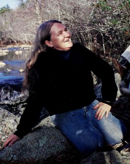
Margaret Nygard was a British-American environmentalist and conservationist. Born in British India to a civil servant, she was educated in both India and Britain. During the 1940 and 1941 bombing campaign against Britain, her school was relocated to British Columbia, Canada. Nygard studied English at the University of British Columbia and after her graduation in 1944 briefly became a teacher at the university. She went on to earn a master's degree and a PhD from the University of California, Berkeley. In 1962, she and her family moved to Durham, North Carolina, and became aware of environmental threats to the Eno River. She founded the Eno River Association in 1965, becoming its first president. She naturalised as a United States citizen in 1993.