Epping Rural District

Last updated

Epping
Epping RD 1911.png
The district in 1911
Area
  191139,055 acres (158.05 km2)
  195134,851 acres (141.04 km2)
Population
  190112,783
  195120,024
History
  Created1894
  Abolished1955
  Succeeded by Harlow Urban District
Epping and Ongar Rural District
Status Rural district
   HQ Epping

Epping was, from 1894 to 1955, a rural district in the administrative county of Essex, England. [1] [2]

Contents

Formation and boundary changes

The district was formed by the Local Government Act 1894 as successor to the Epping Rural Sanitary District. The rural district was governed by a directly elected rural district council (RDC), which replaced the rural sanitary authority that had comprised the poor law guardians for the area. The council's headquarters were in the town of Epping.

Over its existence, the rural district lost territory to new urban districts. In 1896 Epping became a separate urban district, although Epping RDC continued to be based in the town. Loughton and Chigwell were constituted urban districts in 1900 and 1933 respectively. [1]

Abolition

Epping RD was finally abolished when the New Town of Harlow was constituted an urban district in 1955. The remainder of the rural district was merged with the neighbouring Ongar Rural District to form Epping and Ongar Rural District. [1]

Parishes

When established in 1894, Epping RD consisted of sixteen civil parishes. Over the next sixty-one years the number was reduced due to both loss of territory to urban districts and amalgamation of small parishes. On abolition there were twelve parishes: [1]

ParishNotes
Chigwell Became a separate urban district in 1933
Epping Most became a separate urban district in 1896, part constituted as Epping Upland parish
Epping Upland Created 1896 from the part of Epping not included in urban district. Part included in Harlow UD 1955.
Great Parndon Part included in Harlow UD 1955.
Harlow Was enlarged to become Harlow Urban district in 1955.
Latton Abolished 1949 with area split between Harlow and North Weald Bassett
Little Parndon Absorbed by Netteswell parish in 1949
Magdalen Laver
Loughton Became a separate urban district in 1900
Matching
Nazeing
Netteswell Part included in Harlow UD 1955.
North Weald Bassett
Roydon Part included in Harlow UD 1955.
Sheering
Theydon Bois
Theydon Garnon

Related Research Articles

<span class="mw-page-title-main">Rural district</span> Former type of local government area in England, Wales, and Ireland

Rural districts were a type of local government area – now superseded – established at the end of the 19th century in England, Wales, and Ireland for the administration of predominantly rural areas at a level lower than that of the administrative counties.

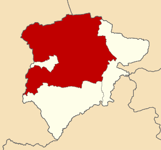
Epping and Ongar Rural District was a rural district in the county of Essex, England from 1955 to 1974.

<span class="mw-page-title-main">Municipal Borough of Chingford</span>

Chingford was a local government district in south west Essex, England from 1894 to 1965, around the town of Chingford. It was within the London suburbs, forming part of the London postal district and Metropolitan Police District. Its former area now corresponds to the northern part of the London Borough of Waltham Forest in Greater London.

<span class="mw-page-title-main">Oakham Rural District</span>

Oakham was a rural district in Rutland, England from 1894 to 1974, covering the north of the county.

<span class="mw-page-title-main">Ampthill Rural District</span> History of Bedfordshire

Hemsworth was, from 1894 to 1974, a rural district in the West Riding of Yorkshire, England.

Romford Rural District was a local government district in southwest Essex, England from 1894 to 1934. It surrounded, but did not include, Romford which formed a separate urban district. During the life of the district the area changed in use from rural farm land to sprawling London suburb and in 1926 much of it was removed to form new urban districts.

<span class="mw-page-title-main">Staines Rural District</span>

Staines Rural District was a rural district of Middlesex in England from 1894 to 1930.

Ongar is a civil parish in the Epping Forest District in Essex, England. Other than the town of Chipping Ongar it also includes Greensted, Greensted Green, Marden Ash and Shelley. The local council of the parish is Ongar Town Council. Located approximately 21 miles north-east of London, it is a partially developed parish with large sections of open land.

<span class="mw-page-title-main">Ongar Rural District</span>

Ongar Rural District was a local government district in Essex, England from 1894 to 1955. It included the small town of Chipping Ongar and the parishes surrounding it.

<span class="mw-page-title-main">Campden Rural District</span>

<span class="mw-page-title-main">Pebworth Rural District</span>

References

  1. 1 2 3 4 Youngs, Frederic A Jr. (1979). Guide to the Local Administrative Units of England, Vol.I: Southern England. London: Royal Historical Society. p. 603. ISBN   0-901050-67-9.
  2. Vision of Britain – Epping RD (historic map Archived 1 October 2007 at the Wayback Machine )

51°43′N0°05′E / 51.72°N 0.08°E / 51.72; 0.08