
Epping Forest is a local government district in Essex, England. Situated in the west of the county, bordering northeastern Greater London, it is named after, and contains a large part of, Epping Forest.

The Borough of Brentwood is a local government district and borough in Essex in the East of England.

Chigwell was a local government district in south west Essex, England. It contained the settlements of Chigwell, Loughton and Buckhurst Hill; and formed part of the Metropolitan Police District.

Chipping Ongar is a market town and former civil parish, now in the parish of Ongar, in the Epping Forest District of the county of Essex, England. It is located 6 miles (10 km) east of Epping, 7 miles (11 km) southeast of Harlow and 7 miles (11 km) northwest of Brentwood. In 2020 the built-up area had an estimated population of 6420. In 1961 the parish had a population of 1673.
Epping and Ongar Rural District was a rural district in the county of Essex, England from 1955 to 1974.

The Epping Ongar Railway is a heritage railway in south-west Essex, England, run by a small number of paid staff and a team of volunteers. It was the final section of the Great Eastern Railway branch line, later the London Underground's Central line from Loughton via Epping to Ongar, with intermediate stations at North Weald and Blake Hall. The line was closed by London Underground in 1994 and sold in 1998. It reopened between 2004 and 2007 as a preserved railway, offering a volunteer-run Class 117 DMU service between Ongar and Coopersale. A change of ownership in 2007 led to the line being closed for restoration to a heritage steam railway, which opened on 25 May 2012.

Epping is a London Underground station in the market town of Epping in Essex, England. The station serves as the north-eastern terminus of the Central line. Located in Travelcard Zone 6, it is one of eight London Underground stations in the Epping Forest District. The station before Epping is Theydon Bois, which is about three minutes' travelling time away.
Harlow is a constituency represented in the House of Commons of the UK Parliament since 2010 by Robert Halfon, a Conservative.

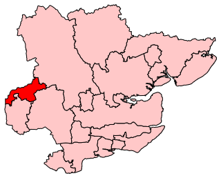
Brentwood and Ongar is a constituency represented in the House of Commons of the UK Parliament since 2017 by Alex Burghart, a Conservative, serving since September 2021 as Parliamentary Under-Secretary of State for Apprenticeships and Skills.

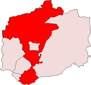
Epping Forest is a constituency represented in the House of Commons of the UK Parliament since 1997 by Eleanor Laing, a Conservative.

The Rodings are a group of eight villages in the upper part of the River Roding and the west of Essex, England, the largest group in the country to bear a common name. The Rodings do not lie within a single district in the county; they are arranged around the tripoint of the administrative areas of Chelmsford, Uttlesford and Epping Forest. An alternative arcane name, linked to the Middle English Essex dialect, was The Roothings.

Stapleford Abbotts is a village and civil parish in the Epping Forest district of Essex, approximately 5.5 mi (9 km) SW of Ongar, 4.5 mi (7 km) N of Romford and 5 mi (8 km) SSE of Epping. The whole parish is within the M25 motorway. The village covers 957 hectares and had a population of 959 in 2001, increasing to 1,008 at the 2011 Census.

Epping was a parliamentary constituency represented in the House of Commons of the UK Parliament from 1885 to 1974. It elected one Member of Parliament (MP) by the first past the post system of election.
Chigwell was a parliamentary constituency represented in the House of Commons of the Parliament of the United Kingdom from 1955 to 1974. It elected one Member of Parliament (MP) by the first past the post system of election.

North Weald Bassett or simply North Weald is a village and civil parish in the Epping Forest district of Essex, England. The village is within the North Weald Ridges and Valleys landscape area.

Stapleford Tawney is a village and civil parish in the Epping Forest district of Essex, England. Stapleford Tawney is approximately 4 miles (6 km) west-southwest from Chipping Ongar and 14 miles (23 km) southwest from the county town of Chelmsford.
Ongar is a civil parish in the Epping Forest District in Essex, England. Other than the town of Chipping Ongar it also includes Greensted, Greensted Green, Marden Ash and Shelley. The local council of the parish is Ongar Town Council. Located approximately 21 miles north-east of London, it is a partially developed parish with large sections of open land.
Epping was, from 1894 to 1955, a rural district in the administrative county of Essex, England.

Lambourne is a civil parish in the Epping Forest district of Essex, England. It is located approximately 4.5 miles (7 km) South of Epping and 5 miles (8 km) northwest of Romford. It covers an area of 2,590 acres (1,050 ha), and in 2001 its population was 1,828, increasing to 2,013 at the 2011 Census.

Toot Hill is a village in the Stanford Rivers civil parish in the Epping Forest district of Essex, England. It is 2.3 miles (4 km) south-west of Chipping Ongar and 3.5 miles (6 km) east of Epping. Toot Hill is less than a mile from the small hamlet of Clatterford End.
