Essex Skypark

Last updated
Essex Airpark
Summary
Airport typePublic
OwnerBaltimore County
OperatorEssex Skypark Association
Serves Essex, Maryland
LocationEssex, MD
Elevation  AMSL 14 ft ft / 4 m m
Coordinates 39°15.76′N76°25.98′W / 39.26267°N 76.43300°W / 39.26267; -76.43300
Website http://www.essexskyparkassn.org
Map
USA Maryland location map.svg
Airplane silhouette.svg
W48
Location of airport in Maryland
Runways
Direction LengthSurface
ftm
16/342,081634Asphalt
N/S3,000914Water
Statistics (2023)
Aircraft operations (year ending 10/10/2023)5,592
Based aircraft33
Essex SkyPark W48 Logo.png

Essex Skypark( IATA : W48) is a publicly owned general aviation airport and seaplane base located in Baltimore County, Maryland, United States, on the Back River Neck Peninsula off the Chesapeake Bay. It is approximately three miles southeast of Baltimore, Maryland and just south of Martin State Airport.

Contents

Facilities

Airfield diagram Essex Skypark-DIR 2011.jpg
Airfield diagram

The 56 acre airport is surrounded by 588 acres of undisturbed and pristine wetlands and heavy forest. As the last light general aviation airport in Baltimore County, the airpark offers a 2,081 by 30 foot asphalt runway and a 3,000 by 300 foot water runway. Local aviation enthusiasts use it to fly single engine airplanes, ultralights, seaplanes, banner towing, and radio controlled aircraft. [3]

Essex Skypark has been an operating public use airport for over 75 years.

Early history

1946 USGS topo map incorrectly labels the airport as "Diffendall." Essex MD 47sect.JPG
1946 USGS topo map incorrectly labels the airport as "Diffendall."

Aviation enthusiast William Diffendahl carved the airpark out of local farmland in the late 1930s and early 1940s. It was used by aviation enthusiasts from the working communities around the Baltimore Glenn L. Martin Company plant that built the Martin M-130 flying boat, the Martin B-26 Marauder bomber and other aircraft in the 1940s.

A 1947 Maryland Airport Directory listed the airport as having two intersecting grass runways: a north–south strip 2,200 feet in length and an east–west strip 1,800 feet in length. Buildings on the airport (which was owned and operated by Isabelle Diffendahl) included an administration building, a 44-foot by 60-foot hangar as well as eight t-hangars.

The early years were very good to the airport, with more than 200 pilots calling the field their homeport. These pilots included crop dusters, air traffic reporters, traveling salesmen, daredevils and more. [4]

Sometime around 1949 the land was purchased by J. S. Shapiro and renamed Eastern Airport. The airport continued to flourish and prosper throughout the 1950s and 1960s, adding a seaplane base on adjacent Back River. By 1964, the longer of the two turf runways was paved and taxiways were added.

In 1967 the airport was renamed Essex Skypark. Many factors led to a decline in growth and revenues in the following years. By the 1970s however, things had stabilized. [5]

Recent history

In April 2000, using money from the Maryland Rural Legacy Program, Baltimore County bought the airport and surrounding 588 acres from the Shapiro Family for about $2.6M. The property came with a Maryland Environmental Trust [6] easement that called for protecting the forest and wetlands and provided for the continued operation and use of the existing airport. Many different uses have been suggested for the site's future, such as creating a forest mitigation park to offset development elsewhere in the county, to a Chesapeake Wildlife Sanctuary and environmental research facility for Johns Hopkins University and the University of Maryland. In 2006, Baltimore County accepted a grant from the Maryland Aviation Administration to repave the runway, taxiways, and apron along with a 15-year commitment to keep the airport. [5]

On 10 April 2012, the Essex Skypark Association [7] purchased a 99-year lease for the 44 acre airfield and associated seaplane base on the Back River from Baltimore County. The Association assumed all responsibility for maintaining and operating the airfield under the terms of the lease. [8]

A branch of the Civil Air Patrol and a model airplane club also use the facility. The lease allows the Association to host three public events or fly-ins a year, one of which is a "Wings & Wheels Fly-In" held every September that is open to the public.

Essex Skypark is home to a number of antique and experimental amateur built aircraft in addition to more modern aircraft. The Chesapeake Model Aircraft Association members fly their model aircraft from a small runway at the airport.

The airport is also the host for the Essex Skypark Science, Technology, Engineering and Mathematics (ESSTEM) Aviation Training Program. This is a approved 501.C.3 tax exempt non-profit (DLN 26053406002910) organization. The purpose of the ESSTEM is to provide base level aviation related education and skills training to young adults that desire to pursue a career in the aviation field. Educational programs include flight simulation training, hands on aircraft maintenance skills training, aviation seminars and one-on-one mentoring.

Related Research Articles

<span class="mw-page-title-main">Quad Cities International Airport</span> Airport in Moline, Illinois, United States

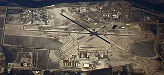
Quad Cities International Airport is a public airport in Rock Island County, Illinois, three miles (5 km) south of Moline, partly in Blackhawk Township and partly in Coal Valley Township. In 2012 it was named "Illinois Primary Airport of the Year". It serves the Quad Cities Metropolitan area, including Davenport and Bettendorf in Scott County, Iowa as well as Moline in Rock Island County, Illinois.

<span class="mw-page-title-main">Palmdale Regional Airport</span> Joint public-military airport in Palmdale, California

Palmdale Regional Airport is an airport in Palmdale, California, United States. The city of Palmdale took over the airport at the end of 2013, managing it via the Palmdale Airport Authority. The airport currently does not have any scheduled passenger airline service.

<span class="mw-page-title-main">Martin State Airport</span> Airport in Middle River, Maryland

Martin State Airport is a joint civil-military public use airport located nine nautical miles east of the central business district of Baltimore, in Baltimore County, Maryland, United States. The facility is located within the census-designated place of Middle River on Maryland State Highway 150, near the intersection of Maryland State Highway 700. The Maryland Aviation Administration operates the airport on behalf of the Maryland Department of Transportation. MTN is a general aviation relief airport.

<span class="mw-page-title-main">Frederick Municipal Airport (Maryland)</span> Airport in Frederick, Maryland

Frederick Municipal Airport is a public airport located in the city of Frederick, in Frederick County, Maryland, United States. This airport is publicly owned by the City of Frederick.

<span class="mw-page-title-main">Salisbury Regional Airport</span> Airport in Maryland, U.S.

Salisbury-Ocean City: Wicomico Regional Airport, or, more succinctly Salisbury Regional Airport, is located in unincorporated Wicomico County, Maryland, 5 miles (8.0 km) southeast from downtown Salisbury, Maryland, United States. Salisbury is the largest metropolitan area of Maryland's Eastern Shore with a population of 405,803 in the metropolitan statistical area, and is centrally located on the Delmarva Peninsula.

<span class="mw-page-title-main">Guelph Airport</span> Airport in Guelph, Ontario

Guelph Airport is located in the southeastern part of Guelph/Eramosa at its border with Guelph in Ontario, Canada. It consists of two runways, 14/32 and 06/24. Although known to residents as the "Guelph Airport" or "Guelph Airpark", it is actually an aerodrome, being registered, and not certified, by Transport Canada.

<span class="mw-page-title-main">Winter Haven's Gilbert Airport</span> Airport

Winter Haven's Gilbert Airport is a city-owned, public-use airport located three nautical miles (6 km) northwest of the central business district of Winter Haven, a city in Polk County, Florida, United States. It is owned by the City of Winter Haven. It is also known as Winter Haven Regional Airport or Gilbert Field. Jack Browns Seaplane Base is located adjacent to the airport, connected by a taxiway.

<span class="mw-page-title-main">Oroville Municipal Airport</span> Airport in California, United States of America

Oroville Municipal Airport is a public airport located 3 miles (5 km) southwest of the city of Oroville in Butte County, California, United States.

<span class="mw-page-title-main">College Park Airport</span> Airport in College Park, Maryland

College Park Airport is a public airport located in the City of College Park, in Prince George's County, Maryland, United States. It is the world's oldest continuously operated airport. The airport is located south of Paint Branch and Lake Artemesia, east of U.S. Route 1 and the College Park Metro/MARC station and west of Kenilworth Avenue.

Washington Executive Airport, also known as Washington Executive Airpark or Hyde Field, was a public use general aviation airport located 2 miles (3.2 km) southwest of the central business district (CBD) of Clinton, in Prince George's County, Maryland, United States. The airport ceased operations on November 30, 2022, following a bankruptcy sale of the property.

<span class="mw-page-title-main">Montgomery County Airpark</span> Public airport in Montgomery County, Maryland, United States

Montgomery County Airpark is a U.S. public airport located three miles (5 km) northeast of the city of Gaithersburg, in Montgomery County, Maryland, United States.

Mathis Airport was a private airport located in unincorporated Forsyth County, Georgia, United States, about 5 miles (8.0 km) northwest of Suwanee in the northeastern part of metro Atlanta. The airport closed in October 2014.

Lawrence County Airpark is a public use airport located two nautical miles (3.7 km) west of the central business district of Chesapeake, a village in Lawrence County, Ohio, United States. It is publicly owned by Lawrence County Board of Commissioners. The airport lies across the Ohio River from Huntington, West Virginia.

Sonoma Skypark is a public-use airport located three nautical miles (6 km) southeast of the central business district of Sonoma, a city in Sonoma County, California, United States. It is privately owned by Sonoma Skypark, Inc.

<span class="mw-page-title-main">Coolidge Municipal Airport</span> Airport in Pinal County, Arizona

Coolidge Municipal Airport is a city-owned public airport 5 miles southeast of Coolidge, in Pinal County, Arizona, United States.

<span class="mw-page-title-main">Buckingham Field</span> Airport in near Fort Myers, Florida

Buckingham Field is a private-use airport located seven nautical miles (13 km) east of the central business district of Fort Myers, in Lee County, Florida, United States. It is privately owned by the Lee County Mosquito Control District. The Buckingham Air Park has deeded access to the airport.

Arthur Dunn Airpark is a public-use airport located 2 miles (3.2 km) northwest of the central business district of the city of Titusville in Brevard County, Florida, United States. The airport is publicly owned and is administered under the cognizance of the Titusville-Cocoa Airport Authority. The airport has one paved runway that is 2,961 feet in length and a turf runway that is 1,805 feet in length.

<span class="mw-page-title-main">Baltimore Municipal Airport</span> Airport near Baltimore, Maryland, US

Baltimore Municipal Airport is a former airport and United States Air Force airfield about 6 miles southeast of Baltimore, Maryland on an artificial peninsula. Construction began in 1929 with a seaplane base and was completed in 1941. It closed on 30 December 1960. The western half of the airport was within the city of Baltimore, whereas the eastern half was in Dundalk, in Baltimore County.

The Jefferson County Airpark is a full-service general aviation public airport near Steubenville, Ohio, U.S., part of the Pittsburgh Combined Statistical Area that serves small and mid-sized private, corporate and commercial traffic. The airport serves transients traveling to and from Eastern Ohio, the Northern Panhandle of West Virginia, and Western Pennsylvania (Pittsburgh). The airport founded in January 1948 by R. G. and Pauline Pier as Pier Airport.

<span class="mw-page-title-main">Baltimore Airpark</span> Airport

Baltimore Airpark, formerly Quinn Airport was an airport located in Perry Hall, Maryland, United States.

References

  1. FAA Airport Form 5010 for w48 PDF , effective April 18, 2024.
  2. http://www.gcr1.com/5010web/airport.cfm?Site=W48 at WikiMapia
  3. "Archived copy". Archived from the original on 2012-06-08. Retrieved 2012-01-15.{{cite web}}: CS1 maint: archived copy as title (link)
  4. ""Maryland Aloft" by Preston, Lanman, and Breilhan". Archived from the original on 2005-06-08. Retrieved 2012-01-15.
  5. 1 2 "Essex Skypark Adds to Area's Aviation Legacy" Ron Snyder, Essex-MiddleRiverPatch 25 Sept 2011)
  6. Maryland Environmental Trust
  7. Essex Skypark Association
  8. Aircraft Owners and Pilots Association (AOPA) (April 11, 2013). "Historic Baltimore airport to remain open for 99 years". AOPA News and Video Blog. Retrieved 29 December 2013.