Flamingo is the southernmost headquarters of Everglades National Park, in Monroe County, Florida, United States. Flamingo is one of the two end points of the 99-mile (159-km) Wilderness Waterway, and the southern end of the only road through the park from Florida City. It began as a small coastal settlement on the eastern end of Cape Sable on the southern tip of the Florida peninsula, facing Florida Bay. The actual town of Flamingo was located approximately 4+1⁄2 miles west of the current Flamingo campground area. All that remains of the former town are a few remnants of building foundations, and it is considered a ghost town.

Everglades National Park is an American national park that protects the southern twenty percent of the original Everglades in Florida. The park is the largest tropical wilderness in the United States and the largest wilderness of any kind east of the Mississippi River. An average of one million people visit the park each year. Everglades is the third-largest national park in the contiguous United States after Death Valley and Yellowstone. UNESCO declared the Everglades & Dry Tortugas Biosphere Reserve in 1976 and listed the park as a World Heritage Site in 1979, and the Ramsar Convention included the park on its list of Wetlands of International Importance in 1987. Everglades is one of only three locations in the world to appear on all three lists.

Chikee or Chickee is a shelter supported by posts, with a raised floor, a thatched roof and open sides. Chickees are also known as chickee huts, stilt houses, or platform dwellings. The chickee style of architecture—palmetto thatch over a bald cypress log frame—was adopted by Seminoles during the Second (1835–42) and Third (1855-58) Seminole Wars as U.S. troops pushed them deeper into the Everglades and surrounding territory. Before the Second Seminole War, the Seminoles had lived in log cabins. Similar structures were used by the tribes in south Florida when the Spanish first arrived in the 16th century. Each chickee had its own purpose and together they were organized within a camp-type community. Chickees were used for cooking, sleeping, and eating.

Gulf Islands National Seashore offers recreation opportunities and preserves natural and historic resources along the Gulf of Mexico barrier islands of Florida and Mississippi. The protected regions include mainland areas and parts of seven islands. Some islands along the Alabama coast were originally considered for inclusion, but none are part of the National Seashore.

Disney's Fort Wilderness Resort & Campground is a themed camping resort located in the Magic Kingdom Resort Area at the Walt Disney World Resort in the U.S. state of Florida. It officially opened on November 19, 1971. The resort is situated adjacent to Bay Lake, near Disney's Wilderness Lodge. It also formerly contained Disney's River Country, a water park which closed on November 2, 2001.

Perdido Key is an unincorporated community in Escambia County, Florida located between Pensacola, Florida and Orange Beach, Alabama.The community is located on and named for Perdido Key, a barrier island in northwest Florida and southeast Alabama. "Perdido" means "lost" in the Spanish and Portuguese languages. The Florida district of the Gulf Islands National Seashore includes the east end of the island, as well as other Florida islands. No more than a few hundred yards wide in most places, Perdido Key stretches some 16 miles (26 km) from near Pensacola to Perdido Pass Bridge near Orange Beach.
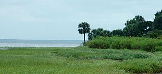
Cape Sable is the southernmost point of the United States mainland and mainland Florida. It is located in southwestern Florida, in Monroe County, and is part of the Everglades National Park.
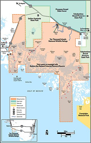
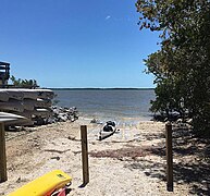
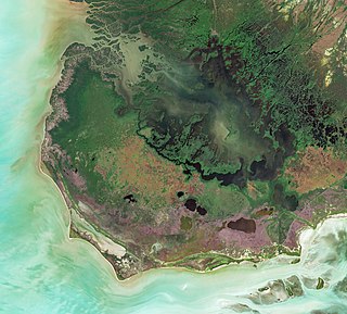
The Ten Thousand Islands are a chain of islands and mangrove islets off the coast of southwest Florida, between Cape Romano and the mouth of the Lostmans River. Some of the islands are high spots on a submergent coastline. Others were produced by mangroves growing on oyster bars. Despite the name, the islets in the chain only number in the hundreds.
St. Marks National Wildlife Refuge, in Wakulla County, Florida, is one of the oldest wildlife refuges in the United States. Established in 1931 as a wintering ground for migratory birds, it encompasses more than 83,000 acres spread between Wakulla, Jefferson, and Taylor Counties in the state of Florida.
Bahia Honda is an island in the lower Florida Keys.

The Mud Lake Canal is a prehistoric long-distance canoe canal near Flamingo, Florida, U.S. It is located at Cape Sable, in the Everglades National Park. At 3.9 miles (6.3 km), it is the longest of Florida's known prehistoric canals, believed to form a part of a sheltered travel route between the Florida Keys and the Ten Thousand Islands. On September 20, 2006, it was designated a National Historic Landmark and added to the U.S. National Register of Historic Places.
Dismal Key is a small island, part of the Ten Thousand Islands archipelago in the Gulf of Mexico off the coast of Florida. The island is artificial, constructed by people of the Glades culture. Construction of the island proceeded in stages over some 1,500 years following the end of the Archaic period in Florida. Occupation probably ended a couple of centuries before the arrival of Europeans in Florida. Dismal Key was occupied by several hermits in the 20th century.
Balsam Lake Provincial Park is a provincial park located in south-central Ontario on Balsam Lake. The park is situated along the Trent-Severn Waterway, a few kilometres southwest of Coboconk. It is an all-seasons recreation area offering camping, boating and fishing, and while closed in winter it is also used for skiing and snowshoeing.
The indigenous people of the Everglades region arrived in the Florida peninsula of what is now the United States approximately 14,000 to 15,000 years ago, probably following large game. The Paleo-Indians found an arid landscape that supported plants and animals adapted to prairie and xeric scrub conditions. Large animals became extinct in Florida around 11,000 years ago. Climate changes 6,500 years ago brought a wetter landscape. The Paleo-Indians slowly adapted to the new conditions. Archaeologists call the cultures that resulted from the adaptations Archaic peoples. They were better suited for environmental changes than their ancestors, and created many tools with the resources they had. Approximately 5,000 years ago, the climate shifted again to cause the regular flooding from Lake Okeechobee that gave rise to the Everglades ecosystems.

The Deptford culture was an archaeological culture in southeastern North America characterized by the appearance of elaborate ceremonial complexes, increasing social and political complexity, mound burial, permanent settlements, population growth, and an increasing reliance on cultigens.

Portland Island is an island of the Southern Gulf Islands of the South Coast of British Columbia, Canada. It is located in the Salish Sea west of Moresby Island and off the south tip of Saltspring Island, adjacent to the main BC Ferries route just offshore from the terminal at Swartz Bay at the tip of the Saanich Peninsula. It was named after HMS Portland, the flagship of Rear-Admiral Fairfax Moresby, Commander in Chief of the Pacific Station 1850–1853.
Plaskett is a thinly populated oceanside hamlet in Pacific Valley, a thin bench of land alongside the Big Sur Coast Highway in the southern Big Sur region of Monterey County, California. It lies at an elevation of 203 feet. It consists of a USFS campground and station, two small resorts, a small school, and a few dozen families spread over the general region.
High Adventure Bases of the Boy Scouts of America are outdoor recreation facilities located in several locales in North America operated by the Boy Scouts of America at the organization's national level. Each facility offers wilderness programs and training that could include wilderness canoeing, wilderness backpacking trips, or sailing, and provide opportunities for Scouts to earn the 50-Miler Award. These bases are administered by the High Adventure Division of the National Council of the Boy Scouts of America.

Poinciana was a planned community that was to be located along the Lostmans River in Monroe County, Florida. Poinciana has been described as the Everglades's "most spectacular commercial enterprise" and "the prototype of all Florida scams".