Flamingo, Monroe County, Florida

Last updated

Flamingo, Monroe County,
Florida
Flamingo Visitor Center FL1.jpg
Flamingo Visitor Center
USA Florida location map.svg
Red pog.svg
Flamingo
Location within the state of Florida
Usa edcp location map.svg
Red pog.svg
Flamingo
Flamingo (the United States)
Coordinates: 25°8′27″N80°55′27″W / 25.14083°N 80.92417°W / 25.14083; -80.92417
Country Flag of the United States.svg  United States
State Flag of Florida.svg  Florida
County Monroe
Time zone UTC-5 (Eastern (EST))
  Summer (DST) UTC-4 (EDT)

Flamingo is the southernmost headquarters of Everglades National Park, in Monroe County, Florida, United States. Flamingo is one of the two end points of the 99-mile (159-km) Wilderness Waterway (with another end point at Gulf Coast Visitor Center in the Everglades City), and the southern end of the only road (running 39.3 miles (63.2 km) [1] ) through the park from Florida City. It began as a small coastal settlement on the eastern end of Cape Sable on the southern tip of the Florida peninsula, facing Florida Bay. The actual town of Flamingo was located approximately 4+12 miles west of the current Flamingo campground area. All that remains of the former town are a few remnants of building foundations, and it is considered a ghost town. [2]

Contents

Flamingo Marina from the Florida Bay entrance. Salt/fresh water dam, kayak launch pad, slips, and ranger boats are visible. Flamingo Marina Visitor Center.jpg
Flamingo Marina from the Florida Bay entrance. Salt/fresh water dam, kayak launch pad, slips, and ranger boats are visible.
Flamingo Visitor Center Main Building Visitor-center.jpg
Flamingo Visitor Center Main Building

Early years

Flamingo was first settled circa 1892, although Tequesta Indians had lived in the area prior to that. The settlers made a living by providing fish, fresh vegetables and charcoal to Key West.

The settlement received its name in 1893 when the settlers had to choose a name for their new post office. They chose the flamingo as it was the most distinctive bird seen in the area. While the flamingo did not breed in Florida, birds from Cuba and the Bahamas once traveled in large numbers to the area. Flamingos were last seen in large numbers in the area in 1902. The post office closed in 1909. [3]

Leverett White Brownell, a naturalist, visited Flamingo in 1893. He described the village of 38 "shacks" on stilts as infested with fleas and mosquitoes. He claimed to have seen an oil lamp extinguished by a cloud of mosquitoes. He also stated that flea powder was the "staff of life" and that the cabins were thickly sooted from the use of smudge pots. He added that tomatoes, asparagus and eggplant were the principal crops. [4]

Flamingo had a small boom in the early 20th century when speculators thought that Henry Flagler would choose a route for his Florida East Coast Railway across Florida Bay to Key West. By 1900, about 50 families lived in Flamingo, and it had a Monroe County school. Nearby rookeries, such as the famed Cuthbert Rookery, became popular with poachers who sought to kill the nesting birds for their plumage, which was used for fashionable women's hats. Resident and early game warden Guy Bradley was shot and killed in Flamingo after confronting plume hunters. [5] Public rage over the murder directly led to federal legislation outlawing the practice.

A fish house was built in Flamingo in 1908 and fishing became the primary occupation of the town, but by 1910, only three homes remained occupied in Flamingo. The Ingraham Highway from Homestead reached Flamingo in 1922 but was poorly maintained and virtually impassable in wet weather until the National Park Service gave it a gravel top in the late 1940s. During Prohibition, moonshining became a major occupation in Flamingo but was eventually suppressed by government agents. [6]

The Snake Bight Trail provides an alternate pedestrian access to the sea to the east of Flamingo but its two-mile length is notorious for the number and ferocity of the mosquitoes. The Christian Point Trail is less daunting and leads through open saltwater marl prairie to Christian Point. [7] The area reportedly got its name when the Labor Day Hurricane of 1935 washed numerous dead bodies from the Keys ashore. [8]

Map of hurricane victims buried or cremated on Christian Point, 1935 Veterans Storm Relief Map - Christian Point.jpg
Map of hurricane victims buried or cremated on Christian Point, 1935

Geography

Climate

Flamingo experiences a tropical savanna climate (Köppen climate classification Aw) in which all twelve months have mean temperatures of at least 18 °C (64 °F). Summers are hot and humid and high temperatures average between 89° and 91 °F (31° to 33 °C). Winters are warm and dry.

Climate data for Flamingo, Florida, 19912020 normals, extremes 19512021
MonthJanFebMarAprMayJunJulAugSepOctNovDecYear
Record high °F (°C)95
(35)
94
(34)
89
(32)
95
(35)
96
(36)
98
(37)
100
(38)
101
(38)
101
(38)
99
(37)
95
(35)
92
(33)
101
(38)
Mean maximum °F (°C)83.2
(28.4)
85.4
(29.7)
86.1
(30.1)
89.1
(31.7)
91.0
(32.8)
93.3
(34.1)
93.9
(34.4)
94.4
(34.7)
93.3
(34.1)
90.6
(32.6)
87.5
(30.8)
84.6
(29.2)
95.5
(35.3)
Mean daily maximum °F (°C)76.3
(24.6)
78.4
(25.8)
80.6
(27.0)
83.7
(28.7)
86.7
(30.4)
89.1
(31.7)
90.2
(32.3)
90.5
(32.5)
89.3
(31.8)
86.7
(30.4)
82.0
(27.8)
78.3
(25.7)
84.3
(29.1)
Daily mean °F (°C)66.9
(19.4)
69.3
(20.7)
71.2
(21.8)
74.9
(23.8)
78.5
(25.8)
81.9
(27.7)
83.0
(28.3)
83.0
(28.3)
82.2
(27.9)
79.0
(26.1)
73.5
(23.1)
69.7
(20.9)
76.1
(24.5)
Mean daily minimum °F (°C)57.6
(14.2)
60.2
(15.7)
61.8
(16.6)
66.1
(18.9)
70.4
(21.3)
74.8
(23.8)
75.7
(24.3)
75.6
(24.2)
75.1
(23.9)
71.2
(21.8)
65.1
(18.4)
61.1
(16.2)
67.9
(19.9)
Mean minimum °F (°C)40.3
(4.6)
43.8
(6.6)
48.3
(9.1)
53.9
(12.2)
60.9
(16.1)
68.9
(20.5)
71.1
(21.7)
70.6
(21.4)
70.6
(21.4)
62.1
(16.7)
53.8
(12.1)
46.3
(7.9)
38.0
(3.3)
Record low °F (°C)27
(−3)
28
(−2)
33
(1)
43
(6)
48
(9)
56
(13)
62
(17)
63
(17)
60
(16)
41
(5)
36
(2)
25
(−4)
25
(−4)
Average precipitation inches (mm)1.73
(44)
1.61
(41)
1.56
(40)
2.49
(63)
3.62
(92)
7.05
(179)
6.32
(161)
6.80
(173)
7.18
(182)
4.41
(112)
2.36
(60)
1.66
(42)
46.79
(1,188)
Average precipitation days (≥ 0.01 in)6.95.54.84.97.513.114.514.715.310.96.27.0111.3
Source: NOAA [9] [10]

Flamingo today

The residents of Flamingo were relocated shortly after the creation of Everglades National Park. Through the second half of the 20th century Flamingo consisted of a restaurant and cafe, a gas station, a marina, a store, a gift shop, a campground, and a few houses for park rangers. In 1959, the two-story Flamingo lodge opened, with 103 rooms. There were 24 cabins built as well. [11]

Most of these facilities, however, were severely damaged or destroyed in 2005 by storm surges up to 9 feet during Hurricane Wilma. The marina and store have reopened. As of March 29, 2009 the lodge and cabins had been razed. The gas station remains closed to this day.

Flamingo Amphitheater camping popular during the Christmas-New Year Holidays. Flamingo-tent-city.jpg
Flamingo Amphitheater camping popular during the Christmas-New Year Holidays.
Docks on the freshwater side of the marina at the end point of the Wilderness Waterway. Flamingo-Marina-Slips.jpg
Docks on the freshwater side of the marina at the end point of the Wilderness Waterway.

There are three new plans to increase ecotourism with improvements to Flamingo, two of which include rebuilding the destroyed facilities. All plans include keeping the historic gas station and Mission 66 visitor center facility. Handicap access will also be added and employee housing and backwater chickees will be replaced in all three plans. Unlike the previous cabins which had been built on the ground, there is a plan for 24 elevated cabins. They would have earth-friendly technology, such as solar hot water and water-harvesting systems.

During the winter of 2013–14, Everglades National Park tested a new structure that is a cross between a tent and a cabin. Called an eco-tent, it is a prototype for a new type of lodging. [12] The tent structure is elevated, so one does not have to sleep on the ground. The tent sits on a 14-foot square wooden platform, and is designed to take advantage of the breezes coming off of Florida Bay and efficiently move warm air out of the tent. It is currently furnished with bed frames, a table, and chairs. The eco-tent was first used in December 2013 and was available until April 2014. Newly designed eco-tents and platform walkways were built as of 2019. [13] [14]

The Flamingo Lodge & Restaurant opened in October 2023. [15] [16]

Guy Bradley Visitor Center

The Guy Bradley Visitor Center is a pink building located at the end of Florida State Road 9336 overlooking Florida Bay. The visitor center offers many services, which includes backcountry camping permits, trip planning for Wilderness Waterway as well as trail maps, educational displays and informational brochures. [17]

There was a restaurant & bar located inside the visitor center building, named Buttonwood Café. It was the only place to eat inside the Everglades National Park, which offered dining services only during the winter season. The facility was severely damaged by Hurricane Wilma in 2005 and by Hurricane Irma in 2017 and is currently closed. [18]

Attractions and activities

Flamingo is one of the interpretive centers of the Everglades National Park. The hiking trails such as the Snake Bight Trail, Christian Point Trail, Rowdy Bend Trail and Coastal Prairie Trail allow visitors to experience the buttonwood, mangrove and coastal prairie ecosystems. The Coastal Prairie trail leads to the former town of Flamingo.

In addition to hiking, the national park offers many paddling opportunities to travelers to explore the wilderness through the mangrove mazes, sawgrass prairies and open waters of Florida Bay. [19] A guided boat tour, narrated by the boat captains, is also available at the Flamingo. [20] Canoe and kayak rentals are available near the marina store. Flamingo's Canoe trails range from half mile short distance to 99 mile long Wilderness Waterway trail and most of them can be accessed from launch areas in Flamingo. [19] Boats, tours and house boat rentals are available from the marina. [21] [22]

Dark skies location

Flamingo Amphitheater Milky Way in April 2018, (Nikon d850 + Sigma 14mm) Flamingo Amphitheater Milky Way April 2018.jpg
Flamingo Amphitheater Milky Way in April 2018, (Nikon d850 + Sigma 14mm)

The Flamingo area of the Everglades National Park is a quality dark skies site suitable for stargazing, astro-photography and Milky Way photography. Though more light-polluted than Big Cypress National Preserve nearby due to its close proximity to Miami, Upper Florida Keys, Homestead and Florida City, Flamingo offers very detailed views of the Milky Way structure during both the winter and summer seasons. It is one of a few remaining dark skies sites in South Florida.

Related Research Articles

Scouting in Florida is composed of Boy Scouts of America (BSA) and Girl Scouts USA (GSUSA) local councils in Florida. Scouting in Florida has a long history, from the 1910s to the present day, serving thousands of youth in programs that suit the environment in which they live.

<span class="mw-page-title-main">Everglades City, Florida</span> City in Florida

Everglades City is a city in Collier County, Florida, United States, of which it was once the county seat. The City of Everglades City is part of the Naples–Immokalee–Marco Island Metropolitan Statistical Area, which is included in the Cape Coral-Fort Myers-Naples Combined Statiscal Area. The Gulf Coast Visitor Center for Everglades National Park is located in Everglades City. As of the 2020 US census, the population was 352, down from 400 in the 2010 US census.

<span class="mw-page-title-main">Everglades National Park</span> National park in Florida (US)

Everglades National Park is an American national park that protects the southern twenty percent of the original Everglades in Florida. The park is the largest tropical wilderness in the United States and the largest wilderness of any kind east of the Mississippi River. An average of one million people visit the park each year. Everglades is the third-largest national park in the contiguous United States after Death Valley and Yellowstone. UNESCO declared the Everglades & Dry Tortugas Biosphere Reserve in 1976 and listed the park as a World Heritage Site in 1979, and the Ramsar Convention included the park on its list of Wetlands of International Importance in 1987. Everglades is one of only three locations in the world to appear on all three lists.

<span class="mw-page-title-main">Chickasaw State Park (Tennessee)</span> State park in Tennessee, United States

Chickasaw State Park is a state park located in Chester County, Tennessee, in the Southeastern United States. The park consists of 1,280 acres (5 km2) amidst a 14,384 acres (58 km2) state forest and includes Lake Placid, Lake Lajoie, and some of West Tennessee's highest areas.

<span class="mw-page-title-main">Disney's Wilderness Lodge</span> Hotel at Walt Disney World

Disney's Wilderness Lodge is a resort hotel located at the Walt Disney World Resort in Lake Buena Vista, Florida. Opened on May 28, 1994, the resort is owned and operated by Disney Parks, Experiences, and Products. Disney's Wilderness Lodge is located in the Magic Kingdom Resort Area on Bay Lake. The resort is located near Disney's Fort Wilderness Resort & Campground. A similarly themed resort, Disney's Grand Californian Hotel & Spa, is located at the Disneyland Resort in California.

<span class="mw-page-title-main">Gulf Islands National Seashore</span> 96,000 underwater acres in Mississippi and Florida (US) managed by the National Park Service

Gulf Islands National Seashore is an American National seashore that offers recreation opportunities and preserves natural and historic resources along the Gulf of Mexico barrier islands of Florida and Mississippi. In 2023, it was the fifth-most visited unit of the National Park Service.

<span class="mw-page-title-main">Disney's Fort Wilderness Resort & Campground</span> Resort at Walt Disney World

Disney's Fort Wilderness Resort & Campground is a themed camping resort located in the Magic Kingdom Resort Area at the Walt Disney World Resort in the U.S. state of Florida. It officially opened on November 19, 1971. The resort is situated adjacent to Bay Lake, near Disney's Wilderness Lodge. It also formerly contained Disney's River Country, a water park which closed on November 2, 2001.

<span class="mw-page-title-main">Cape Sable</span> Southernmost mainland of Florida and contiguous US

Cape Sable is the southernmost point of the United States mainland and mainland Florida. It is located in southwestern Florida, in Monroe County, and is part of the Everglades National Park.

<span class="mw-page-title-main">Glendalough State Park</span> State park in Minnesota, United States

Glendalough State Park is a state park of Minnesota, USA, in Otter Tail County near Battle Lake close to Minnesota State Highway 78. It is named after Glendalough in Ireland. The park was once used as a resort and game farm by the owners of Cowles Media Company, owner of what is today the Star Tribune newspaper. The park contains 1,931 acres (7.81 km2) on land and 1,000 acres (4.0 km2) on the water. Cowles Media Company transferred title to Glendalough to the Nature Conservancy in 1990, and the Nature Conservancy transferred title to the State of Minnesota in 1992. Glendalough was officially declared a state park with a celebration on Earth Day, April 22, 1992.

<span class="mw-page-title-main">Ten Thousand Islands</span> Chain of islands in Florida, USA

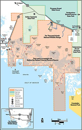
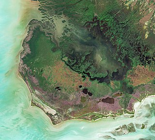
The Ten Thousand Islands are a chain of islands and mangrove islets off the coast of southwest Florida, between Cape Romano and the mouth of the Lostmans River. Some of the islands are high spots on a submergent coastline. Others were produced by mangroves growing on oyster bars. Despite the name, the islets in the chain only number in the hundreds.

<span class="mw-page-title-main">Shark Valley</span>

Shark Valley is a geological depression at the head of the Shark River Slough in far western Miami-Dade County, Florida, United States. It is currently part of Everglades National Park. Shark Valley empties into Shark River in the Ten Thousand Islands of Monroe County. Shark Valley characteristically includes sawgrass prairie that floods during the rainy season, hence the name "river of grass"—Pa-Hay-Okee, from the Mikasuki language—for such marshes in the Everglades. Shark Valley features a Visitor Center with educational displays, a park video, an underwater camera and informational brochures. The entrance to Shark Valley is located along Tamiami Trail near the Miami-Dade–Collier County line.

<span class="mw-page-title-main">Child of the Sun</span> United States historic place

Child of the Sun is a collection of buildings designed by Frank Lloyd Wright on the campus of the Florida Southern College in Lakeland, Florida. The twelve original buildings were constructed between 1941 and 1958. Another of Wright's designs, a Usonian house originally intended for faculty housing, was completed in 2013, and is now part of the Sharp Family Tourism and Education Center. On March 2, 2012, it was designated a National Historic Landmark. The buildings are listed on the National Register of Historic Places, and together form the largest collection of buildings by the architect Frank Lloyd Wright.

<span class="mw-page-title-main">Guy Bradley</span> American game warden and deputy sheriff (1870–1905)

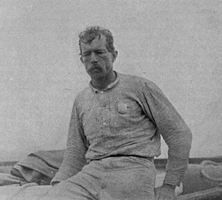
Guy Morrell Bradley was an American game warden and deputy sheriff for Monroe County, Florida. Born in Chicago, Illinois, he relocated to Florida with his family when he was young. As a boy, he often served as guide to visiting fishermen and plume hunters, although he later denounced poaching after legislation was passed to protect the dwindling number of birds. In 1902, Bradley was hired by the American Ornithologists' Union, at the request of the Florida Audubon Society, to become one of the country's first game wardens.

<span class="mw-page-title-main">Roosevelt Lodge Historic District</span> Historic district in Wyoming, United States

The Roosevelt Lodge Historic District comprises the area around the Roosevelt Lodge in the northern part of Yellowstone National Park, near Tower Junction. The district includes 143 buildings ranging in size from cabins to the Lodge, built beginning in 1919. The Lodge was first conceived as a field laboratory for students and educators conducting research in the park. It later became a camp for tourists, specifically designed to accommodate automobile-borne tourists. The Lodge is a simplified version of the National Park Service Rustic style.

<span class="mw-page-title-main">Meadow Lake Provincial Park</span> Provincial park in Saskatchewan, Canada

Meadow Lake Provincial Park is a northern boreal forest provincial recreational park along the Waterhen and Cold Rivers in the Canadian province of Saskatchewan. The park was founded on 10 March 1959, is the largest provincial park in Saskatchewan, and encompasses over 25 lakes in an area of 1,600 km2 (620 sq mi). The park was named "Meadow Lake" after the city of Meadow Lake and Meadow Lake. The city and the lake are not in the park and are located about 40 kilometres (25 mi) south-east of the nearest park entrance, which is about 5 kilometres (3.1 mi) north of Dorintosh. The length of the park stretches about 113 kilometres (70 mi) from Cold Lake on the Saskatchewan / Alberta border in the west to the eastern shore of Waterhen Lake in the east.

<span class="mw-page-title-main">Giant Forest Lodge Historic District</span> Historic district in California, United States

The Giant Forest Lodge Historic District in Sequoia National Park includes the remnants of what was once an extensive National Park Service Rustic style tourist development for park visitors. Also known as Camp Sierra, the district was listed on the National Register of Historic Places in May 1978. Originally situated in the Giant Forest grove of giant sequoias, the district is notable for its nearly total demolition by the National Park Service to eliminate the impact of development on the Big Trees.

<span class="mw-page-title-main">Watch Hill (New York)</span> Camground and marina on Fire Island, New York

Watch Hill is a campground and marina located on Fire Island, a barrier island off the south shore of New York's Long Island. The park is located across the Great South Bay from Patchogue and is contained within the Fire Island National Seashore.

<span class="mw-page-title-main">Colter Bay Village</span> Developed area of Grand Teton National Park, Wyoming, USA

Colter Bay Village is a developed area of Grand Teton National Park, Wyoming, USA. Located on the northeast side of Jackson Lake, it was built starting in the 1950s as part of the National Park Service's Mission 66 program to expand park visitor services and to adapt them to the requirements of automobile tourism. Hiking trails in the area include the Colter Bay Lakeshore Trail and the Heron Pond Swan Lake Trail.

<span class="mw-page-title-main">Everglades Wilderness Waterway</span> Recreational waterway in Florida

The Everglades Wilderness Waterway is a 99-mile navigable recreational waterway route within Everglades National Park, also known as Marjory Stoneman Douglas Wilderness. It includes many interconnecting creeks, rivers, lakes and inner bays that are navigable by shallow draft powerboat, kayak or canoe. The official Wilderness Waterway route is 99 miles long, but a traveler can use various additional route options to greatly extend or slightly shorten the trip.

<span class="mw-page-title-main">Poinciana, Monroe County, Florida</span> Planned community in Monroe County, Florida

Poinciana was a planned community that was to be located along the Lostmans River in Monroe County, Florida. Poinciana has been described as the Everglades's "most spectacular commercial enterprise" and "the prototype of all Florida scams".

References

  1. Google (March 24, 2013). "Map of Main Park Road, Everglades National Park" (Map). Google Maps . Google. Retrieved March 24, 2013.
  2. "Flamingo - Ghost Town". www.ghosttowns.com.
  3. Tebeau: p. 142
  4. Tebeau: p. 145
  5. "Everglades Biographies: Guy Bradley Archived May 9, 2021, at the Wayback Machine ". Everglades Digital Library. Retrieved on July 1, 2010.
  6. Tebeau: pp. 152-62
  7. "Christian Point Trail". National Park Service. Archived from the original on May 14, 2022. Retrieved October 20, 2022.
  8. "The True Story of the 1935 Labor Day Hurricane That Hit the Florida Keys". History. September 8, 2017. Archived from the original on April 19, 2021. Retrieved November 24, 2022.
  9. "NOWData - NOAA Online Weather Data". National Oceanic and Atmospheric Administration . Retrieved May 9, 2021.
  10. "Summary of Monthly Normals 1991-2020". National Oceanic and Atmospheric Administration . Retrieved May 9, 2021.
  11. "Lost to Hurricanes, the Flamingo Lodge at Everglades National Park Will be Hard to Replace | National Parks Traveler". www.nationalparkstraveler.org.
  12. "Everglades National Park will get new cabins and eco-tents at Flamingo by 2019 | Florida Rambler". www.floridarambler.com. September 3, 2021.
  13. "Camping | Everglades Flamingo". flamingoeverglades.com.
  14. "Winter Eco-Tent | Everglades Flamingo".
  15. "Flamingo Lodge & Restaurant | Everglades Flamingo".
  16. "Everglades announces grand opening of Flamingo Lodge & Restaurant and Guy Bradley Visitor Center on October 27".
  17. "Flamingo Visitor Center - Everglades National Park (U.S. National Park Service)". www.nps.gov.
  18. "Lost to Hurricanes, the Flamingo Lodge at Everglades National Park Will be Hard to Replace". www.nationalparkstraveler.com. National Parks Traveler.
  19. 1 2 "Canoe and Kayak Trails - Everglades National Park (U.S. National Park Service)". www.nps.gov.
  20. "Concession Tours in Everglades National Park - Everglades National Park (U.S. National Park Service)". www.nps.gov.
  21. "Boat Tours | Everglades Flamingo".
  22. "Houseboats | Everglades Flamingo".

Sources