Extreme points of Uruguay

Last updated
Map all coordinates using: OpenStreetMap  
Download coordinates as: KML  ·  GPX
Physical map of Uruguay. Uruguay fisico.png
Physical map of Uruguay.

This is a list of the extreme points of Uruguay , the points that are farther north, south, east or west than any other location, and the highest and lowest points. It is also notable that Uruguay's northernmost point is farther south than the northernmost point of any other nation.

Uruguay republic in South America

Uruguay, officially the Oriental Republic of Uruguay, is a country in the southeastern region of South America. It borders Argentina to its west and Brazil to its north and east, with the Río de la Plata to the south and the Atlantic Ocean to the southeast. Uruguay is home to an estimated 3.44 million people, of whom 1.8 million live in the metropolitan area of its capital and largest city, Montevideo. With an area of approximately 176,000 square kilometres (68,000 sq mi), Uruguay is geographically the second-smallest nation in South America, after Suriname.

North one of the four cardinal directions

North is one of the four cardinal directions or compass points. It is the opposite of south and is perpendicular to east and west. North is a noun, adjective, or adverb indicating direction or geography.
South one of the four cardinal directions

South is one of the four cardinal directions or compass points. South is the opposite of north and is perpendicular to the east and west.

Latitude and longitude

Artigas Department Place in Uruguay

Artigas Department is the northernmost department of Uruguay, located in its northwestern region. Its capital is the city of Artigas, which borders on the Brazilian city of Quaraí. Artigas Department has an area of 11,928 square kilometres (4,605 sq mi), making it the fifth largest in the country. The population is 73,378 inhabitants, according to the 2011 census.

Isla de Lobos island in Uruguay

The Isla de Lobos is a small island located about 8 kilometres (5.0 mi) southeast of Punta del Este (Uruguay). An islet lies east of the island.

Punta del Este City in Maldonado, Uruguay

Punta del Este is a city and resort on the Atlantic Coast in the Maldonado Department of southeastern Uruguay. Although the city has a year-round population of about 9,280, the summer tourist boom adds to this a very large number of non-residents. Punta del Este is also the name of the municipality to which the city belongs. It includes Punta del Este proper and Península areas.

Altitude

Cerro Catedral (Uruguay) mountain in Uruguay

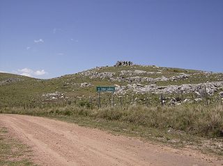
Cerro Catedral, also known as Cerro Cordillera, is a peak and the highest point of Uruguay, with an altitude of 513.66 m (1,685.2 ft). It is located north of Maldonado Department, in the municipality of Aiguá, in a hill range named Sierra Carapé, which constitutes part of a larger range named Cuchilla Grande. Its name derived from the curious forms of the rocky elevations of its summit, which are very common in the southern part of this country.

Sierra Carapé mountain range

Sierra Carapé or Sierra de Carapé is a hill range located in Maldonado Department, in southern Uruguay. The range crosses the Maldonado Department from west to east and enters the Rocha Department.

Maldonado Department Place in Uruguay

The Maldonado Department, with an area of 4,793 km2 (1,851 sq mi) and 190,500 inhabitants, is located to the southeast of Uruguay. Its capital is Maldonado.


Related Research Articles

This is a list of the extreme points of Ireland – the points that are farthest north, south, east or west in Ireland. It includes the Republic of Ireland and Northern Ireland.

This is a list of the extreme points of South America, the points that are farther north, south, east or west than any other location on the continent. The continent's southernmost point is incorrectly often said to be Cape Horn, but Águila Islet of the Diego Ramirez Islands is actually the southernmost point.

This is a list of the extreme points of Central America, the points that are farther north, south, east, or west than any other location on the region. The list also included highest and lowest points and identifies the most extensive lake.

Extreme points of the Philippines

This is a list of the extreme points of the Philippines, the points that are farther north, south, east or west than any other location in the country.

This is an article about the extreme points of Indonesia.

This is a list of the extreme points and extreme elevations in Scotland.

The Chuí, or Chuy, Stream, is a short stream on the Brazilian–Uruguayan border that is celebrated as Brazil's southernmost point.

This is a list of the extreme points of Colombia, the points that are farther north, south, east or west than any other location.